[Mount Chokai-Tobishima Geopark: Nikaho Edition (1)] Kujukushima, which is considered to be on par with Matsushima but became land due to a major earthquake
table of contents
- 1 The Nikaho area is full of fascinating natural beauty created by Mt. Chokai
- 2 The landscape of Kujukushima (Kizagata), completely changed by a major earthquake during the Edo period
- 3 "Buried trees" buried by a rock avalanche caused by the collapse of Mt. Chokai
- 4 Karato Stone: A precious rock that reveals the uplift caused by the Kisakata earthquake
- 5 The Nikaho City Kisakata Local History Museum displays materials related to the origins of Kisakata and "The Narrow Road to the Deep North"
- 6 Misaki Coast, formed by lava from Mt. Chokai, and the old Misakiyama Highway, a difficult road for travel
- 7 Articles related to Mt. Chokai and Tobishima Geopark
Nikaho City Mount Chokai-Tobishima Geopark along with the Yurihonjo area in Akita Prefecture and the Sakata, Yuza, and Tobishima areas in Yamagata Prefecture.
A geopark is a park rich in nature that contains various natural heritage sites related to the geological formations (GEO = Earth), such as strata, rocks, topography, volcanoes, and faults
This is a place where you can look closely at mountains and rivers, begin by noticing their origins, and think about their relationship to ecosystems and people's lives. From the rocks under your feet to the universe above, from the past billions of years to the future, you can think about the natural world of the seas and mountains as one with the creatures and people who live there
In other words, a geopark is a place where we can think about the Earth as a whole" (from the Chokai-Tobishima Geopark website)
The Nikaho area is full of fascinating natural beauty created by Mt. Chokai
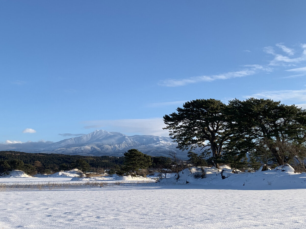
the Nikaho Area of Mount Chokai-Tobishima Geopark is, first and foremost, the diverse landscapes created by the active volcano Mount Chokai, just like the other areas.
The area is dotted with dynamic coastlines, large valleys, waterfalls, and marshes. Among them, the Kujuku Islands, known as Kisakata, are a unique landscape created by the collapse of Mount Chokai about 2,500 years ago, and are designated as a national natural monument
In addition to the Kujukushima Islands, the landscape created by the eruption of Mt. Chokai is dotted with many other sights, including Misaki Coast, formed from lava that is approximately 3,000 years old; Naso Valley, where lava flowing from multiple eruptions is piled up in layers like a mille-feuille; and Shishigahana Marsh, a marshland formed by spring water gushing out from the tip of a lava flow
The Earth's troublesome activities, such as mountain collapses and lava flows caused by eruptions, are beyond human control, but the ingenuity of the people who try to cope with them is one of the charms of the Nikaho area. In addition, the gifts of the Earth, such as oil and wind, have enriched human life
We will introduce the fascinating Nikaho Area Geopark in two parts
Mt. Chokai-Tobishima Geopark <Information>
- Mount Chokai and Tobishima Geopark Nikaho Area
- URL: Mt. Chokai and Tobishima Geopark Nikaho Area
The landscape of Kujukushima (Kizagata), completely changed by a major earthquake during the Edo period
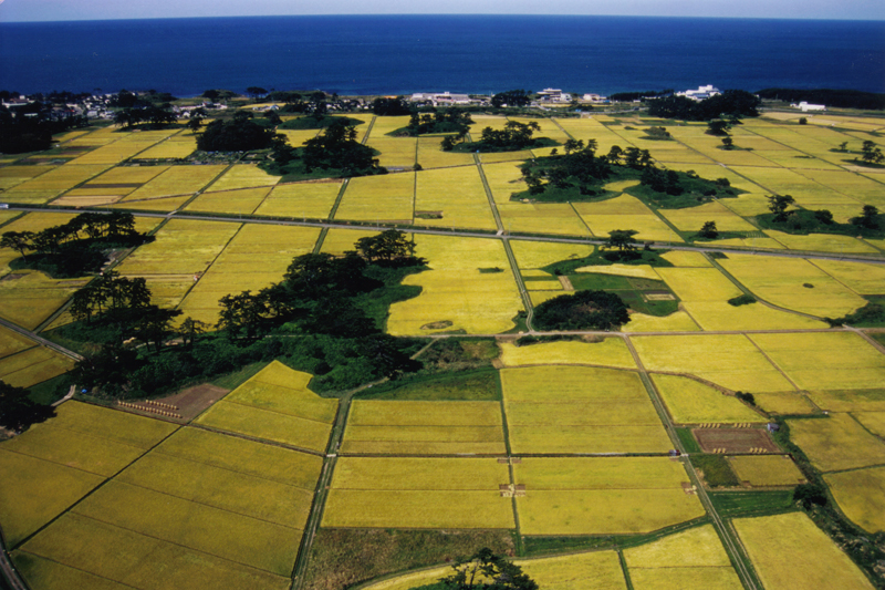
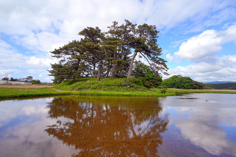
Kujukushima where large and small islands emerge from the rice paddies , is a landscape created by the activity of the Earth. Approximately 2,500 years ago, a large mountain collapsed near the summit of Mount Chokai, causing a huge amount of sediment to flow down towards the Sea of Japan. The sediment filled the sea, forming a shallow lagoon, and the large rocks that fell formed several masses (nagareyama) that emerged from the sea like islands. Over the years, trees grew on the large protruding rocks, and they became like islands.
The scenery is so similar to Matsushima (one of Japan's Three Scenic Views, Miyagi Prefecture) that the Heian period monks and poets Noin and Saigyo were so moved by it that they wrote about it in their waka poems. The Edo period haiku poet Matsuo Basho visited Kisakata, desperate to see the scenery that Noin and Saigyo had written about in their waka poems, and wrote in his book "Oku no Hosomichi" (1702) that he was so impressed
However, the Earth's mischief did not end there. On July 10, 1804 (solar calendar), an earthquake with an estimated magnitude of 7.0 struck Kisakata. This earthquake caused the area to rise by more than 2 meters, and the Kujukushima Islands, which consisted of many floating islands, dried up and became land

Today, Kujukushima is a rare sight, with rice fields now covering what was once a lagoon, with over 100 islands floating in the rice paddies
Kujukushima <Information>
- Facility name: Kujukushima (Kizakata)
- Location: Shioyakijima, Kisakata-cho, Nikaho City, Akita Prefecture
- Phone number: 0184-43-6608 (Nikaho City Tourism Association)
- URL: Kujukushima (Kizakata)
- access:
- Public transportation: Approximately 15 minutes on foot from Kisakata Station on the JR Uetsu Main Line
- By car: Approximately 8 minutes from Kisakata IC on the Nihonkai Tohoku Expressway
GOOGLE MAP
"Buried trees" buried by a rock avalanche caused by the collapse of Mt. Chokai
The collapse of Mt. Chokai, which created the landscape of the Kujukushima Islands, is said to have released approximately 6 billion tons of soil and debris (it is difficult to imagine how much this amount is, but if the dry soil and debris were equivalent to the volume of one Tokyo Dome, it would weigh about 150,000 tons, which is equivalent to about 40,000 Tokyo Domes)
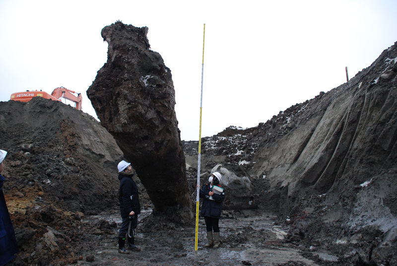
The forest was instantly covered in soil and sand, remaining trapped underground for tens of millions of years without exposure to air. These buried trees (buried trees) were prized as completely dry natural timber that was hard to come by and had been dug up all over the country, but in Nikaho City, they had been actively excavated in the Toushi and Kamagatai districts since the 1970s. In 2015, around 150 trees were discovered during construction of the Kisakata Interchange on the Japan Sea Coast Tohoku Expressway
At Kisakata IC, the buried trees were not found standing, but mostly felled. It is believed that this location was on the edge of the soil and sand that flowed out from the landslide, and that the trees were washed down the mountainside and deposited there. Among the trees was a zelkova tree measuring 10m in length and 1.6m in diameter. Furthermore, by examining the tree rings of the buried trees (tree-ring dating), it was possible to determine when the landslide of Mt. Chokai occurred
The buried wood is on display at Nikaho City Kisakata Local History Museum
Karato Stone: A precious rock that reveals the uplift caused by the Kisakata earthquake
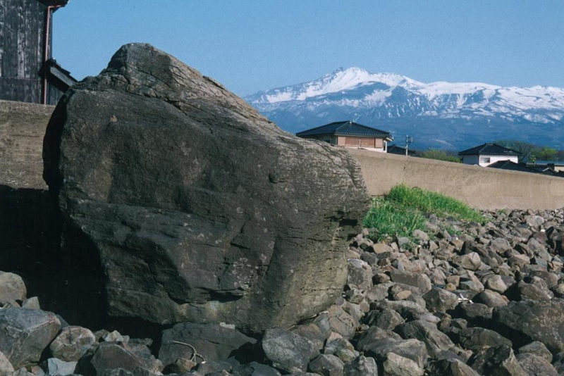
The Karato Stone is one of the rocks that fell when Mt. Chokai collapsed. Although it looks like an ordinary rock, it has been carefully preserved as a witness to the Kisakata uplift caused by the 1804 Kisakata earthquake.
Before the earthquake, the rock was slightly above sea level, but after the earthquake it was completely above ground. It is 4.3m high, but there are traces of wave erosion about 2.4m from the bottom, and the rock was submerged up to 2.4m in the sea. In other words, it was discovered that the seabed of Kisakata had risen by about 2.4m and become land. The Karato Stone has been designated as a historic site by Nikaho City
Karato Stone <Information>
- Facility name: Karatoishi
- Location: Nakahashicho, Kisakata-machi, Nikaho City, Akita Prefecture
- Phone number: 0184-43-6608 (Nikaho City Tourism Association)
- URL: Karato Stone
- access:
- Public transportation: Approximately 5 minutes by taxi from Kisakata Station on the JR Uetsu Main Line
- By car: Approximately 10 minutes from Kisakata IC on the Nihonkai Tohoku Expressway
GOOGLE MAP
The Nikaho City Kisakata Local History Museum displays materials related to the origins of Kisakata and "The Narrow Road to the Deep North"
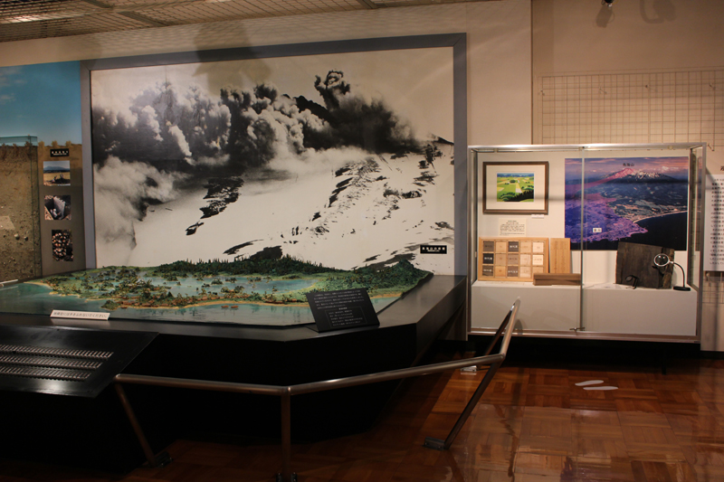
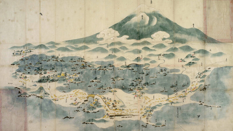
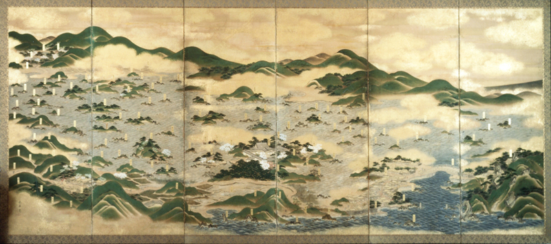
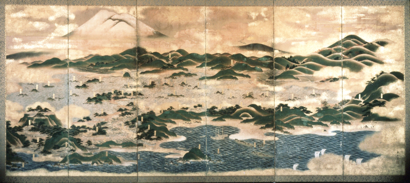
The Nikaho City Kisakata Local History Museum displays the completely different landscape of the Kujukushima Islands that was created by the Kisakata earthquake, the "Kisakata Colored ," a folding screen depicting the islands before uplift, and a 1/825 scale model. The museum also displays materials related to Matsuo Basho's "Oku no Hosomichi," as well as materials related to Shiokoshi Port, which flourished as a port of call for Kitamaebune (merchant ships that conducted large business between Tohoku, Hokkaido, and Kansai, traveling through ports on the Sea of Japan) from the Edo to Meiji periods.
Nikaho City Kisakata Local History Museum <Information>
- Facility name: Nikaho City Kisakata Local History Museum
- Address: 31-1 Kitsunemori, Kisakata-cho, Nikaho City, Akita Prefecture
- Phone number: 0184-43-2005
- Opening hours: 9:00-17:00
- Closed: Mondays, the day after national holidays and substitute holidays, and the New Year holidays (December 29th to January 3rd)
- Admission fee: Adults 150 yen, High school students and other students 100 yen, Elementary and junior high school students 50 yen
- URL: Nikaho City Kisakata Local History Museum
- access:
- Public transportation: Approximately 3 minutes by car from Kisakata Station on the JR Uetsu Main Line
- By car: Approximately 3 minutes from Kisakata IC on the Nihonkai Tohoku Expressway
GOOGLE MAP
Misaki Coast, formed by lava from Mt. Chokai, and the old Misakiyama Highway, a difficult road for travel
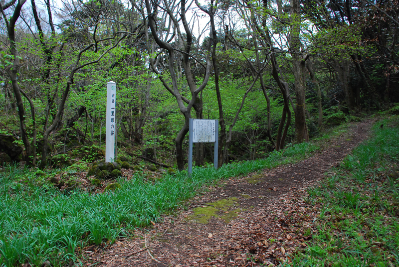
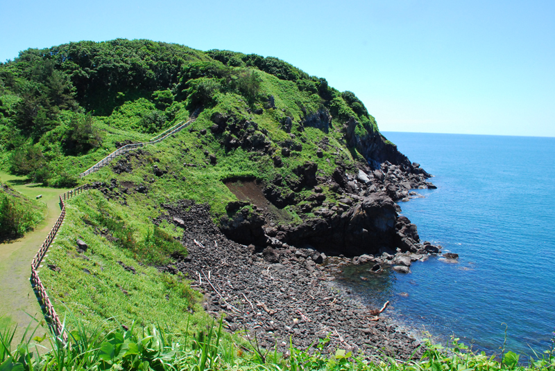
Misaki Coast was formed when lava (andesite) flowed out from the eruption of Mount Chokai about 3,000 years ago and flowed all the way to the sea. The lava flow is about 60 meters thick, and the sheer volume is overwhelming.
Located on the border between Akita and Yamagata prefectures, the sheer cliffs and rugged lava rock formations along the coastline are a sight to behold
The old Misakiyama Highway, which remains on Misaki Coast, has long been a difficult stretch of road connecting Yamagata and Akita. Lava flows from Mt. Chokai fall directly into the Sea of Japan, and the coastline is full of cliffs. There are almost no flat areas. What's more, Misaki has three capes - Kannonzaki, Daishizaki, and Fudozaki - and you can't reach the other side without crossing three mountain passes. There are many places on the road where you wonder why it ended up in such a place, and it is said that many travelers lost their lives
During the Edo period, Matsuo Basho passed through here on his way to Kisakata, and the mapmaker Ino Tadataka and travel writer Sugae Masumi also passed through here on their pilgrimages. It is also the site of the outbreak of the Akita War (1868), which broke out during the Meiji Restoration, when forces from Akita, including the Kubota clan, clashed with the Shonai clan of Yamagata
The Misaki Peninsula was named after the three capes within the peninsula: Kannonzaki, Daishizaki, and Fudozaki. Misaki (Daishizaki) is a nationally designated scenic spot, part of the "Narrow Road to the Deep North."
Misaki Coast <Information>
- Facility name: Misaki Coast (Misaki Park)
- Location: Kosagawa Misaki, Kisakata-cho, Nikaho City, Akita Prefecture
- Phone number: 0184-43-6608 (Nikaho City Tourism Association)
- access:
- Public transportation: Approximately 15 minutes by car from Kisakata Station on the JR Uetsu Main Line
- By car: Approximately 15 minutes from Kisakata IC on the Nihonkai Tohoku Expressway




![[Mount Chokai-Tobishima Geopark: Yuza and Sakata] The Shonai Plain is blessed with the bounty of Mount Chokai b5339749745ac9c7a01a8bb8dc81755e](https://jp.neft.asia/wp-content/uploads/2023/05/b5339749745ac9c7a01a8bb8dc81755e-150x150.jpg)
![[Mt. Chokai-Tobishima Geopark: Nikaho (2)] Coexistence with nature brought about by the wisdom of our ancestors 1 Nikaho Plateau, 2000, Nikaho City Cultural Properties Protection Division](https://jp.neft.asia/wp-content/uploads/2024/10/28389310d744abdc1b4ca5d863e123e7-150x150.jpg)
![[Mount Chokai-Tobishima Geopark: Yurihonjo Edition] See the geological layers from when Japan was part of the Eurasian continent b5c46a18bc0cc79de0e9ad08084eaa5b](https://jp.neft.asia/wp-content/uploads/2024/04/b5c46a18bc0cc79de0e9ad08084eaa5b-150x150.jpg)
![[Mt. Chokai-Tobishima Geopark: Tobishima] Tobishima, which prospered during the Edo period due to the Kitamaebune shipping b78c09f26796b9608d6c3fb7a83ecc50](https://jp.neft.asia/wp-content/uploads/2023/05/b78c09f26796b9608d6c3fb7a83ecc50-150x150.jpg)
![Learn about the history of Nikaho City, which was formed by the merger of three towns connected to the Nikaho clan [Akita Prefecture] 10 Kujukushima Akita Prefecture 800](https://jp.neft.asia/wp-content/uploads/2024/10/5ce06ecf5220abbacd746be7687e94f4-150x150.jpg)
![The Wooden Toy Museum is housed in an abandoned school! Access it by toy train [Yurihonjo, Akita Prefecture] 02 Mt. Chokai Wooden Toy Museum](https://jp.neft.asia/wp-content/uploads/2018/11/cce286efc423e9c7e7b7514902aaaac3-150x150.jpg)
