[Mt. Chokai-Tobishima Geopark: Nikaho (2)] Coexistence with nature brought about by the wisdom of our ancestors
table of contents
- 1 Nakajimadai Shishigahana Marsh is a marshland where giant beech and oak trees and rare mosses grow
- 2 Naso Valley: A 500m vertical wall where lava flowing from multiple eruptions is piled up like a mille-feuille
- 3 Naso no Shirataki and Kinpu Shrine, famous waterfalls where mountain ascetics practiced
- 4 A comfortable mountain highway: the Chokai Blue Line
- 5 Nikaho Plateau, 500m above sea level, is where the soil and sand that flowed down from the collapse of Mt. Chokai piled up at the foot of the mountain
- 6 Shin-Nigahokogen Wind Power Plant, one of Japan's largest wind power plants
- 7 Kamigo's Heated Water Channels raise the temperature of cold meltwater to a level suitable for rice cultivation
- 8 Yuri Coast Wave-breaking Stone Wall Protected Houses and Farmland from Large Waves and Winds
- 9 The Innai Oil Field, once one of Japan's leading oil producers
- 10 Articles related to Mt. Chokai and Tobishima Geopark
In the first part of the Mt. Chokai-Tobishima Geopark , the Kujukushima Islands (Kizakata) and Misaki Coast . In the second part, we will introduce inland geosites and the wisdom of our ancestors on coexisting with the global environment.
Nakajimadai Shishigahana Marsh is a marshland where giant beech and oak trees and rare mosses grow
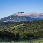
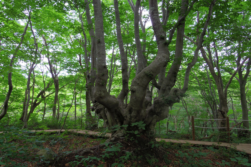
Nakajimadai is a forest and marshland area located at the foot of Mount Chokai at an altitude of about 450m to 830m, and has been designated as Chokai Natural Recreation Forest
It covers an area of approximately 942 hectares (about 200 Tokyo Domes) and is home to the rich natural beauty of Mount Chokai, including giant beech and oak trees and the Shishigahana Marsh flow.
A 5km long boardwalk walking course has been established around Nakajimadai and Shishigahana Marsh. Along the walking course, oddly shaped beech and oak trees known as Agariko creating a mystical landscape along with Agariko Daio, which has been selected as one of Giants of the Forest
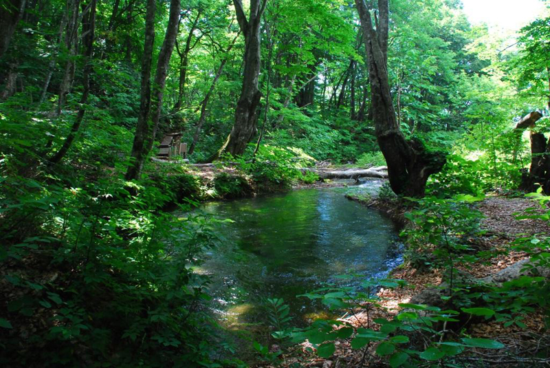
Shishigahana Marsh is located at an altitude of 550m and is nourished by abundant spring water, allowing a wide variety of aquatic wetland plants to grow
Among these, Handel's moss and Platycodon platypus are rare even worldwide, and when these mosses grow together in a ball shape, they are commonly known as "Chokai Marimo."
The marshland also features a spring known as " Detsubo " and cliffs at the end of Mt. Chokai's lava flow, and has been designated a national natural monument.
Nakajimadai and Shishigahana Marsh <Information>
- Facility name: Nakajimadai/Shishigahana Marsh
- Location: Nakajimadai National Forest, Yokooka, Kisakata-cho, Nikaho City, Akita Prefecture
- Phone number: 0184-43-6608 (Nikaho City Tourism Association)
- access:
- Public transportation: Approximately 20 minutes by car from Kisakata Station on the JR Uetsu Main Line, then walk
- By car: Approximately 15 minutes from Kisakata IC on the Nihonkai Tohoku Expressway
Google Map
Naso Valley: A 500m vertical wall where lava flowing from multiple eruptions is piled up like a mille-feuille
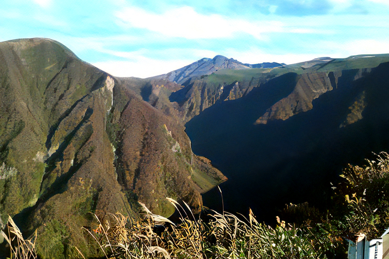
Naso Valley is a valley located near the 6th station of Mt. Chokai, and is about 300m to 500m deep. The river has carved the lava layer over many years, creating a V-shaped valley.
The sheer cliffs are made up of lava from Mt. Chokai, which has erupted repeatedly since about 600,000 years ago, piled up and resemble a mille-feuille. The lava at the bottom of the valley is said to be 400,000 to 450,000 years old, and the lava at the top is about 100,000 years old
Naso Valley is impressive just looking up at it from below, but you can also get a bird's-eye view of the valley from the Hokotate Observatory at the 5th station of Mt. Chokai
The valley that can be seen below Hokotate Observatory is 337m deep, and Tokyo Tower (333m) could fit inside it. You can reach Hokotate Observatory via the Chokai Blue Line (closed for winter from early November to late April), which runs along the middle of Mount Chokai. From Hokotate Observatory, you can see all the way to Tobishima Island and the Oga Peninsula below, making it one of the best views in the Nikaho area
Naso Valley <Information>
- Facility name: Naso Valley (Hokotate Observatory)
- Location: Kotaki (Hokotate), Kisakata-cho, Nikaho City, Akita Prefecture
- Phone number: 090-2021-0270 (Hokotate Visitor Center)
- access:
- Public transportation: Approximately 35 minutes by reservation-only shared mountain climbing bus, Chokai Blue Liner, or approximately 30 minutes by car from Kisakata Station on the JR Uetsu Main Line
- *Chokai Blue Liner operates on weekends and holidays from June to early October
- *The mountain highway "Chokai Blue Line" is closed during the winter from early November to late April
- *Chokai Blue Liner operates on weekends and holidays from June to early October
- Public transportation: Approximately 35 minutes by reservation-only shared mountain climbing bus, Chokai Blue Liner, or approximately 30 minutes by car from Kisakata Station on the JR Uetsu Main Line
- By car: Approximately 15 minutes from Kisakata IC on the Nihonkai Tohoku Expressway
Google Map
Naso no Shirataki and Kinpu Shrine, famous waterfalls where mountain ascetics practiced
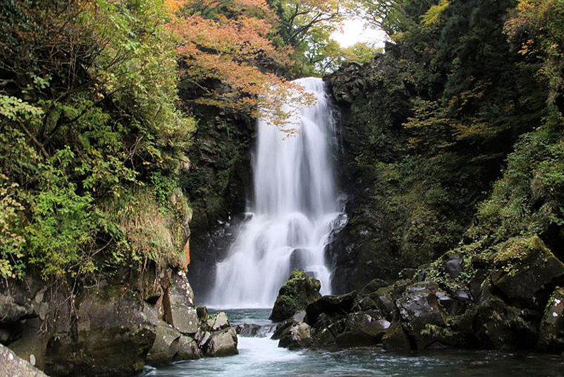
Naso no Shirataki is a famous waterfall located near the starting point of the Chokai Blue Line on the Akita Prefecture side
Kinpo Shrine , which was once the base for Shugenja (mountain ascetics) who used Mt. Chokai as a training ground , and climbing up and down a long flight of stairs, you will reach the waterfall. It is 26m high and 11m wide and has been designated a national scenic spot. You can go down to the basin of the falls and enjoy the waterfall from various angles, including from the observation deck, the grounds, and the suspension bridge.
Naso Shirataki Falls/Kinpu Shrine <Information>
- Facility name: Naso Shirataki/Kinbo Shrine
- Location: Otaki, Nasozawa-Ohido, Kisakata-machi, Nikaho City, Akita Prefecture
- Phone number: 0184-43-6608 (Nikaho City Tourism Association)
- access:
- Public transportation: Approximately 15 minutes by car from Kisakata Station on the JR Uetsu Main Line, then walk
- By car: Approximately 6 minutes from Kisakata IC on the Nihonkai Tohoku Expressway
Google Map
A comfortable mountain highway: the Chokai Blue Line
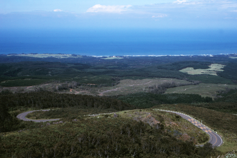
is a mountain tourist road stretching approximately 34.9 km from Naso no Shirataki in Kisakata Town, Nikaho City Fukiura Juroku in Yuza Town, Yamagata Prefecture
Fukiura in Yuza Town, where the tourist attraction Juroku Rakan Rocks Hokotate (Naso Valley Hokotate Observation Deck) at 1,150m. The difference in altitude is over 1,000m, and the route runs through grasslands on the Akita side and beech forests on the Yamagata side.
From the Akita Prefecture side, the Sea of Japan stretches out to sea, and on the opposite mountain side, the majestic landscape of the Naso Valley looms
The Chokai Blue Line passes through a heavy snow area and is therefore closed from early November to late April. There is no toll, but please be careful when driving as it is a popular spot for bicycle touring
Chokai Blue Line <Information>
- Facility name: Chokai Blue Line
- section:
- Akita Prefecture side / Prefectural Route 131, Chokai Park Kotaki Line: 18.1km from Kotaki (prefectural border) to Kotaki (Naso Shirataki)
- Yamagata Prefecture side / Prefectural Route 210, Chokai Park Fukiura Line, from Fukiura (prefectural border) to Fukiura (Juroku Rakan Rocks), 16.8km
- Toll: Free
- Passable period: Late April to early November (closed in winter)
- *The passable period varies depending on the weather conditions each year
- Closure and restriction information:
- Akita Prefecture/ Akita Road Information
- Yamagata Prefecture / Traffic regulations in Yamagata Prefecture
- Japan Road Traffic Information Center/ Japan Road Traffic Information Center
Google Map
Nikaho Plateau, 500m above sea level, is where the soil and sand that flowed down from the collapse of Mt. Chokai piled up at the foot of the mountain
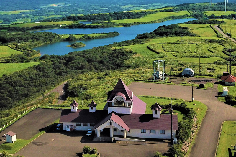
The Nikaho Plateau is a hilly area about 500m above sea level, formed by rocks that fell like an avalanche when Mt. Chokai collapsed.
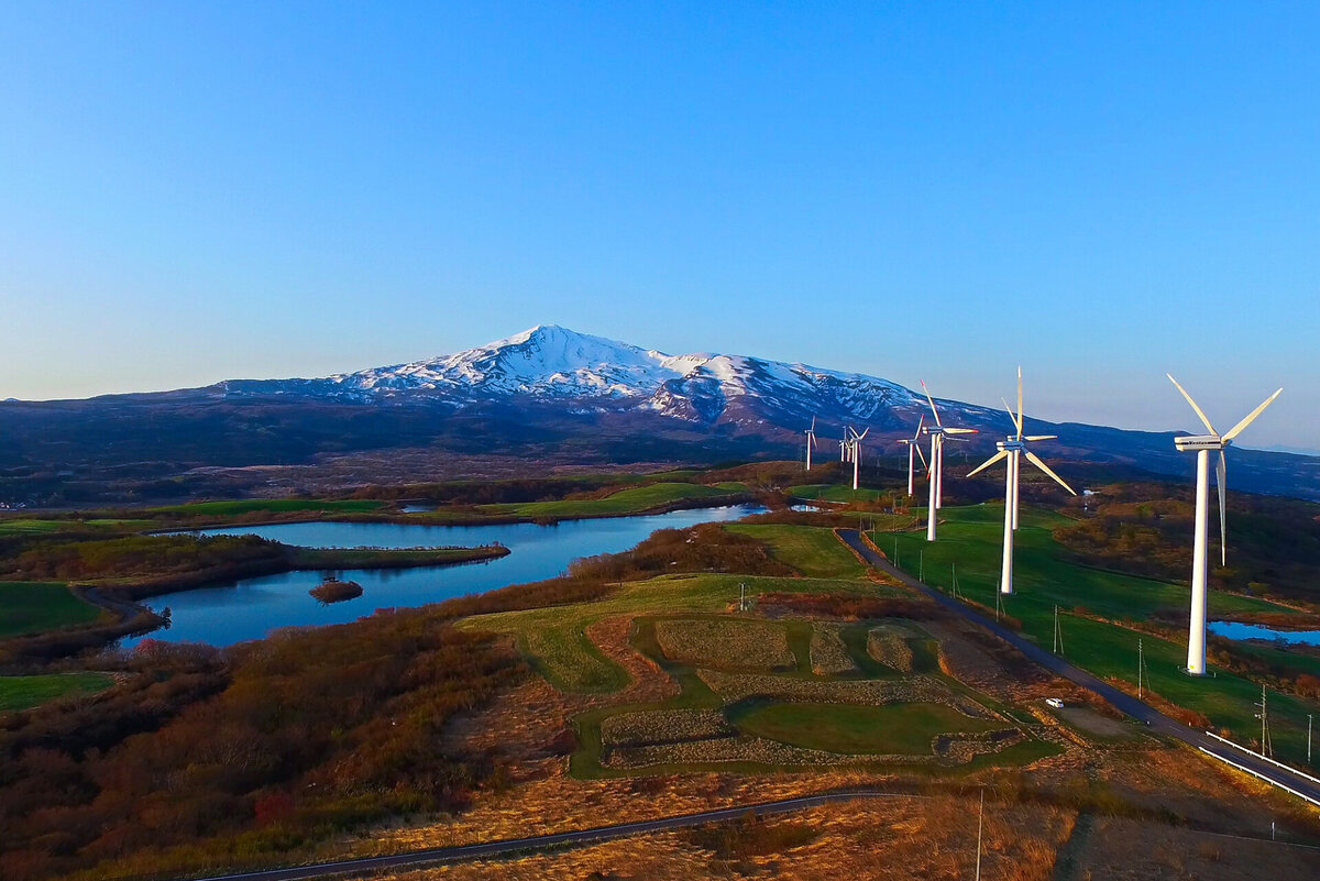
Within the grasslands, there are large and small lakes, marshes, marshes, and large-scale wind power generation facilities. From the observation deck of Hibari-so, the base facility of the Nikaho Plateau , you can see not only the majestic Mt. Chokai but also the Sea of Japan, and the 360-degree panoramic view is a must-see.
There are also ranches and campgrounds scattered around the area, and cycling paths have been developed. Tsuchida Farm , milk, yogurt, cheese, and other products made with raw milk from the Jersey cows they raise are extremely popular. Their sausages are also highly rated.
Nikabo Highland <Information>
- Facility name: Nikaho Plateau
- Location: Baba Magashigoya, Nikaho City, Akita Prefecture, and other locations
- access:
- Public transportation: Approximately 20 minutes by car from Nikaho Station on the JR Uetsu Main Line, or take a shared taxi (reservation required, for 2 or more people)
- By car: Approximately 20 minutes from Nikaho IC on the Nihonkai Tohoku Expressway
- *Shared taxi
- Phone number: 0184-43-2030 (Kisagata Joint Transportation)
- Opening period: July 1st to November 30th
- Reservations: Reservations required, minimum 2 people
- URL: Nikaho City Shared Taxi
- Facility name: Hibari-so/Nigahokogen Observatory
- Address: 4-5 Baba Magushigoya, Nikaho City, Akita Prefecture
- Phone number: 0184-43-3230 (Nikaho City Tourism Division)
- Opening hours: 9:00-17:00 (campsite reception hours)
- Opening period: May to end of November
- Facility name: Tsuchida Farm
- Address: 4-6 Toshiyama, Baba, Nikaho City, Akita Prefecture
- Phone number: 0184-36-2348
- Opening hours:
- March to December: 9:00 to 17:00
- January and February: 9:30-17:00
- Closed: Irregular holidays (please inquire in advance)
- URL: Tsuchida Farm
Google Map
Shin-Nigahokogen Wind Power Plant, one of Japan's largest wind power plants
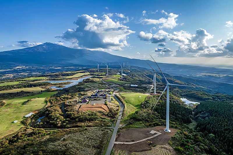
the Nikaho Plateau Wind Power Plant , which has been in operation since 2001, Nikaho No. 2 Wind Power Plant which began commercial operation in 2020. However, the Nikaho Plateau Wind Power Plant has been undergoing replacement work since 2021.
Construction was completed in March 2024, and the completely new "Shin-Nigahokogen Wind Power Plant" began commercial operation
The Shin-Nigahokogen Wind Farm originally had five wind turbines (each with an output of 1,650kW), but this has been upgraded to six 4,300kW wind turbines, the largest in Japan. The output remains unchanged from before the replacement (operation is restricted to the previous output of 24,750kW), bringing the total power generation at Nikahokogen to 66,150kW
Shin-Nigahokogen Wind Power Plant <Information>
- Facility name: Shin-Nigahokogen Wind Power Plant
- Location: Nikaho City, Akita Prefecture
- Operating company: J-Wind Co., Ltd. (J-Power Group)
- *J-POWER is the communication name of Electric Power Development Co., Ltd
Google Map
Kamigo's Heated Water Channels raise the temperature of cold meltwater to a level suitable for rice cultivation
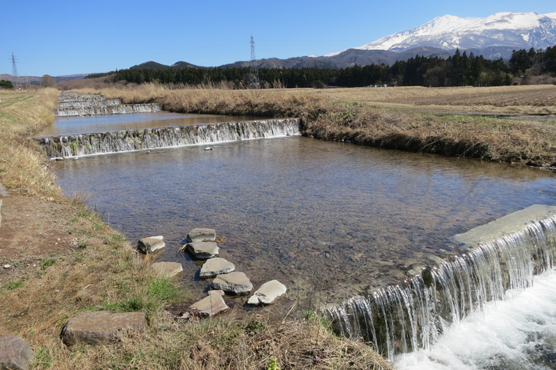
The Kamigo warm water canals were invented by farmers who used the cold meltwater from Mt. Chokai for rice cultivation, in order to warm the water, which was too cold, to a temperature suitable for rice cultivation
The meltwater from Mt. Chokai is only around 10°C even in summer, which is too cold for rice cultivation and does not promote good growth. Therefore, methods were devised to make the waterways wider, shallower, and with steps to expose the meltwater to sunlight and heat it up. This resulted in a rise in water temperature of 2 to 8°C, which dramatically increased rice yields
The first hot water channel in Japan was the 648m long Nagaoka Hot Water Channel, built in 1927 (Showa 2). Many other hot water channels have been built since then, including the Omori Hot Water Channel and the Mizuoka Hot Water Channel, with a total length of 6.28km
The Kamigo Hot Water Canals are one of the Ministry of Agriculture, Forestry and Fisheries' " 100 Canals " and designated as tangible cultural properties (structures) by Akita Prefecture .
Kamigo Warm Water Canals <Information>
- Facility name: Kamigo hot water channels
- Location: Yokooka, Kisakata-cho, Nikaho City, Akita Prefecture, and other locations
- Phone number: 0184-43-3230 (Nikaho City Tourism Division)
- access:
- Public transportation: Approximately 5 minutes by taxi from Kisakata Station on the JR Uetsu Main Line
- By car: Approximately 5 minutes from Kisakata IC on the Nihonkai Tohoku Expressway
Google Map
Yuri Coast Wave-breaking Stone Wall Protected Houses and Farmland from Large Waves and Winds
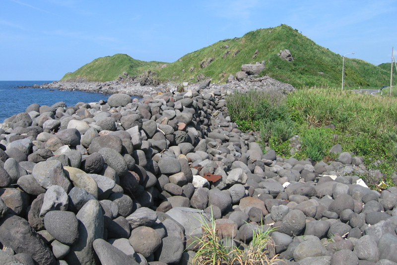
Yuri coast wave prevention stone wall<Information>
- Facility name: Yuri Coast Wave Breaking Stone Wall
- Location: Tobi, Nikaho City, Akita Prefecture, Serida, Nikaho City
- Phone number: 0184-43-3230 (Nikaho City Tourism Division)
- access:
- Public transportation: (Flight) 4 minutes by taxi from Kanaura Station on the JR Uetsu Main Line, (Serita) Approximately 6 minutes by taxi from Nikaho Station on the JR Uetsu Main Line
- By car: (Flight) Approximately 5 minutes from Konoura IC on the Nihonkai Tohoku Expressway (Serita) Approximately 7 minutes from Nikaho IC on the Nihonkai Tohoku Expressway
Google Map
The Innai Oil Field, once one of Japan's leading oil producers
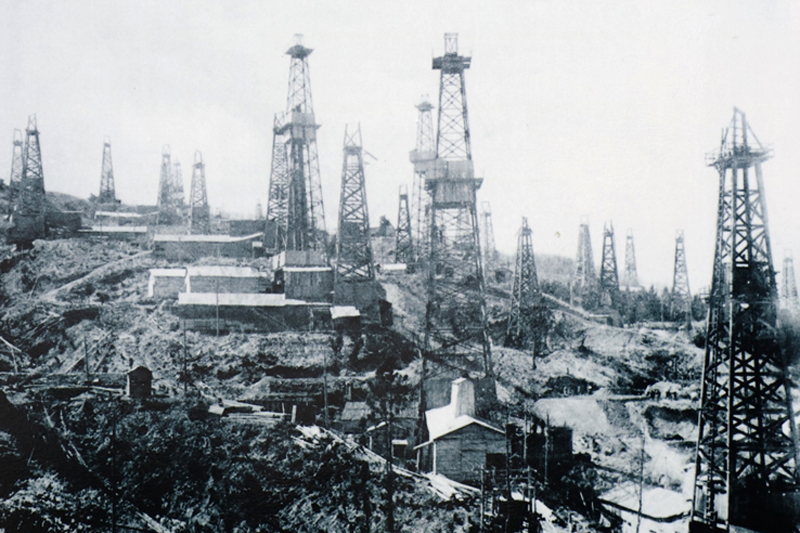
The Innai Oil Field (Innai, Nikaho City) was once one of the largest oil fields in Japan, and its former site has been preserved as part of the Ministry of Economy, Trade and Industry Awards as part of the "Modern Industrial Heritage Group 33: Modern Industrial Heritage Group that tells the story of Japan's modern oil industry, which began in the Kanto-Koshinetsu region, including Niigata."
Japan's oil industry began with mining in Echigo (Niigata Prefecture) in the late 16th century. It got fully underway in the early Meiji period, when engineers were invited from the United States to conduct oil reserve surveys mainly in the Koshinetsu and northern Japan regions
The first oil to be produced since the Meiji era was in Sagara Town, Shizuoka Prefecture (Sagara, Makinohara City) in 1873. After that, large oil fields were discovered on the Sea of Japan side of Niigata Prefecture, and Japan's oil industry boomed
At the end of the Meiji period, the wave of oil development reached not only Niigata Prefecture, but also Akita Prefecture. In 1914 (Taisho 3), a large amount of crude oil gushed out from an oil field discovered in Akita City. This attracted the attention of many oil companies, and an oil development boom arrived in Akita Prefecture
The existence of an oil field in Innai, Nikaho City was apparently discovered in the late Meiji period, but full-scale exploration began in 1922 (Taisho 11), with successful oil production the following year in 1923. In 1932 (Showa 7), Asahi Oil (the predecessor to Showa Oil [now Idemitsu Kosan]) succeeded in producing 8 kiloliters of oil per day
The Innai Oil Field reached its peak in 1935 (Showa 10), with a total annual production of 110,000 kiloliters, making it one of Japan's leading oil fields. However, production gradually declined due to the depletion of resources and a decline in international competitiveness, and the mine was closed in 1995 (Heisei 7)
The 33rd Modern Industrial Heritage Site Group, "Modern Industrial Heritage Sites that tell the story of Japan's modern oil industry, which began in the Kanto-Koshinetsu region, including Niigata," includes the Innai Oil Field-Related Heritage Sites, as well as Toyokawa Oil- Related Heritage Sites (Katagami City, Akita Prefecture), -Related Heritage Sites (Oil Village Park) (Akiha Ward, Niigata City, Niigata Prefecture), (Izumozaki Town, Niigata Prefecture), and Sagara Oil Field-Related Heritage Sites (Makinohara City, Shizuoka Prefecture).
Former Hospital Oil Field Site <Information>
- Facility name: Former Innai Oil Field
- Location: Innai, Nikaho City, Akita Prefecture
- Phone number: 0184-62-9777 (Mount Chokai-Tobishima Geopark)
- Tours: Available
- access:
- Public transportation: Approximately 16 minutes by taxi from Nikaho Station on the JR Uetsu Main Line
- By car: Approximately 15 minutes from Nikaho IC on the Nihonkai Tohoku Expressway
Google Map
Mt. Chokai-Tobishima Geopark <Information>
- Mount Chokai and Tobishima Geopark Nikaho Area
- URL: Mt. Chokai-Tobishima Geopark Nikaho Area




![[Mount Chokai-Tobishima Geopark: Nikaho Edition (1)] Kujukushima, which is considered to be on par with Matsushima but became land due to a major earthquake 1Kujukushima Winter 1_Nikaho City Tourism Division](https://jp.neft.asia/wp-content/uploads/2024/10/9832b69b3165ff52241c17ad3f8bf591-150x150.jpg)
![[Mount Chokai-Tobishima Geopark: Yuza and Sakata] The Shonai Plain is blessed with the bounty of Mount Chokai b5339749745ac9c7a01a8bb8dc81755e](https://jp.neft.asia/wp-content/uploads/2023/05/b5339749745ac9c7a01a8bb8dc81755e-150x150.jpg)
![[Mount Chokai-Tobishima Geopark: Yurihonjo Edition] See the geological layers from when Japan was part of the Eurasian continent b5c46a18bc0cc79de0e9ad08084eaa5b](https://jp.neft.asia/wp-content/uploads/2024/04/b5c46a18bc0cc79de0e9ad08084eaa5b-150x150.jpg)
![[Mt. Chokai-Tobishima Geopark: Tobishima] Tobishima, which prospered during the Edo period due to the Kitamaebune shipping b78c09f26796b9608d6c3fb7a83ecc50](https://jp.neft.asia/wp-content/uploads/2023/05/b78c09f26796b9608d6c3fb7a83ecc50-150x150.jpg)
![The mystical landscape of Kisakata and Kujukushima, which Matsuo Basho was deeply moved by [Nikaho City, Akita Prefecture] Image of Kujukushima (Kizakata)](https://jp.neft.asia/wp-content/uploads/2024/11/e07987a7f27f41ed4fd79661bf32afbc-150x150.jpg)
![[Series: Following the Narrow Road to the Deep North ⑦] The journey is finally coming to an end, from Dewa to Uzen, and then to Hokuriku The Narrow Road to the Deep North 7](https://jp.neft.asia/wp-content/uploads/2023/10/ef46a9f4e23d51f52518cd66fade3cd6-1-150x150.jpg)
