[Oga Peninsula, Akita Prefecture] Full of Viewpoints. Oga Peninsula, a Magnificent Park Created by the Earth
table of contents
- 1 The Oga Peninsula was born 20,000 years ago, but was an island 6,000 years ago
- 2 2,000 years ago, sand filled the strait and it became a peninsula again
- 3 Before reclamation, Hachirogata was the second largest lake in Japan
- 4 "Ichinomegata" is a national natural monument where water accumulates in the crater
- 5 The eastern side is sandy, while the rest of the coast is rocky
- 6 The Oga Peninsula was inhabited during the Jomon period
- 7 The name Oga is derived from the name of the people who originally lived there
The Oga Peninsula was born 20,000 years ago, but was an island 6,000 years ago
Oga Peninsula . Protruding into the Sea of Japan, the peninsula emerged above ground approximately 20,000 years ago. This was during the Ice Age. The Oga Peninsula, which was underwater, became land due to a drop in sea level caused by increased ice cover in the Northern Hemisphere and Antarctica. However, as the Ice Age ended and global warming progressed, sea levels rose, and around 6,000 years ago, most of the peninsula sank back into the sea, leaving only an island offshore. This is why it became Oga Island, not the Oga Peninsula. 6,000 years ago corresponds to the late Jomon period in Japanese history, and this was the time when the Earth's temperature was at its warmest, with sea levels said to have been 2-3 meters higher than they are today.
2,000 years ago, sand filled the strait and it became a peninsula again
The Earth began to cool again about 4,000 years ago. It is said that we are currently in the middle of this process (it has nothing to do with human-caused "global warming"), and as a result, sea levels have been gradually dropping. One theory behind this is that the cause of the drop in sea levels was not cooling, but rather the weight of the increased seawater caused the seafloor to sink slightly, pushing the magma underneath toward the land, resulting in the land rising. The land area increased by the amount of the rise, and the sea level appeared to drop
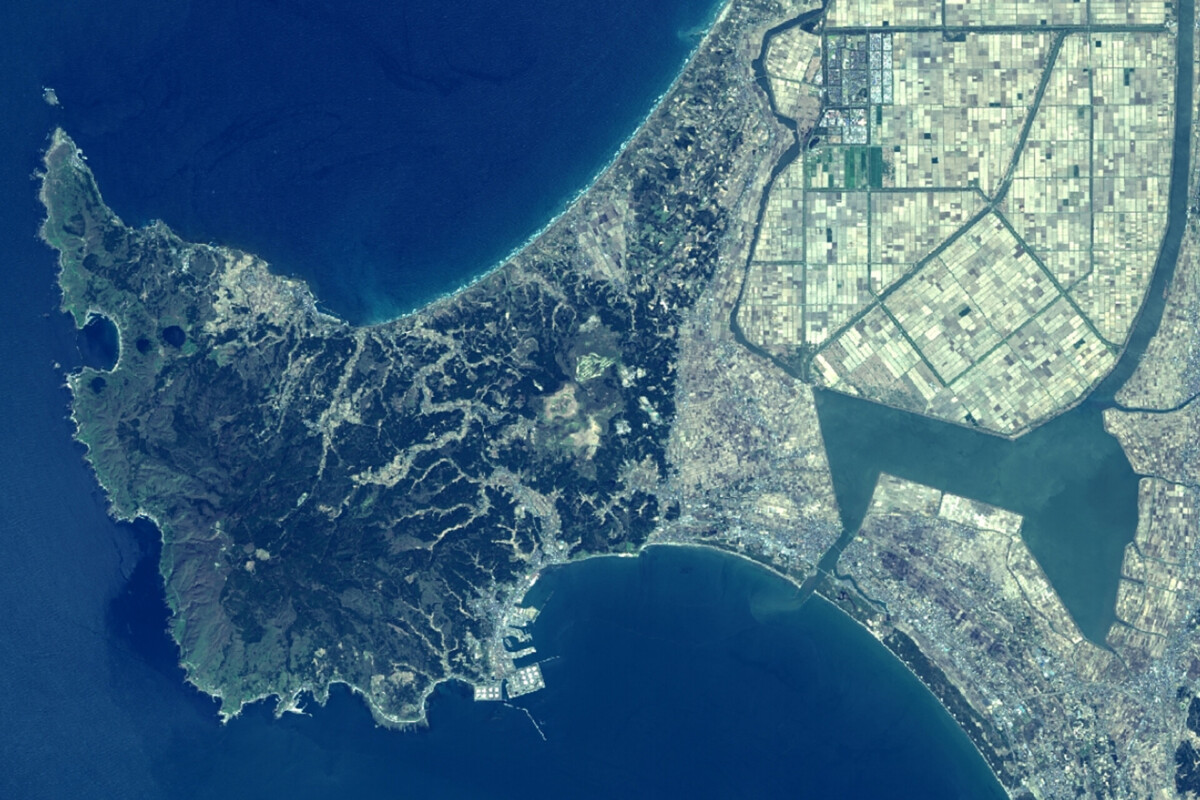
In any case, Ogashima's land area grew larger again, and the strait connecting it to the mainland narrowed and became shallower. In particular, a sand spit (a long, narrow mound made of sand carried by water currents) developed on the northern part of the island, where sand carried by the accumulated, and around 2,000 years ago, it became connected to the mainland.
Before reclamation, Hachirogata was the second largest lake in Japan
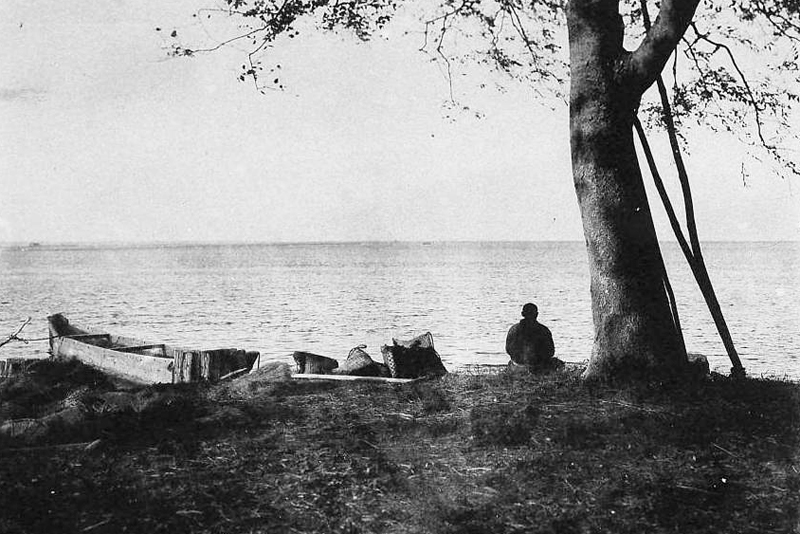
At that time, the southern part of the Oga Peninsula was not connected, and a very shallow sea stretched out. Eventually, the Omono River to the south (its mouth is in Akita City) spread, and the southern coastline became connected to land. At that time, the shallow inland sea was left behind and became a large lake (a brackish lake; a lake where fresh water and seawater mix). This Lake Hachirogata , the second largest lake in Japan after Lake Biwa. However, in 1977 (Showa 52), the opposite side of Lake Hachirogata was turned into land through reclamation in order to increase farmland, and there is little trace of the lake today. The site of Lake Hachirogata that was reclaimed as land was originally the bottom of the sea, so even today its elevation is below 0m.
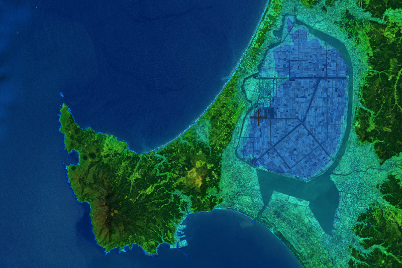
The Oga Peninsula, where the island is connected to the mainland by a sandbar, is known as a land-tied island the Oga Sanzan (Motoyama: 715m above sea level, Mt. Mayama: 565m, Mt. Kenashi 617m) and Mt. Kanpu (355m) known for its mountain lilies .
"Ichinomegata" is a national natural monument where water accumulates in the crater
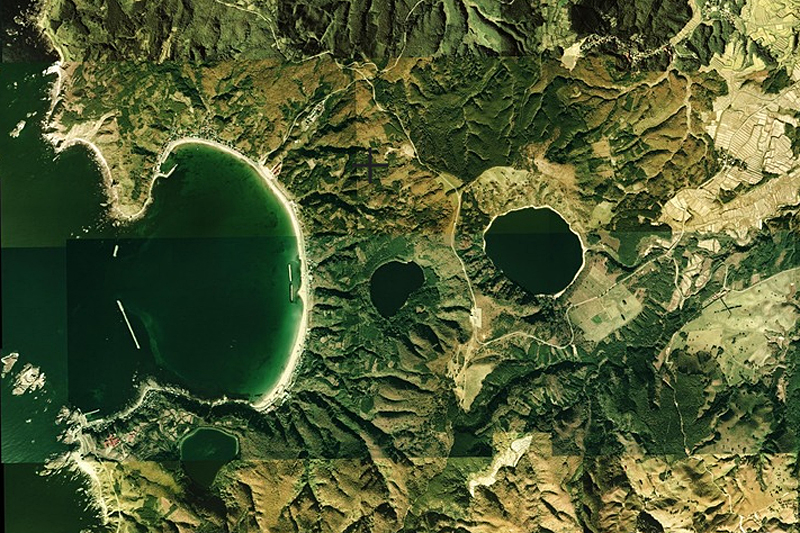
There are three round ponds near Toga Bay of the Oga Peninsula Ichinomegata, Ninomegata, and Ninomegata . All of these ponds were formed when water accumulated in explosion craters called maars. Ichinomegata is estimated to have been formed 60,000 to 80,000 years ago, Sannomegata 20,000 to 24,000 years ago, and Ninomegata somewhere in between.
Toga Bay is also semicircular and is a crater. It was formed by a phreatomagmatic explosion about 420,000 years ago, and the pumice that was ejected by the explosion is distributed on the high ground around the bay.
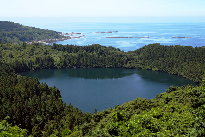
Hachimoudai a viewpoint on the Oga Peninsula , you can see Ninomegata below you, and if you look out to sea, you can see a panoramic view of Toga Bay. Ichinomegata is a national natural monument, and Sannomegata is a natural monument of Akita Prefecture.
The eastern side is sandy, while the rest of the coast is rocky
The Oga Peninsula was originally part of the Eurasian continent, but became the bottom of the sea before rising and emerging above ground. The land has been piled up over the 4.6 billion years since the Earth was born, creating various geological layers depending on the era in which it was formed. Many rocks with unusual shapes protrude from the western and southern coasts, each with different hardness and color, and upon investigation, some dating back as far as 90 million years have been found. The period 90 million years ago is known as the Cretaceous period, when dinosaurs roamed the land
The Oga Peninsula was inhabited during the Jomon period
It is not clear when people first began living on the Oga Peninsula, but the Yonegamori Ruins (Daisen City) have been discovered, which are thought to date back 15,000 to 35,000 years, so it is possible that people were living on the Oga Peninsula at that time. It is thought that people first came to the Japanese archipelago and began living there around 38,000 years ago, so people were here very early on.
The oldest ruins on the Oga Peninsula are the Ohatadai ruins , estimated to date back to the middle of the Jomon period, between 4,500 and 6,000 years ago. The Ohatadai ruins are located on the grounds of an oil refinery, near the southern base of the Oga Peninsula. As such, the ruins themselves are not open to the public, but excavated artifacts such as Jomon pottery and stone tools can be viewed upon request at the Oga City Historical Materials Repository (formerly Wakimoto Second Elementary School)
<Artifacts Excavated from the Ohatadai Ruins> INFORMATON
- Facility name: Oga City Historical Materials Storage (former Wakimoto Second Elementary School)
- Address: 156 Karisawa, Wakimoto, Oga City, Akita Prefecture
- Opening hours: 9:00-21:00
- Closed: December 29th to January 3rd
- access:
- Train: Approximately 50 minutes from Wakimoto Station on the JR Oga Line or approximately 7 minutes by taxi
- By car: Approximately 40 minutes from Showa Oga Peninsula IC on the Akita Expressway
GOOGLE MAP
The name Oga is derived from the name of the people who originally lived there
The most popular theory about the origin of the name Oga Peninsula is that it is a corruption of the Onga, the leader of the Emishi people who lived in Oga around the time Abe no Hirafu and his men were sent from the capital to conquer the Tohoku region known as Emishi , which was not under the control of the Yamato court during the Asuka period. Folklorist Kunio Yanagita (1875-1962) disagrees, arguing that the name was corrupted because Oga looks like land floating in the Sea of Japan.
In any case, there were so many deer living in Oga that there was a cliff called "Shishiotoshi" (Deer Fall) "Oga" were used to read "Onka" and "Riku
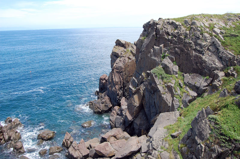
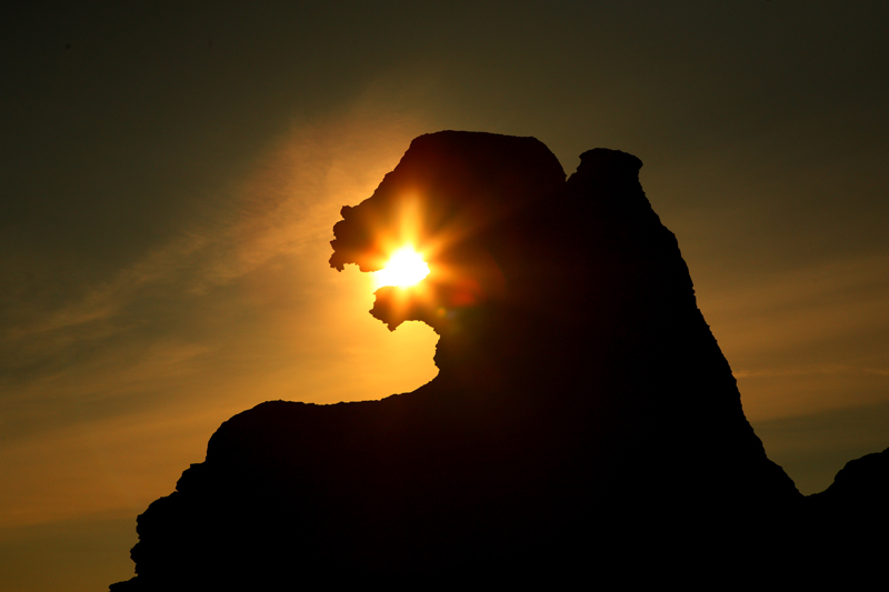
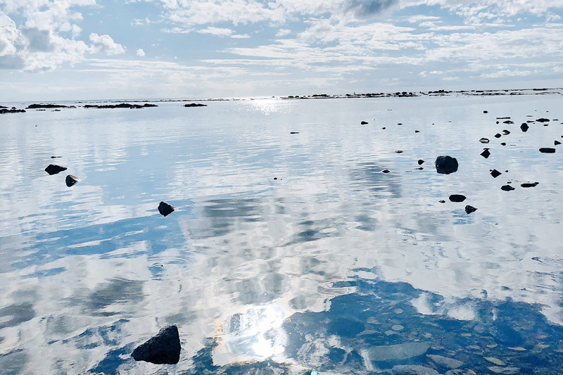
The Oga Peninsula is home to traditional cultures such as the Namahage, their ruins , and the Great Pier and Butaijima Island , as well as breathtaking views created by volcanoes like Ichinomegata Lagoon. It's also packed with sights and delicious food, including stone-grilled cuisine, sightseeing spots, and delicious food. Recently, Godzilla Rock, , and the photogenic Unosaki Coast, known as Akita's Uyuni Salt Flats, have become hugely popular on social media. Hot springs are also available. For sightseeing, the Oga Peninsula Ainori Taxi Namahage Shuttle from Oga Station on the JR Oga Line, sightseeing taxis, and rental cars are convenient. The Oga Peninsula is bursting with excitement, so why not visit?
<Oga Peninsula Sightseeing Tour> INFORMATION
- Facility name: Ainori Taxi Namahage Shuttle
- Operation period: April 1st to October 31st
- How to use: Reservation required
- Online/Applications must be made by 7:00 PM the day before
- Phone/Applications must be made by 5:00 PM the day before
- Number of people: 1 person and up
- Fare: Oga Station to Nyudozaki 2,500 yen (varies depending on other destinations)
- URL: Oga Peninsula Ainori Taxi Namahage Shuttle
- For route buses, please refer to the Oganavi Route Bus Timetable
- By car: It is convenient to take the Showa Oga Peninsula Interchange on the Akita Expressway
GOOGLE MAP
INFORMATION
- Oganavi
- URL: Oganavi



![[The History of Hachirogata Reclamation ③] The land is below sea level… Water management is a lifeline [Ogata Village, Akita Prefecture] The Southern Pumping Station almost completely blocks off the regulating reservoir (right) and the Western Receiving Channel (left). The long channel in the middle is the Central Main Drainage Channel. ©Oga Peninsula-Ogata Geopark](https://jp.neft.asia/wp-content/uploads/2024/07/WIA8xMbfFUTs8kQ1720954526_1720954532-150x150.jpg)
![Did Namahage really exist? Traces of demons remain throughout the Oga Peninsula - Oga Peninsula and Demon Legends (2) [Akita Prefecture] 1. Namahage Sedo Festival](https://jp.neft.asia/wp-content/uploads/2024/09/1076350e647a6476081bad8cd4fd6159-150x150.jpg)

![Why do Namahage carry blades and punish people? - Oga Peninsula and Demon Legends (1) [Akita Prefecture] New Year's Eve Event 001@OGA City](https://jp.neft.asia/wp-content/uploads/2024/10/00bf8a32651033edd1191ba2d04c6f61-150x150.jpg)
![[Part 3] Masumi Sugae's walk through the Oga Peninsula - hit by a major earthquake [Akita Prefecture] 1. The Cold Wind of Oga - Namahage Prefectural Museum](https://jp.neft.asia/wp-content/uploads/2024/10/7154afaf7fcdc00890442af025f9b4d1-150x150.jpg)
![[Oga Peninsula, Akita Prefecture] Strange rock formations on the west coast where ancient legends are passed down Rocky landscape on the west coast of the Oga Peninsula ©Oganavi](https://jp.neft.asia/wp-content/uploads/2024/04/8764aeda3bb4db1829041fa671d1b72d-150x150.jpg)
![[The History of Hachirogata Reclamation ①] Japan's second largest lake became a vast rice field [Ogata Village, Akita Prefecture] 7561d23df2a0ec24c664e184c3fc8d8f](https://jp.neft.asia/wp-content/uploads/2024/07/7561d23df2a0ec24c664e184c3fc8d8f-150x150.jpg)
