This site is an online media that delivers all sorts of trivia about the six Tohoku prefectures, from sightseeing and gourmet spots to local customs, history, and more
Based on "Oga no Gofu" (Five Winds of Oga) , a travelogue written by Edo period travel writer Sugae Masumi (1754-1829) about his journey through the Oga Peninsula, this book introduces the Oga Peninsula as seen through the eyes of Sugae Masumi, contrasting the Edo period with the present day .
The third installment is the final volume of the Oga Travelogue, "The Cold Wind of Oga," which begins on July 18, 1810 .
"The Cold Wind of Oga" details the author's feelings and the devastation around him during a historic earthquake
Masumi Sugae @Akita Prefectural Museum
This article will be written with reference to manuscripts from the Akita Prefectural Museum, the National Archives of Japan, the National Diet Library, and a modern translation published in 2000. Unless otherwise noted, dates from the Edo period are those recorded by Masumi (using the old calendar)
reference
Akita Prefectural Museum Sugae Masumi Library (Manuscript)
Published by Heibonsha, Sugae Masumi Travelogue 5, edited and translated by Uchida Takeshi and Miyamoto Tsuneichi, published on August 9, 2000
*The quotations from Masumi Sugae's writings are based on "Masumi Sugae's Travels, edited and translated by Takeshi Uchida and Tsuneichi Miyamoto, published by Heibonsha."
[The Cold Wind of Oga] Walking from west to east across the southern part of the Oga Peninsula
"Oga no Kanpu" (Cold Wind of Oga) follows "Oga no Shimakaze" (Island Wind of Oga), which ended on July 17, 1810, and begins on July 18th from Monzen (Motoyama Monzen, Funakawa Port, Oga City), located at the southwestern tip of the Oga Peninsula
"Camellia White Rock" which Masumi described as shaped like a maitake mushroom
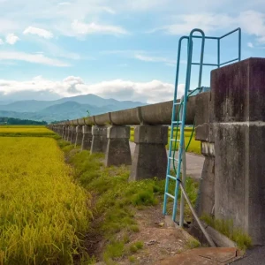
On the way from Monzen to Wakimoto (Wakimoto, Oga City), you will pass in front of a tall rock about 30 meters high that resembles a cloud rising up, at Tsubaki-no-ura (Tsubaki Fishing Port/Tsubaki, Funakawa Port, Oga City).
Masumi recorded this rock, which the guide explained to him as " Tsubaki no Shirasaki ," along with an illustration, in his work "Oga no Akikaze" (Autumn Wind of Oga)
"Camellia White Rock," which was called "Camellia White Rock" during the Edo period, was depicted by Masumi. From a manuscript of "Oga no Akikaze" (Autumn Winds of Oga) held at the National Archives of Japan
It seems it was raining then, and I wrote that "it was wet with rain and salt, its color was bluish, and it looked strange," but this time the weather was good and the rock was pure white, just as its name suggests
It is now called Tsubaki no Shiraiwa (Camellia White Rock ), but because Masumi described its shape as resembling a maitake mushroom , it is also known as "Maitake Rock."
"Tsubaki no Shiraiwa" is a volcanic tuff formed from volcanic lapilli ejected during volcanic activity approximately 21 million years ago. The round shape, which Masumi called "Maitake" (dancing mushroom), was naturally created by the weathering of the rock
In addition to white rocks, green rocks (green tuff) can also be seen scattered around the area. These are also a type of volcanic breccia tuff, just like the "Camellia White Rock," and their contents have turned green due to the influence of water heated by magma underground
Tsubaki no Shiraiwa <Information>
Facility name: Camellia White Rock
Location: Funakawa Port, Tsubaki, Oga City, Akita Prefecture
Phone number: 0185-24-4700 (Oga City Tourism Association)
Google Map
A large earthquake hits a village in the central part of the Oga Peninsula
On the same day, Masumi arrived in Wakimoto and went to Oibanasaki, where the ruins of the medieval Wakimoto Castle are located, and paid her respects at the Sugawara Shrine, dedicated to Sugawara no Michizane
From Wakimoto, I'll travel across the Oga Peninsula and stay at a friend's house in Ayukawa (Aikawa, Kitaura, Oga City) , located along the northern coast, until mid-August
On August 17th, the eerie anomalies continued. There was an earthquake. On the 18th, there was another earthquake strong enough to cause a temple pagoda to collapse
On August 25th (Masumi wrote September 25th, but it was a mistake and should have been August 25th), we headed back to Wakimoto to visit Sugawara Shrine, but the weather was bad so we spent the day in a village called Shimada (Oga Nakatakigawa Shimada, Oga City) on the way
Oga no Kanawazaki (Wakimoto no Ura), where Sugawara Shrine is located, is said to have been the site of the greatest damage caused by the Oga earthquake. Masumi had been painting this before the earthquake. From a manuscript of "Oga no Kanawaze" (Cold Winds of Oga) in the Akita Prefectural Museum
On August 27th, just as the weather had finally cleared up and she was about to go out, a major earthquake struck. Masumi described the events of that day as follows:
"The eaves and roofs tilted, and people fled in panic, crying and yelling as they grabbed the hands of the sick and elderly, some carrying babies upside down, and others ran around. "The beams fell with a terrible crash. Anyone standing would be knocked over, and the mountains of the eaves crumbled. Fearing for their lives, people clung to trees and fled to bamboo groves."
Aftershocks continued for days after the main earthquake, leaving villages on the southern coast in ruins
There were many aftershocks that day, and even two days later, on the 29th, the aftershocks accompanied by rumbling continued. The damage was particularly severe along the southern coast of the Oga Peninsula, including Wakimoto, where I had planned to go. In every village, there were no buildings left, and there were many casualties
As Masumi also wrote, the great earthquake that occurred at 2 PM on August 27, 1810 (September 25 in the solar calendar) had been preceded by frequent phenomena that could be considered precursors
laterthe Oga Great Earthquake (or Ugo Earthquake),had its epicenter off the coast of Wakimoto and a magnitude of 6.6. As Masumi wrote, "Kitaura on the northern coast of the Oga Peninsula suffered little damage," suggesting that the area affected was relatively small.
Nevertheless, records show that out of approximately 2,900 homes in the affected area, 1,400 collapsed and 58 people died, indicating significant damage
Although the depth of the epicenter is unknown, it is presumed to have been a shallow-focus earthquake. (Source: "1983 Japan Sea Central Earthquake: Records from Oga City," Oga City, Akita Prefecture)
This major earthquake has also brought about significant changes in the topography
Ikebanazaki, where the ruins of Wakimoto Castle and Sugawara Shrine are located, was reduced to its current form when the tip of the cape, approximately 700 meters long, collapsed
Six years before the Oga earthquake, the Kisakata earthquake occurred in Akita Prefecture, causing significant changes in the terrain
Masumi recalls a story about Kisakata Takujukushima , a famous scenic spot in Dewa Province ( present-day Akita Prefecture) that he visited when he was 30 years old (1784), which was buried by a major earthquake 20 years later in 1804.
The scenery of the Kisakata Ninety-Nine Islands has long been said to be as beautiful as Matsushima, and many people, including Matsuo Basho, have visited it as a tourist. However, a major earthquake in 1804 caused the land to rise by more than 2 meters, and the seabed around the Ninety-Nine Islands, which was shallow, became land overnight
Although Masumi did not leave any drawings of the tragic scenes after the Oga earthquake, he visited Wakimoto, which was close to the epicenter and suffered the most severe damage after the earthquake, and recorded in detail the tragic conditions there, leaving behind a valuable document for future generations as a record of the Oga earthquake
Wakimoto Castle Ruins <Information>
Facility name: Wakimoto Castle Ruins
Location: Wakimoto Nanasawa, Wakimoto, Oga City, Akita Prefecture 010-0342
Phone number: 0185-24-4700 (Oga City Tourism Association)
URL:
Google Map
Experience Namahage in a village in the northern part of the Oga Peninsula in January
In October, they spent some time in the village that had been hit by the earthquake, and with the support of the feudal domain, they resumed their journey once things had calmed down
I'll travel north along the base of the Oga Peninsula and spend about two months exploring the area around Lake Hachirogata
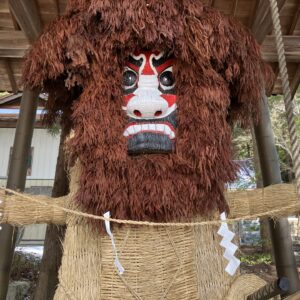
In 1811, the New Year was celebrated in Miyazawa Village (now Noishi, Oga City), located between Lake Hachirogata and the Sea of Japan. While enjoying the relaxed New Year's atmosphere,the Namahageappeared on the 15th.
A drawing of "Namahage" by Masumi. According to the caption, it was performed on January 15th during the Edo period. "The Cold Wind of Oga" (from a manuscript held at the Akita Prefectural Museum)
"Late in the evening, while the fire was lit and everyone was sitting in a circle around the hearth, suddenly a man wearing a vermilion mask with horns, with his jet-black hair disheveled, wearing a bamboo net and holding a small knife, burst in, crying "Wow!"
The children are shocked and say, "It's a namahagi (raw skinned fish)," and they don't make a sound but cling to people and hide in the shadows. When they are given rice cakes, they are threatened with, "Wow, it's scary, don't cry."
The word "namahage" is derived from the Japanese word "namahage," and while the characters might suggest something terrifying like "having your flesh peeled off," it actually refers to the brown bruises called"namomi", and the act of peeling these off.
Although the Namahage look like demons, they are actually visiting deities who admonish lazy people who spend their winter off-season warming themselves by the kotatsu or hearth, and pray for good health and a bountiful harvest
Namahage , known as " Oga no Namahage ," is designated as a National Important Intangible Folk Cultural Property. It is also listed on the UNESCO Representative List of the Intangible Cultural Heritage as one of the " Visiting Deities: Masked and Disguised Gods ."
I spent New Year's in Oga amidst snowfall from the 15th onwards, and finished "Oga's Cold Wind" on February 1st
The Oga Peninsula, where Masumi Sugae walked, has been equipped with 90 signposts and information boards for visitors to explore
The path that Sugae Masumi walked on the Oga Peninsula has been preserved as " Sugae Masumi's Path ," with marker posts at 83 locations that have some connection to him, and detailed explanatory signs at 8 locations
Please use this as a guide for exploring the Oga Peninsula
Link: Following the Oga Peninsula Walked by Masumi Sugae (3 Parts)
My love of travel led me to work for a travel magazine some time ago, and now I work as a travel writer for an online publication. I have visited all 47 prefectures in Japan, focusing on the Tohoku region, and I enjoy soaking in hot springs and experiencing traditional Japanese culture, including old townscapes, lifestyles, and performing arts and crafts


: Home to a morning market that has been running for over 500 years and the "zelkova tree with breasts"")