This site is an online media that delivers all sorts of trivia about the six Tohoku prefectures, from sightseeing and gourmet spots to local customs, history, and more
The Kurihara region, which makes up Kurihara City, is spread out at the southeastern foot of Mount Kurikoma, andthe Ichihasama River, Nihasama River, and Sanhasama River,, flow through it.
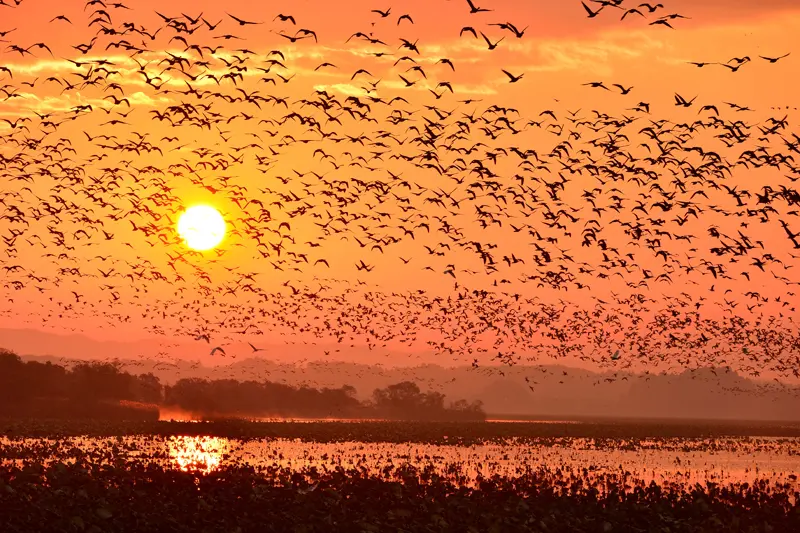
The river creates large wetlands in its lower reaches, and Izunuma and Uchinuma are known as "Japan's best birdwatching paradise ," attracting many geese and swans
After the wars of the Sengoku period, it became part of the territory of the Sendai domain during the Edo period
People have lived in the Kurihara region since the Paleolithic period, and many ruins have been discovered there. From the Middle Ages onwards, many villages were scattered around the area, and powerful clans emerged to rule over the villages, leading to a period of warring factions. During the Sengoku period, the area came under the control of the Kasai clan, but there were constant internal conflicts with the Tomizawa clan, who were descended from the Kasai clan, and with the neighboring Osaki clan
In the Kurihara region, many castles (or mansions/see Kurihara City Cultural Properties) were built by powerful local families from the Kamakura period to the Muromachi period, but now only ruins remain, and details are unknown. Among them,Tsurumaru Castle in Iwagasaki (Kurikoma Iwagasaki)was built by the Tomizawa clan during the Sengoku period and later functioned as a branch castle of the Date clan (Sendai Domain).
Kurihara was a place where many post stations were established along the Oshu Highway. The main inn was located in Arikabe
During the Edo period, the Oshu Highway ran north-south through Kurihara, and post stations were established along the highwayTakashimizu,Tsukidate,Miyano, Sawabe, Kannari, andArikabe. Tsukidate-juku, in particular, was a bustling post station as it was the junction with the highway leading to the Akita Domain (present-day National Route 398), and Arikabe-juku had a main inn (a nationally designated historical site).
To head towards the Akita domain, one would head north along the western foot of Mount Kurikoma and enter Akita Prefecture at Hanayama Pass, but just before the pass there was a checkpoint called the Sendai Domain Hanayama Village Nuruyu Bansho to inspect travelers and their luggage
During the Heisei Great Merger, 10 towns and villages merged to form Kurihara City
During the Meiji era, Kurihara became Kurihara Prefecture, and in 1876 (Meiji 9), it was incorporated into Miyagi Prefecture. Later, the area including parts of present-day Osaki City and Tome City became Kurihara District, and in 2005 (Heisei 17), the 10 towns and villages that belonged to the then Kurihara District — IchihasamaTown , Uguisuzawa Town, Kanari Town, Kurikoma Town, Shiwahime Town, Semine Town , Takashimizu Town , Tsukidate Town , Wakayanagi Town , and Hanayama Village — merged to form the present-day Kurihara City, and Kurihara District ceased to exist.
Tsurumaru Castle, which managed the Kurihara area as a subsidiary castle (fort) of the Sendai domain
Tsurumaru Castleis unknown, but it is said to have been built during the Sengoku period by the Tomizawa clan, a branch of the Kasai clan who ruled the Kurihara area. It was built on a small hill in what is now Kurikoma Iwagazaki and was a large structure, measuring approximately 650m east-west and 400m north-south.
Tsurumaru Castle came under the control of the Sendai Domain, and Masamune Date placed great importance on the castle, with his fifth son, followed by his sixth son, becoming the castle's lord. After the One Castle per Province Order was issued, the castle was nominally demoted to a fortress, but until the end of the Edo period, senior vassals of the Sendai Domain served as castle lords, and the castle continued to play an important role as a defense against foreign enemies such as the Akita Domain, and as a branch office of the Sendai Domain
Currently, the area around the Tsurumaru Castle ruinsKurikoma Tateyama Park, a public park where visitors can enjoy the beauty of the four seasons, including the cherry blossoms in spring, and admire the majestic Mount Kurikoma.
Kurikoma Tateyama Park <Information>
Facility name: Kurikoma Tateyama Park
Address: Tateyama Park, 93-1 Kurikoma Iwagasaki Urayama, Kurihara City, Miyagi Prefecture
Phone number: 0228-25-4166 (Kurihara City Tourism and Products Association)
Free walk
access:
Train: Take the city bus bound for Kurikoma from Ishigoe Station on the JR Tohoku Main Line on the Kurihara Denen Line for approximately 37 minutes, then get off at the Kurikoma bus stop and walk for approximately 15 minutes
By car: Approximately 30 minutes from Wakayanagi Kanari IC on the Tohoku Expressway via the Nakata Kurikoma Prefectural Road
Google Map
The retro shopping street "Kurikoma Muikamachi Street Shopping District" is attracting attention again
Iwagazaki, where Tsuruga Castle once stood, saw the opening of the Kurihara Railway (later the Kurihara Rural Railway) in 1922 (Taisho 11).Furtherextension to the Hosokura Mine in 1942 (Showa 17)made it a bustling town playing a vital role in logistics in northern Kurihara. In 1955 (Showa 30), it merged with several surrounding villages, including Kurikoma Village, to form Kurikoma Town.
However, Kurikoma Town rapidly declined with the closure of the Hosokura Mine in 1987 (Showa 62), and the once bustling shopping district became deserted
Then, more than 30 years later, a cafe opened in the forgotten Rokkamachi shopping street . Coinciding with the retro boom that was popular nationwide at the time, tourists began to visit little by little. This led to people starting businesses in the town, and combined with the activities of the town revitalization cooperation team, the shopping street began to attract attention as a place where something interesting might happen
Muikamachi Shopping Street <Information>
Facility name: Muikamachi Street Shopping District
Location: Kurikoma Iwagasaki Muikamachi, Kurihara City, Miyagi Prefecture
Phone number: 0228-45-2191 (Kurikoma Uguisuzawa Chamber of Commerce and Industry), 0228-24-7871 (Muikamachi Regional Revitalization Cooperation Team Office)
Train: Take the city bus bound for Kurikoma from Ishigoe Station on the JR Tohoku Main Line on the Kurihara Denen Line for approximately 37 minutes and get off at the Kurikoma bus stop
By car: Approximately 20 minutes from Wakayanagi Kanari IC on the Tohoku Expressway via the Nakata Kurikoma Prefectural Road
Google Map
The former Arikabe Inn, where buildings from the mid-Edo period remain and retain their original appearance
Arikabe-juku was founded in 1619 as a post station on the Oshu Kaido road, and for generations the Sato family managed the town officials and the main inn. The main inn served as lodging for feudal lords and senior vassals of the Matsumae and Nanbu domains during their alternate attendance periods
The existing main inn building was renovated in 1744 and is a valuable structure that retains the appearance of the time. The main gate used by the feudal lord has not been opened since Emperor Meiji entered and exited in 1881 (Meiji 14), and is still closed to the public. The former Arikabe-juku main inn is designated as a national historic site and a tangible cultural property of Miyagi Prefecture
Arikabe Honjin <Information>
Facility name: Arikabe Honjin (Miyagi Prefecture Intangible Cultural Property)
Address: 31 Kanari Arikabe Honcho, Kurihara City, Miyagi Prefecture
Visit: Free to view the exterior only
access:
Train: Approximately 5 minutes on foot from Arikabe Station on the Tohoku Main Line
By car: Approximately 15 minutes from Wakayanagi Kanari IC on the Tohoku Expressway
Google Map
One of the few remaining guard posts: the remains of the Sendai Domain's Hanayama Village Kanyu Guard Post
The site of the Kanyu checkpoint in Hanayama Village, Sendai Domain, was a checkpoint (barrier station) established by the Sendai Domain at the border with the Akita Domain. To travel from the Sendai Domain to the Akita Domain, one had to cross the Hanayama Pass, which is 741m above sea level and was known as the "Hanayama Pass." The Sendai Domain established a checkpoint before the pass to strictly control entry and exit. Checkpoints established at the domain border are called "kuchidome bansho" or "sakaime bansho," and this site is a valuable example of one that still retains its original form, and has been designated a "National Historic Site."
"Kanyu" refers to a hot spring that was located near the guardhouse, and is now a warm hot spring
Kanyu Guardhouse Ruins <Information>
Facility name: Sendai Domain Hanayama Village Cold Bath Guard Station Ruins
If you visit Kurihara City, you should definitely stop by"Izunuma and Uchinuma".
Izunuma and Uchinumaare the largest lakes in Miyagi Prefecture, spanning Kurihara City and Tome City, with a combined area of 491 hectares (Izunuma 369 hectares, Uchinuma 122 hectares). A key characteristic is their shallow depth, averaging 80 cm and reaching a maximum of 1.6 m. Aquatic plants thrive even in the center of the lakes, providing a habitat for numerous insects and birds.
In particular, it serves as a wintering ground for geese, ducks, and swans that migrate from Russia in the autumn and winter . Tens of thousands of greater white-fronted geese and more than 2,000 whooper swans migrate here, making it the largest number in Japan. Izunuma, Uchinuma, and the surrounding rice paddy areas are designated as Ramsar Convention wetlands , and efforts are being made to protect the environment
Izunuma and Uchinuma <Information>
Facility name: Izunuma and Uchinuma
Address: 17-2 Kamihataoka Shikimi, Wakayanagi, Kurihara City, Miyagi Prefecture, and other locations
Phone number: 0228-25-4166 (Kurihara City Tourism and Products Association)
access:
Train: Approximately 10 minutes by car from Kurikoma-Kogen Station on the Tohoku Shinkansen
By car: Approximately 10 minutes by car from Tsukidate IC on the Tohoku Expressway, or approximately 20 minutes by car from Wakayagi Kanari IC
My love of travel led me to work for a travel magazine some time ago, and now I work as a travel writer for an online publication. I have visited all 47 prefectures in Japan, focusing on the Tohoku region, and I enjoy soaking in hot springs and experiencing traditional Japanese culture, including old townscapes, lifestyles, and performing arts and crafts


")

")
")


