Learning from large-scale landslides at Mount Kurikoma Geopark (Miyagi Prefecture)
table of contents
- 1 Large-scale landslides caused by Iwate-Miyagi inland earthquake
- 2 The Ou Mountains, where Mount Kurikoma is located, are the newest mountain range in the history of the Earth
- 3 The foot of Mount Kurikoma is a valuable geopark where you can learn about the Earth's activities
- 4 The view from the summit is spectacular. Mount Kurikoma is relatively easy to climb
- 5 Climbing is restricted near Lake Showa, where a large amount of toxic gas is being emitted
- 6 The greatest highlight of Mount Kurikoma is the vibrant autumn foliage that covers the entire mountain
- 7 Day lilies dye the World Yachi Primeval Flower Garden yellow
- 8 Hosokura Mine, where minerals were produced by volcanic activity on Mount Kurikoma
Mount Kurikoma is a 1,626m-high volcano located on the border between Miyagi, Iwate, and Akita prefectures. In Iwate Prefecture, it is also known as Mount A small steam eruption in 1944 formed Lake Showa in the crater crater on the mountainside.
Large-scale landslides caused by Iwate-Miyagi inland earthquake
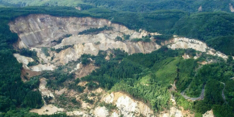
The most devastating earthquake was the Iwate-Miyagi Inland Earthquake of 2008 (Heisei 20). The earthquake occurred on June 14th, with an epicenter about 10km northeast of Mount Kurikoma, a depth of 8km, and a magnitude of 7.2, and recorded a maximum seismic intensity of 6+. This earthquake caused a large-scale landslide at the foot of Mount Kurikoma on the Miyagi side, resulting in a disaster that caused great human casualties.
In the Iwate-Miyagi inland earthquake, over 3,500 large and small slope movements were confirmed on the fault that caused the earthquake. In particular, the landslide that occurred upstream of the Aratozawa Dam was massive, measuring 1,300m in length, 900m at its widest point, and 150m in height, with the amount of soil and sand that slid down (unstable soil volume) reaching 67 million cubic meters, equivalent to the volume of 54 Tokyo Domes.
The Ou Mountains, where Mount Kurikoma is located, are the newest mountain range in the history of the Earth
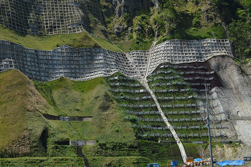
The Aratozawa landslide and other numerous other slope movements are said to be due to the formation of the Ou Mountains. The Ou Mountains are a chain of watersheds in the Tohoku region (backbone mountain range), and are the newest mountain range in the world. The ground that was under the sea rose up, and various sediments from subsequent volcanic activity and other factors piled up on top of that old ground, forming a mille-feuille-like layer of rock. The ridge of Mount Kurikoma is a layer of rock that meets all of these conditions, and a massive earthquake with short, small shaking over a short period of time caused a landslide like an avalanche.
Many of the landslides, from the large one that occurred in Aratozawa to the small ones, have occurred in areas where people live, and recovery efforts are still ongoing even now, more than 15 years later
The foot of Mount Kurikoma is a valuable geopark where you can learn about the Earth's activities
Kurihara City, Miyagi Prefecture, including the area where the landslide occurred, has been certified as the Mount Kurikoma Geopark. Geoparks are parks created by the Earth. Not only do they provide dynamic natural playgrounds, but sometimes, like Mount Kurikoma, they also unleash challenging battles without warning on places where people have been living peacefully. One of the roles of a geopark is to conduct research and learn how to overcome these challenges. Activities are also underway to use this landslide as an important teaching material for learning about the Earth. The Aratozawa landslide area has been selected as one of Japan's "Top 100 Geological Sites" as the "upstream collapse area of the Aratozawa Dam."
The view from the summit is spectacular. Mount Kurikoma is relatively easy to climb
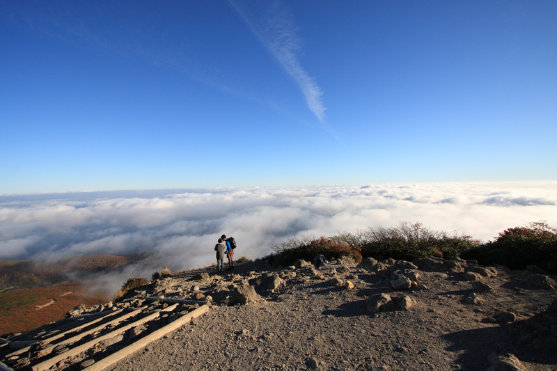
There are nine hiking trails to the summit of Mount Kurikoma, and they can be enjoyed by hikers of all levels, from beginners to advanced climbers. The trails are well maintained, and there are parking lots, washrooms, day-trip hot springs, and accommodation facilities at the trailhead, so you can rest assured. Day hikes are possible, but as it is within a quasi-national park, camping is prohibited. Please note that there are no mountain huts where you can stay overnight along the trails.
Mount Kurikoma is still an active volcano, with areas of intense fumarolic activity near the summit. It is a volcano under constant observation by the Japan Meteorological Agency, so caution is advised
Climbing is restricted near Lake Showa, where a large amount of toxic gas is being emitted
As of July 2023, the northern Sukawa hiking trail is partially closed due to volcanic gases such as hydrogen sulfide erupting near Lake Showa. The hiking trail from the base of the mountain to Lake Showa is open for a certain period in the fall. (Please inquire.)
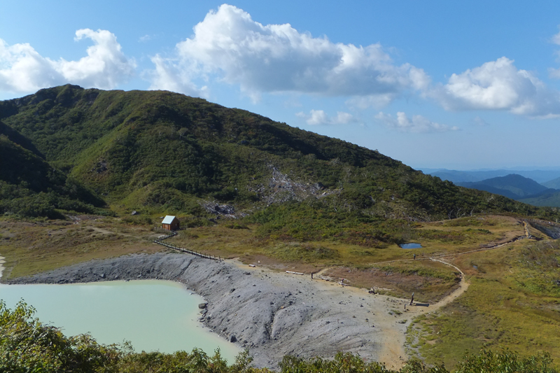
Lake Showa is a small lake formed during a small eruption in 1944. It is a crater lake formed when water accumulated in the area where the crater was. The water is highly acidic and milky white.
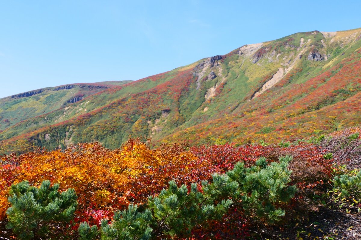
The greatest highlight of Mount Kurikoma is the vibrant autumn foliage that covers the entire mountain
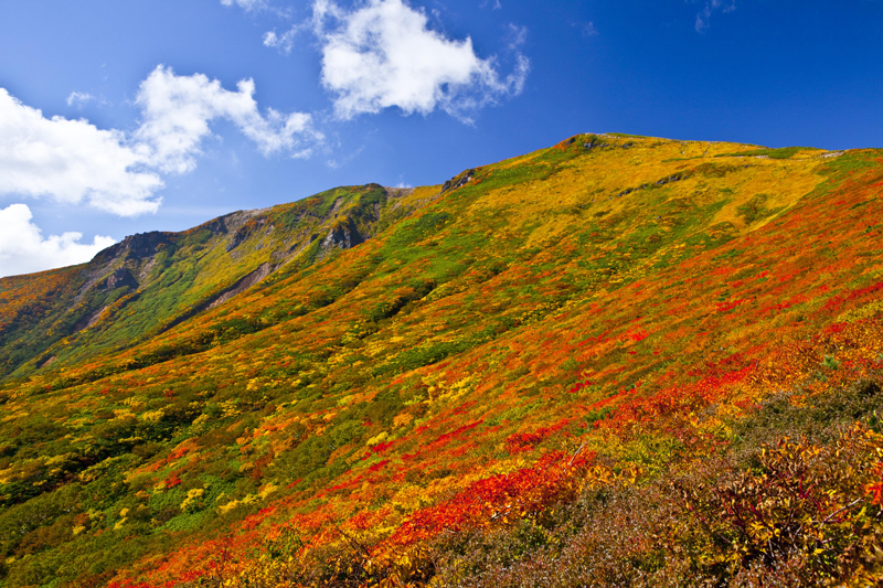
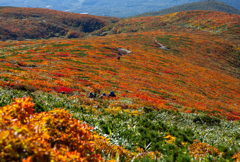
The slopes of Mount Kurikoma are a popular spot for viewing autumn leaves, and many tourists visit. Around Iwakagami-daira, the trailhead leading from the Mount Kurikoma Geopark side to the summit, there is even an autumn-only bus route that runs to allow visitors to view the autumn leaves all the way to the summit. During the autumn foliage season, private cars can only go as far as the Ikoi-no-Mura Kurikoma Former Site Parking Lot. A shuttle bus will take you from the Ikoi-no-Mura Kurikoma Former Site Parking Lot to the Iwakagami-daira Parking Lot.
The trailhead, Iwakakamidaira, is at an elevation of 1,113m, and there are two routes to the summit from there. The central route is the shortest of the hiking trails at 2.9km to the summit, and is a well-maintained path with a gentle gradient, making it perfect for beginners. There are almost no dangerous spots, and a leisurely round trip can be completed in about three hours. There is the Kurikoma Rest House at Iwakakamidaira, which has a shop, restaurant, toilets, and more, and the sturdy reinforced concrete building can be used as an emergency shelter
Kurikoma Rest House <Information>
- Facility name: Iwakagamidaira trailhead and Kurikoma Rest House
- Location: Kurikomanumakurakoeihigashi, Kurihara City, Miyagi Prefecture
- Phone number: 0228-43-4100
- Business hours: 9:00-17:00
- access:
- Train: Approximately 1 hour by car from Kurikoma-Kogen Station on the Tohoku Shinkansen
- By car: 50 minutes from Kannari Wakayanagi IC on the Tohoku Expressway
- * During the autumn season (early to late October), on weekends and holidays, the route bus "Kurikomayama Autumn Leaves" runs from Mikurikoma Kogen Station one round trip per day (for operating periods and times, please see the Miyako Bus website
- URL: Miyako Bus (Miyagi Kotsu)
- URL: Kurikoma Rest House
Google Map
Day lilies dye the World Yachi Primeval Flower Garden yellow
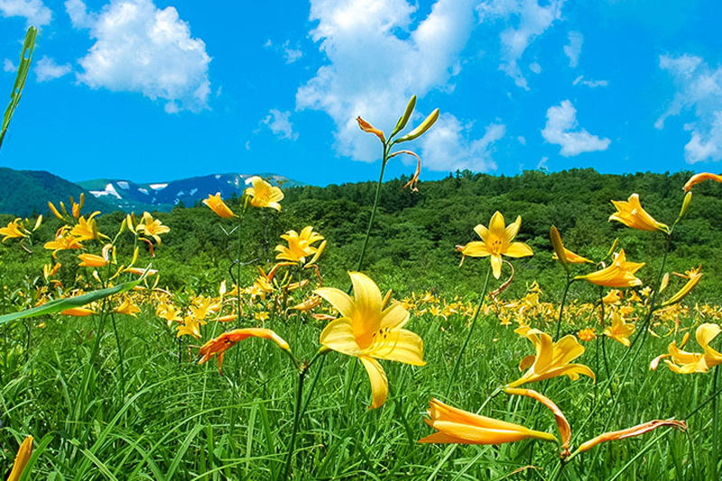
Sekai Yachi Primeval Flower Garden is a long, narrow marshland that spreads across a plateau at an altitude of around 700m, covering an area of approximately 14 hectares, or roughly the size of three Tokyo Domes. Sekai Yachi means "wide marshland," and it consists of eight large and small marshes in four groups that are divided into three tiers: upper, middle, and lower.
At the Sekai Yachi Primeval Flower Garden, a variety of marshland flowers bloom in competition with one another, from Asian skunk cabbage in May to Siberian gentian in September. In particular, the large colonies of day lilies that bloom in late June are spectacular, painting the entire marshland a vibrant orange hue
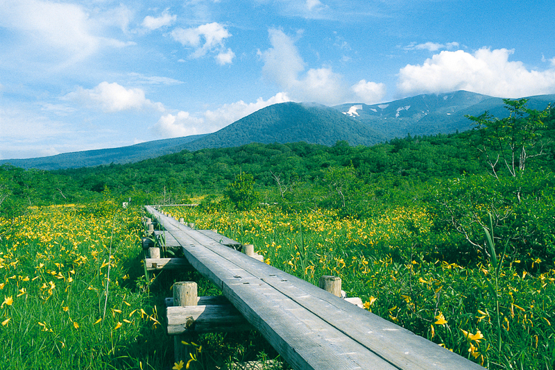
The marsh can be reached in about 15 minutes on foot from the designated parking lot, and is popular as a marsh that anyone can visit
World Valley Primeval Flower Garden<Information>
- Facility name: World Yachi Primeval Flower Garden
- Location: Kurihara City, Miyagi Prefecture, Kurihara City, Miyagi Prefecture, Kurikomanumakurakoeiminami
- Free to wander around
- access:
- Train: Approximately 1 hour and 10 minutes by car from Kurikoma-Kogen Station on the Tohoku Shinkansen
- By car: Approximately 1 hour from Wakayanagi Kanari IC on the Tohoku Expressway
Google Map
Hosokura Mine, where minerals were produced by volcanic activity on Mount Kurikoma
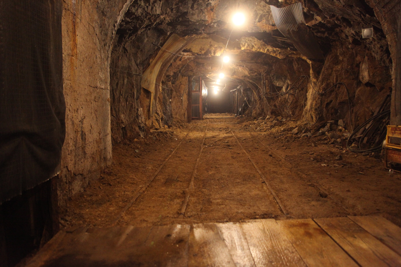
Hosokura Mine was discovered at the foot of Mt. Kurikoma approximately 1,100 years ago and is a silver and lead producing mine that continued to be mined until 1987 (Showa 62). During the Edo period, the Date Domain put a lot of effort into the mine, and mining continued thereafter, with periods of ups and downs, until 1987 (Showa 62). It was war that transformed Hosokura Mine into one of Japan's leading mines. In particular, World War I, which broke out in 1915 (Taisho 4), increased military demand for lead and zinc. That was until World War II, when a decline in demand for lead and other metals forced the mine to close.
The Hosokura Mine's mineral deposits are called "hydrothermal deposits," and the volcanic activity of Mount Kurikoma plays an important role. Hot water deep underground, heated by magma, rises to the surface, absorbing various metal ions from the rocks in its path. These ions crystallize due to environmental changes along the way, such as pressure and chemical reactions, and precipitate in cracks in the rocks. The minerals that accumulate in the cracks are called veins, and they contain many useful metallic minerals such as gold, silver, copper, lead, zinc, and tin. These veins are called "hydrothermal deposits," and the Hosokura Mine's mineral deposits are exactly such "hydrothermal deposits."
After the Hosokura Mine closed, it was reborn in 1990 Hosokura Mine Park . In Adventure Zone, visitors can also enjoy historical exhibits and scenes of work at the Hosokura Mine, as well as gold panning and an exhibit that imagines the mine tunnels as a space for the creation of space, making it a place of learning. In Slider Park, visitors can take an aerial stroll on a gondola to the top and a thrilling 555m slide to the bottom. From the observation deck, visitors can enjoy a magnificent panoramic view of the foot of Mt. Kurikoma.
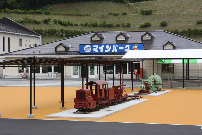
Hosokura Mine Park <Information>
- Facility name: Hosokura Mine Park
- Address: 2-3 Yanagisawa, Uguisuzawa Nango, Kurihara City, Miyagi Prefecture
- Phone number: 0228-55-3215
- Opening hours:
- March to November: 9:30 to 17:00
- December to February: 9:30 to 16:00
- Closed: Tuesdays (or the following day if it is a public holiday), New Year's holidays
- *Open during Golden Week and summer vacation
- Admission fee:
- Tourist mine viewing: Adults 500 yen, Junior and senior high school students 400 yen, Elementary school students 300 yen
- Gold panning experience: Adults, junior and senior high school students: 500 yen, elementary school students: 400 yen
- access:
- Train: Approximately 40 minutes by car from Kurikoma-Kogen Station on the Tohoku Shinkansen
- By car: Approximately 35 minutes from Tsukidate IC on the Tohoku Expressway, approximately 30 minutes from Wakayagi Kanari IC
- URL: Hosokura Mine Park



![[Iwate Prefecture] 7 Famous Waters in Iwate Prefecture! Sweetfish and salmon swim upstream in the famous waters that flow through the city! Kanazawa Shimizu](https://jp.neft.asia/wp-content/uploads/2023/01/04c0e41c5c967dc6dff186747fcc80df-150x150.jpg)

![From Kurozuka Cave to Bunchi Suriishi. Matsuo Basho visits the legendary rock formations [Fukushima Prefecture] 2016_07_MG_7167](https://jp.neft.asia/wp-content/uploads/2022/11/2016_07_MG_7167-150x150.jpg)
![[Miyagi Prefecture] 3 Recommended Hot Springs in Miyagi Prefecture Selected for Their Hidden Hot Springs, Famous Hot Springs, and Unique Spring Quality! Ichinobo 1 Official Website](https://jp.neft.asia/wp-content/uploads/2024/01/78ca4f579aa2c9ae226b88b519c3bac4-150x150.jpg)
![Togatta Kokeshi - Traditional Kokeshi Dolls Developed in Miyagi Zao's "Togatta Onsen" [Miyagi Prefecture] The facial expressions of Togatta Kokeshi dolls](https://jp.neft.asia/wp-content/uploads/2024/09/IMG_1784-150x150.jpg)


