This site is an online media that delivers all sorts of trivia about the six Tohoku prefectures, from sightseeing and gourmet spots to local customs, history, and more
Mount Bandai (located in Inawashiro Town, Bandai Town, and Kitashiobara Village, Fukushima Prefecture) is one of Japan's leading active volcanoes, consisting of three peaks : Mount Bandai (Oobandai, 1,816m), Mount Kushigamine (1,636m), and Mount Akahani (1,430m)
Omotebandai and Urabandai were formed by an eruption during the Meiji period
Mount Bandaioriginally had a beautiful shape similar to Mount Fuji, buton July 15, 1888 (Meiji 21), at around 7:45 a.m., it erupted with a loud roar, and in a short period of time it erupted nearly 20 times, causing most of Mount Kobandai to collapse.
When you view Mount Bandai from the north, the large gouges left by the collapse are clearly visible, vividly demonstrating the terrifying power of Earth's activity
On the other hand, when viewed from the south side, where Lake Inawashiro is located, the collapsed section is not visible, making it appear as a beautiful stratovolcano with a well-defined ridgeline
This tranquil view is called Omote-Bandai (Front Bandai), while the rugged landscape on the opposite side is called Ura-Bandai (Back Bandai)
Despite its appearance, Mount Bandai is a relatively docile volcano
Mount Bandai is often thought to be an active volcano because it has experienced large-scale landslides, but in recorded history, it has only erupted significantly twice, in 806 and 1888 , and even those eruptions were of moderate scale (according to data from the Japan Meteorological Agency).
In 1888, a series of rapid, rapid phreatic eruptions caused the mountain to collapse, but it did not scatter large amounts of volcanic rocks and ash over a wide area like Mount Fuji or Mount Asama
Nevertheless, multiple volcanic earthquakes have occurred since 1888. Most recently, the number of volcanic earthquakes has increased significantly since November 2022, prompting the Japan Meteorological Agency to issue a warning that utmost caution is necessary
"Illustration of the eruption of Mt. Bandai in Iwashiro Province" depicting the 1888 eruption. Collection: University of Tokyo
From the perspective of Earth's history, it is believed that Mount Bandai experienced a major eruption involving a collapse of the mountain 30,000 to 50,000 years ago, and that Lake Inawashiro was formed at that time
Recent research has led to the strong belief that the eruption causedthe summit, which was higher than Mount Fuji,to collapse, and that the resulting mudflow dammed the rivers at the foot of the mountain, forming Lake Inawashiro.
Later, a new volcano was born within the caldera (crater floor) that formed at the summit, and it grew into the present-day Mount Bandai (also known as Mount Aizu Fuji or Mount Obandai)
The collapse of the mountain in the Meiji period created many large and small lakes, including Lake Hibara and Lake Goshikinuma
The 1888 eruption caused great damage to the village at the foot of the mountain and created large and small lakes and marshes. "A Picture of the Eruption of Mt. Bandai" Illustration: Toyokuni Collection: National Diet Library
The 1888 eruption caused collapsed earth and debris to dam rivers, creating numerous lakes and marshes in the Ura-Bandai area
It is said that there are more than 300 of them, ranging from large lakes like Lake Hibara and Lake Onogawa to areas like Goshikinuma , where small ponds are scattered across a narrow region.
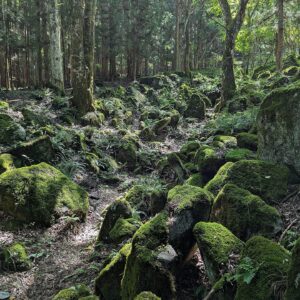
"Dounuma" where the scars of a mountain collapse remain vividly
Akanuma is a crater lake where you can see the remnants of the 1888 landslide up close . It is located at an altitude of 1,120m
"Dōnuma" (Copper Swamp) is filled with clear, highly acidic water containing metal ions such as iron, aluminum, and manganese. However, it was named "Dōnuma" because the reddish, iron-rich mud that has accumulated at the bottom is visible through the water
Steam rises from the reddish-brown rocks around the swamp, and rugged cliffs with vivid traces of collapses loom close behind. The scenery really makes you realize that Mt. Bandai is an active volcano
The route to Donuma is about an hour's hike one way, and proper equipment is required
Lake Hibara, the largest lake in Urabandai and a tourist hub
Lake Hibarais a lake formed when a river was dammed up by a volcanic eruption in 1888.
at an altitude of approximately 822m, with a shoreline of about 31km and a maximum depth of about 31m, it is the largest lake in Urabandai and also the largestvolcanic dammed lake in Japan. Situated in the heart of Urabandai, it is easily accessible and serves as a base for sightseeing in the area.
Hibara originally flourished as a post town on the old Yonezawa Road from the Sengoku period to the Edo period. However, the town was submerged under the lake by the eruption of 1888
Evidence of this can be seen in the approach to the Oyamazumi Shrine and its torii gate, which emerge from the lakebed during periods of drought
Lake Onogawais located at an altitude of approximately 797m and has a circumference of about 10km. Its source is a large waterfall called Onogawa Fudo Falls, with a drop of about 25m and a width of about 15m, and water overflowing from Lake Hibara also flows into it.
Onogawa Fudo Falls is a beautiful waterfall that flows through deep greenery, but it is especially spectacular when it cascades down into a snowy landscape during the harsh winter months. The lake is rich in nutrients and is a mecca for smelt and bass fishing, attracting many anglers
Lake Akimotois located east of Lake Onogawa, at an altitude of approximately 736m and with a circumference of about 20km. It is the second largest lake in Urabandai. It was formed in 1888 when the Nagase River, which flows out of Lake Onogawa, was dammed by an eruption.
Located quite far from Lake Hibara, the main tourist area, this spot doesn't attract many tourists. However,ice fishing for smelt fromis extremely popular among fishing enthusiasts.
Lake Sohara is a small lake with a circumference of 3.5km, perfect for a stroll
Sohara Lakeis a small lake with a circumference of approximately 3.5 km, located about 150 meters east of Hibara Lake.
It is the fourth largest lake in Ura-Bandai and is located at an altitude of approximately 830m, slightly higher than Lake Hibara. The water is slightly cloudy and brownish, which is due to the decomposition of fallen leaves from the surrounding broadleaf trees. There is plenty of plankton and aquatic plants, and many wild birds visit the lake. Walking trails are maintained around it
The "Goshikinuma" (Five-Colored Ponds) are a beautiful spectacle of mystical swamps displaying a variety of colors and expressions
The 1888 eruption of Mount Bandai created several large dammed lakes, such as Lake Hibara and Lake Akimoto, but it also formed hundreds of smaller ponds and marshes in this area. There are more than 30 such marshes clustered together on the western shore of Lake Hibara. The water in each of them has a subtly different hue, and they are known as the "Goshikinuma (Five-Colored Marsh) Lake Group."
The water in the Goshikinuma Lakes is connected to groundwater from Dounuma Lake, which contains a large amount of hydrogen sulfide (sulfate ions). When the groundwater reaches the surface, these two types of water mix together, causing a subtle change in water quality and resulting in the lakes appearing to have different colors
Located at an altitude of 780m to 815m in relatively flat terrain, the area is connected by walking trails. TheGoshikinuma Nature Trailis approximately 4km long and can be safely walked by families during the green season (in winter, snowshoes or similar equipment are necessary due to the snow).
The Goshikinuma Nature Trail has two entrances, one on the Hibara Lake side and one on the Bishamon Lake side, and each has an information center, bus stop, and parking lot
Among the "Goshikinuma Lakes," the most famous are"Aonuma," "Rurinuma," and "Bishamonnuma.
Aonuma Pondis located about 1km from the entrance to the Goshikinuma Nature Trail on the shore of Lake Hibara, and can be reached in about 15 minutes. The water is clear, but on sunny days it turns a beautiful, translucent blue color.
Rurinuma Pondis located very close to Aonuma Pond and shines with a blue hue. Its color is subtly different from Aonuma Pond, making it visually striking.
Bishamonnumais the largest of the Goshikinuma lakes. The observation deck is about 400m from the entrance on the Bishamonnuma side. The water is a slightly cloudy bluish-green, and it is a scenic lake with Mount Bandai visible in the distance.
Goshikinuma Nature Trail<Information>
Facility name: Goshikinuma Nature Trail
Total length: approx. 4km
Travel time: 1 hour 10 minutes to 1 hour 30 minutes one way
Difficulty: Beginner
Entrance to Urabandai Plateau (Lake Hibara side)
Information Center: Urabandai Products Center
Phone number: 0241-32-3751
Goshikinuma entrance (Bishamonuma side)
Information Center: Urabandai Visitor Center
Phone number: 0241-32-2850
Oguni-numa and Oguni-numa Wetlands, home to a natural monument plant community
Oguninuma is a crater lake on Mount Nekomagadake (1,404m) , which rises to the west of Mount Bandai , and is said to have been formed by volcanic activity approximately 500,000 years ago.
Oguni Marsh is located at an altitude of over 1000m, and the surrounding area is a wetland called Oguni Marshland . In early summer, large colonies of daylilies bloom, and the area is designated as a national natural monument as the "Oguni Marshland Plant Community."
My love of travel led me to work for a travel magazine some time ago, and now I work as a travel writer for an online publication. I have visited all 47 prefectures in Japan, focusing on the Tohoku region, and I enjoy soaking in hot springs and experiencing traditional Japanese culture, including old townscapes, lifestyles, and performing arts and crafts


")