The Innai Silver Mine supported the finances of the Akita Domain. The mining town was home to a population of 15,000 people. [Yuzawa City, Akita Prefecture]
table of contents
- 1 Innai Silver Mine, which the Akita Domain put effort into. Mining took place about 200 meters underground
- 2 After the Meiji period, the mine came under direct government control. German engineers were quickly invited to the mine
- 3 Materials relating to the Innai Silver Mine are on display. The building is modeled after the residence of a German engineer, the Innai Silver Mine Ijinkan
- 4 Remains of Innai Silver Mine
- 5 The remains of Innai Guardhouse, which guarded the Innai Silver Mine and collected tolls
- 6 Former Innai Elementary and Junior High School, a Meiji-era building
- 7 The Kabayama Hydroelectric Power Station, built for the Innai Silver Mine, still generates electricity today
The Akita Domain (Kubota Domain) was a domain in which the Satake clan ruled over almost the entire Akita Prefecture, and initially had a kokudaka of about 200,000 koku, which later increased to about 390,000 koku. This is in contrast to the Yamagata Domain, also in Dewa Province (Yamagata Prefecture), which initially had a kokudaka of about 600,000 koku, but after the downfall of its first lord, the Mogami clan, its territory was divided and reduced to 200,000 koku by the end of the Edo period.
Being in the extremely cold Tohoku region, agricultural harvests varied from year to year, and there were times when the company struggled financially, but the foundation of the company was supported by mines that produced silver and copper
The powerful feudal domains in the Tohoku region focused their efforts on mining development, with famous examples being the Kosaka Mine (Kosaka Town, Akita Prefecture) of the Nanbu Domain (Iwate Prefecture), and the Tamayama Gold Mine, Shikaori Gold Mine, and Hosokura Mine of the Date Domain. In addition to these, countless small mines were developed, and it is said that there were as many as 120 mines in Yamagata Prefecture
The Akita Domain also owned several dozen mines, including the Ani Mine the Innai Silver Mine boasted one of the highest production volumes in Japan and supported the domain's finances.
Innai Silver Mine, which the Akita Domain put effort into. Mining took place about 200 meters underground
Innai Silver Mine is a mine that was discovered in 1606 (some say 1596) and was a major silver mine that operated for about 350 years until it closed in 1954 (Showa 29)
For a long time after its discovery, it was privately managed, but in 1817 it came under the direct control of the Akita Domain, and production increased dramatically
During the Tenpo era (1830-1843), silver production reached its peak, exceeding 1,000 kan (approximately 3,750 kg). This greatly boosted the finances of the domain, and it is said that as many as 15,000 people lived in the town of the silver mine, more than the population of Kubota Castle
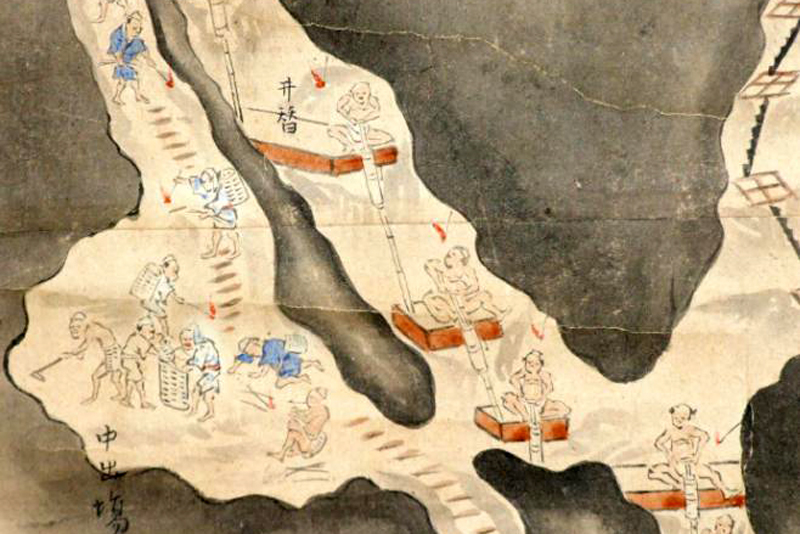
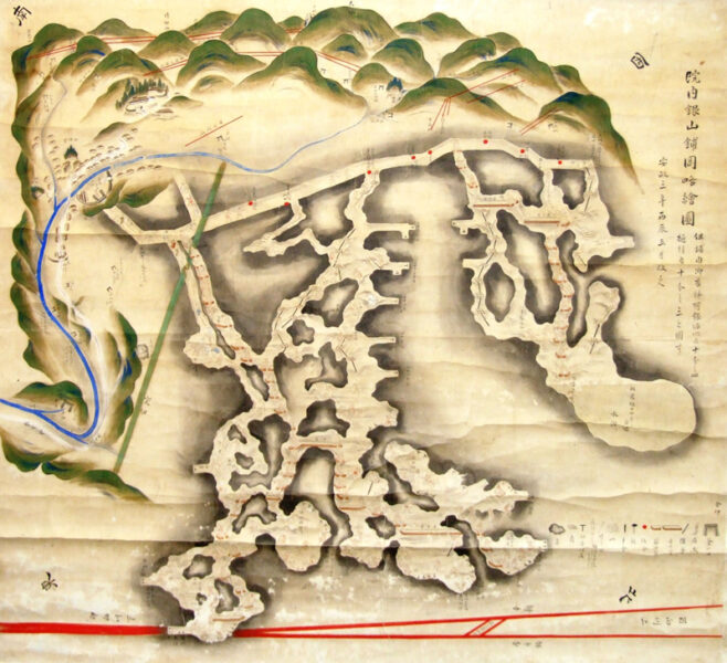
There are several drawings of the Edo period that give a good idea of its scale.
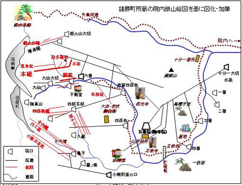
There are more than 20 known entrances, and the tunnels are constructed in a complex maze-like pattern. Mining has taken place 205 meters underground from the entrance called Daiichiyamashi
After the Meiji period, the mine came under direct government control. German engineers were quickly invited to the mine
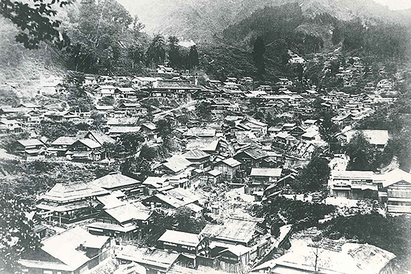
During the Meiji period, Innai Silver Mine was temporarily transferred from feudal domain management to private ownership, but from 1875 (Meiji 8) it became a mine directly under the control of the government
At that time, mining output had dropped significantly compared to its peak in the Edo period. To overcome this, mining engineers were invited from Germany, who introduced modern technology and dug tunnels 410 meters underground, successfully developing a new vein of ore. Between the 1880s and 1890s, annual production reached 10,000 to 14,000 kg
However, this did not last long, and the mine went into decline due to coal mine accidents and the transition from the silver standard to the gold standard. After the Taisho era, the mine was closed and reopened repeatedly, but finally closed completely in 1954 (Showa 29)
Materials relating to the Innai Silver Mine are on display. The building is modeled after the residence of a German engineer, the Innai Silver Mine Ijinkan
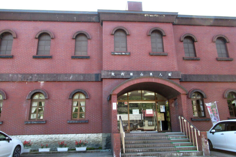
Innai Ginzan Ijinkan is a museum located next to JR Innai Station, which is the starting point for touring the former Innai Ginzan Silver Mine.
Inside the museum, you can see exhibits such as mining tools used at the Innai Silver Mine and a model of the bustling silver mining town. The brick-style building is a replica of a Western-style residence built for engineers invited from Germany in the early Meiji period
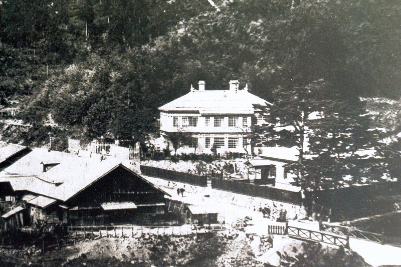
The original building that became the Innai Ginzan Ijinkan was located within the Innai Ginzan Silver Mine grounds and was built for five German engineers. This Western-style building was rare at the time, and local people an Ijinkan and treated it with special care. At the end of the Taisho period, when the silver mine was in decline, the building was sold to a private company, and then demolished due to deterioration, and now only the stone walls remain at the site.
Innai Ginzan Ijinkan <Information>
- Facility name: Innai Ginzan Ijinkan
- Address: 115 Ozawa, Kamiinai, Yuzawa City, Akita Prefecture
- Phone number: 0183-52-5143
- Opening hours: 9:00-16:30
- Admission fee: Adults 320 yen, Junior high school students and younger 210 yen
- Closed: Mondays (or the following day if Monday is a public holiday), New Year's holidays
- URL: Innai Ginzan Ijinkan
- access:
- Public transportation: Right next to Innai Station on the JR Ou Main Line
- By car: About 5 minutes from Ogachi Komachi IC on the Yuzawa Yokote Road
Google Map
Remains of Innai Silver Mine
Miyuki resistance
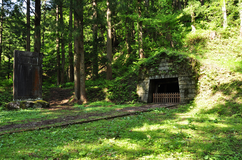
Miyuki Pit was formerly called Pit No. 5 and was the only entrance through which miners could enter and exit.
During the Edo period, an office (Yamagata Office) was located in the square in front of the mine entrance to monitor the miners. When Emperor Meiji inspected the Innai Silver Mine, he entered through this entrance, and the was later named "Mikoto."
In 1906 (Meiji 39), a mine fire occurred, killing over 100 people and said to have been a factor in the decline of the silver mine. The cause of the fire was a fire caused by careless bonfire, and the mine authorities closed the iron gate at the entrance to block out air, even though there were people inside the mine
early atrial anti
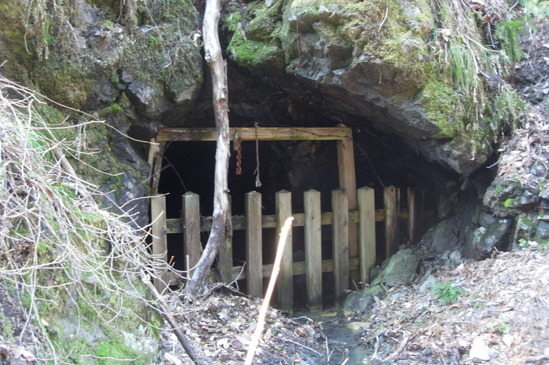
Hayabusako is a tunnel developed during the Kan'ei era (1624-1643) and is the oldest existing tunnel. It is a valuable tunnel that still conveys the excavation methods used in the Edo period to dig into extremely hard bedrock.
Kanayama Shrine
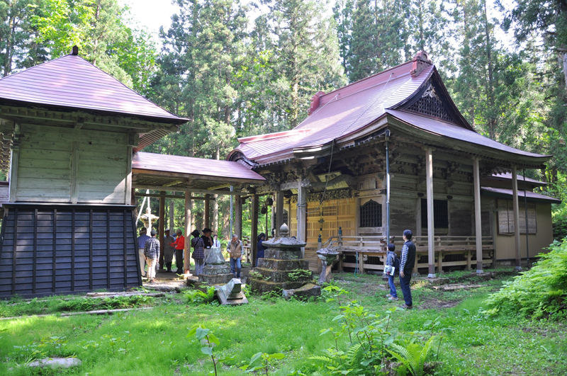
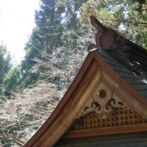
Kanayama Shrine has been the guardian shrine of the Innai Silver Mine since it was first discovered.
The shrine was highly protected by the Akita Domain, and successive feudal lords donated golden lanterns, calligraphy, paintings, and other items. The current shrine building was constructed in 1830. Every year on September 21st, "Mine Memorial Day," the Kanayama Shrine annual festival is held. It is a designated historic site of Akita Prefecture
Gozen water
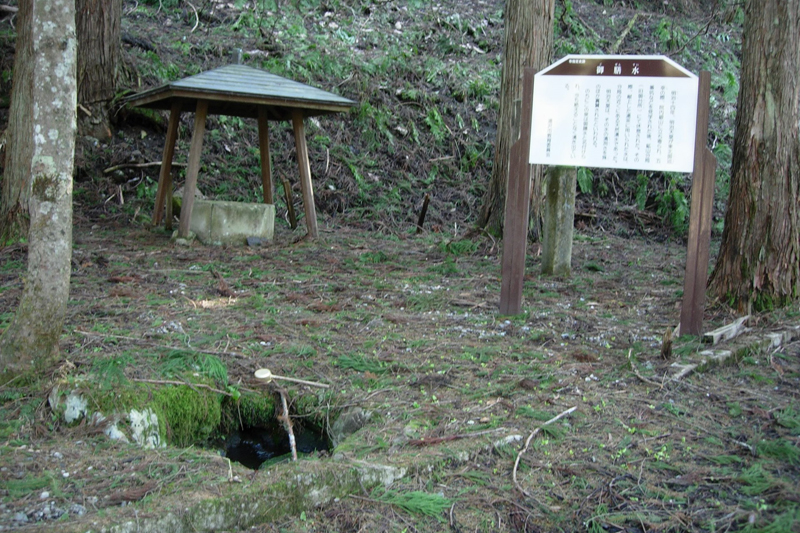
From the entrance to the Innai Silver Mine Historic Site (National Route 108), go southwest for 1.3 km to reach the front gate of Kanayama Shrine. From there, turn left and go up about 400 m upstream to find Gozensui
It is called "Gozensui" (Gozen Water) because it was used to present tea to Emperor Meiji when he inspected the Innai Silver Mine in 1881 (Meiji 14). Currently, it is surrounded by a cedar forest and cold, clear water springs out from it
Innai Silver Mine Historic Site <Information>
- Facility name: Innai Silver Mine Historic Site, Miyuki Pit, Hayafusa Pit, Kanayama Shrine, Gozensui
- Location: Innai Ginzancho, Shimoyucho and Kamihoncho, Yuzawa City, Akita Prefecture
- Phone number: 0183-55-8195 (Yuzawa City Tourism and Geopark Promotion Division)
- Free to visit
- access:
- Train: Approximately 13 minutes by car from JR Innai Station
- By car: Approximately 15 minutes from Ogachi Komachi IC on the Yuzawa Yokote Road
Google Map
The remains of Innai Guardhouse, which guarded the Innai Silver Mine and collected tolls
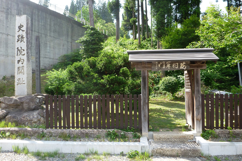
The Innai Bansho ruins are the site of a checkpoint (bansho) set up by the Akita Domain on the Ushu Kaido road, where they monitored ronin (masterless samurai) and guarded the Innai silver mine. They also levied a toll on people passing through the bansho, and it is said that they also collected about 10% of the ore trading price from the Innai silver mine and paid it to the domain.
Former Hospital Guardhouse <Information>
- Facility name: Innai Checkpoint/Innai Guard Station Ruins
- Location: Aramachi, Kamiinai, Yuzawa City, Akita Prefecture
- Phone number: 0183-55-8193 (Yuzawa City Lifelong Learning Division, Cultural Property Protection Office)
- Free to visit
- access:
- Train: Approximately 15 minutes on foot from JR Innai Station
- By car: Approximately 15 minutes from Ogachi Komachi IC on the Yuzawa Yokote Road
Google Map
Former Innai Elementary and Junior High School, a Meiji-era building
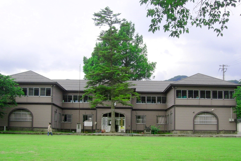
The former Innai Higher Elementary School (former Innai Elementary School building ) was founded in 1874 (Meiji 7), and the building that remains today was rebuilt in 1906 (Meiji 39). It was used as an elementary school throughout the Meiji, Taisho, and Showa periods, and closed in 1979 (Showa 54), but is now open to the public as the Innai Community Center.
Former Innai Elementary and Higher Elementary School <Information>
- Facility name: Former Innai Elementary and Secondary School
- Address: 60-1, Tayobashi, Uehara, Yuzawa City, Akita Prefecture
- Phone number: 0183-55-8193 (Yuzawa City Lifelong Learning Division, Cultural Property Protection Office)
- Cultural property: Yuzawa City designated cultural property
- access
- Train: Approximately 5 minutes on foot from JR Innai Station
- By car: Approximately 15 minutes from Ogachi Komachi IC on the Yuzawa Yokote Road
Google Map
The Kabayama Hydroelectric Power Station, built for the Innai Silver Mine, still generates electricity today
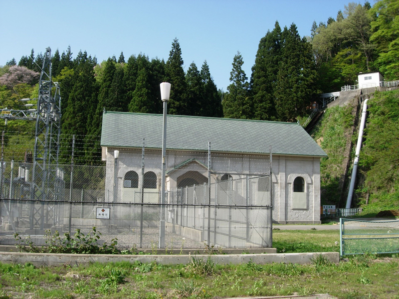
Kabayama Hydroelectric Power Station was built in 1900 (Meiji 33) to supply electricity to the Innai Silver Mine. The building is made of stone, and was constructed using stone quarried from the Innai Mine. The power station is still in operation today as the Tohoku Electric Power Kabayama Power Station, and although the building has been partially renovated, it is still in use as it was when it was first built. There are very few stone buildings in Akita Prefecture, making this a valuable building.
Kabayama Hydroelectric Power Station <Information>
- Facility name: Kabayama Hydroelectric Power Plant
- Address: 154 Akinomiya Kabayama, Yuzawa City, Akita Prefecture
- Phone number: Navi Dial 0570-550-220
- Owned by: Tohoku Electric Power
- access:
- Public transportation: Approximately 9 minutes by car from Innai Station on the JR Ou Main Line
- By car: Approximately 9 minutes from Ogachi Komachi IC on the Yuzawa Yokote Road via National Route 108
- URL: Kabayama Hydroelectric Power Plant


![[Akita Prefecture during the Boshin War] What decisions did the Kubota, Kameda, Honjo, and Yajima domains make? 24115050_m](https://jp.neft.asia/wp-content/uploads/2022/06/24115050_m-150x150.jpg)
![The Hiyama Ando clan, who ruled Akita during the Sengoku period and had their base in Noshiro [Akita Prefecture] Akita fan](https://jp.neft.asia/wp-content/uploads/2025/03/0275d341934f847be3452ea4662d9a4e-150x150.jpg)
!["Mogami Safflower" certified as a Japanese Heritage and Japanese Agricultural Heritage [Yamagata Prefecture] Mogami safflower](https://jp.neft.asia/wp-content/uploads/2022/12/30121446_m-1-150x150.jpg)
![[Akita Prefecture] Kosaka Town: A town that takes you back to the Meiji era. Cultural heritage left behind by the Kosaka Mine 1_22](https://jp.neft.asia/wp-content/uploads/2023/07/1_22-150x150.jpg)
![The castle town of Kubota Castle has been hit by numerous fires since the Meiji period and has changed dramatically since then [Akita City, Akita Prefecture] 25416843_m (1)](https://jp.neft.asia/wp-content/uploads/2024/01/25416843_m-1-150x150.jpg)
![The foundation of Akita City was the castle town of Kubota Castle, built by Satake Yoshinobu [Akita Prefecture] Yoshinobu Satake](https://jp.neft.asia/wp-content/uploads/2024/01/Satake_Yoshinobu-150x150.jpg)
