[The History of Hachirogata Reclamation ③] The land is below sea level… Water management is a lifeline [Ogata Village, Akita Prefecture]
table of contents
- 1 700 million tons of water from the reclaimed land surrounded by dikes is pumped out using large pumps
- 2 A floodgate was constructed in the Funakoshi Channel, which connects Lake Hachirogata with the open sea, blocking off the water from the sea
- 3 Foundation work for the drainage channel proceeded simultaneously with embankment construction
- 4 Ten months after the start of drainage, a dry-landing ceremony was held on the lakebed where the water had partially receded
- 5 Agricultural water intake using the siphon principle
- 6 The Western Channel is managed as an independent water body
- 7 The channel was designed to accommodate the difference in sea level between the eastern and western parts of the building
- 8 The farmland area of Ogata Village is comparable to the farmland area of Kanagawa Prefecture
- 9 Fishing has also been revived at Lake Hachiro
- 10 Learn about the past and present of Lake Hachirogata at the Ogata Village Reclamation Museum
On November 12, 1963, the 51.5km long levee was completed, and work finally began on draining the water
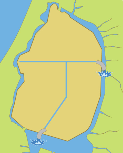
The Hachirogata reclamation project aims to use 16,000 hectares, or about 73% of the water surface of the former Hachirogata, which was about 22,000 hectares, as land.First, the former Hachirogata will be surrounded by a dike to create a large island.The water inside the dike will then be drained, and the exposed lakebed will be used for farmland and other purposes
700 million tons of water from the reclaimed land surrounded by dikes is pumped out using large pumps
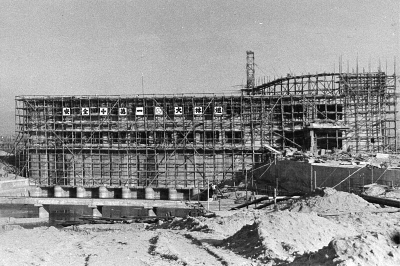
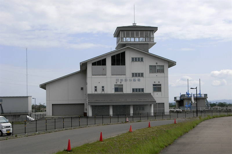
To drain the water, the Northern Pumping Station was established, which discharges the water into the Eastern Receiving Channel on the east side of the reclaimed land, and the Southern Pumping Station, which discharges the water into a regulating pond. The water was drained using multiple powerful drainage pumps, and calculations suggested that it would all be able to be drained in six months, but various safety considerations were taken into account, so it took two and a half years to complete. It is said that the amount of water drained was about 700 million tons
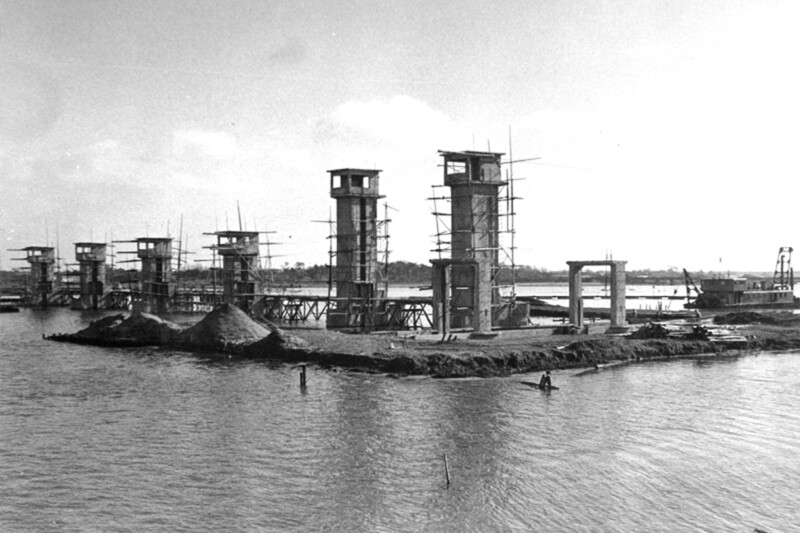
A floodgate was constructed in the Funakoshi Channel, which connects Lake Hachirogata with the open sea, blocking off the water from the sea
At the same time as the drainage work, work began on closing the opening that connected Lake Hachirogata to the open sea. Lake Hachirogata and the open sea were connected by a waterway called the Funakoshi Suido, which was about 4km long. By building a tide gate in this Suido, it would be possible to prevent seawater from flowing in and the water level from rising and falling due to the tides
Ten floodgates were built, one of which was designed to allow ships for reclamation work to pass through. In addition to the floodgates, there were also lock gates for fishing boats fishing in the open sea and regulating ponds, as well as fishways for fish. Lock gates are water gates that allow ships to pass through when the water levels at the entrance and exit are different, as in the famous Panama Canal, by adjusting the water levels using two locks
Furthermore, since the reclaimed land is farmland, saltwater cannot be used for agricultural purposes. Therefore, by stopping the inflow of seawater with the floodgates, Lake Hachiro, which is the water source, can be made into freshwater
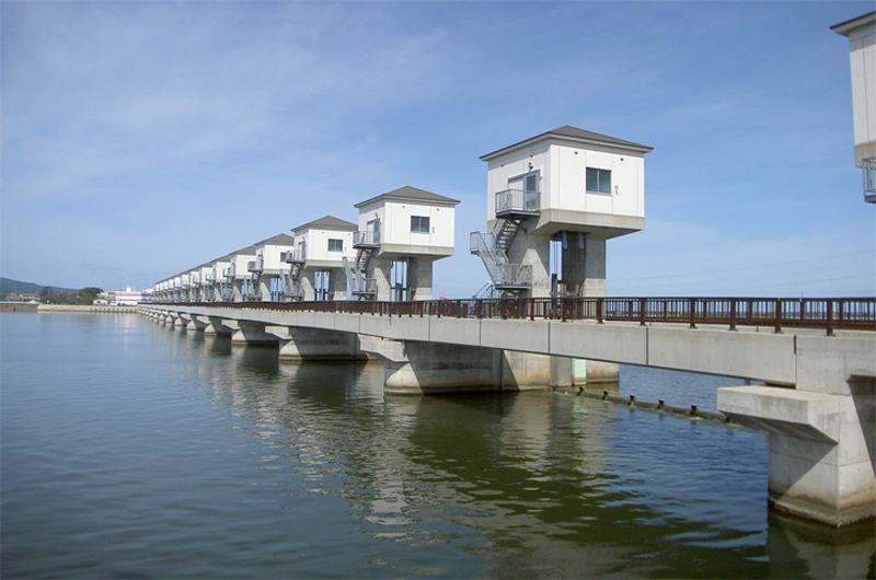
Since the beginning of the Heisei era, this flood gate has been renovated into a state-of-the-art facility, with the number of gates increased to 14, and it is still in use today
During the construction of the floodgate, the Funakoshi Channel, which had previously been meandering and had a low flow rate, was widened and straightened, and the riverbed was dredged (removing sludge from the riverbed to make it deeper)
Foundation work for the drainage channel proceeded simultaneously with embankment construction
In reclamation, even after the entire reclaimed land has been drained, excess water that accumulates within the land, such as rainwater, agricultural water, and domestic wastewater, needs to be discharged. Drainage is done from a drainage station, so a drainage channel needs to be built within the reclaimed land to reach the pumping station. Drainage channel construction has been carried out systematically since the embankment construction began
The sediment from the lake bottom was dredged for use in building the dike, and at the same time the location of the drainage channel was designed. The dredger used in the dike construction was used to dig the trench according to the design, completing the foundation work for the drainage channel. The dredged sediment is being used for the construction of the drainage channel's bank
Once the drainage was almost complete, full-scale construction of drainage channels began. A drainage network with a total length of 600 km was built within the reclaimed land, but because the lake bottom was originally made up of soft sludge, construction of the drainage channels was extremely difficult. This was overcome by developing new excavation machinery suited to the construction conditions, and a drainage network was created that still protects the reclaimed land today
Ten months after the start of drainage, a dry-landing ceremony was held on the lakebed where the water had partially receded
Drainage work began in November 1963 (Showa 38), and by September of the following year, 1964, 6,500 hectares of lakebed had emerged. This area was only about 35% of the reclaimed land, but it is said that 90% of the water had been drained. Although the area was not yet completely dry land, a grand government-sponsored drainage ceremony was held at this point. Ogata Village was also established that October
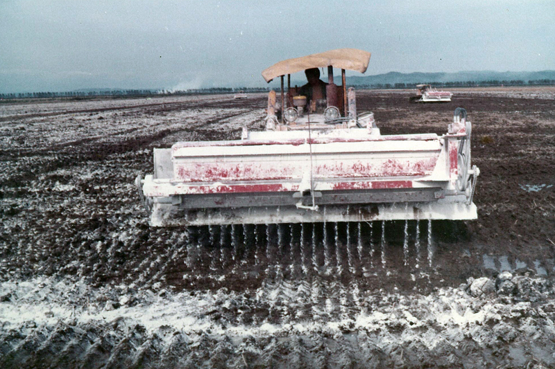
Because Hachirogata was a brackish lake, the reclaimed land contains salt. If left as is, it could become salt-damaged and cannot be used as farmland. What's more, the bottom of Hachirogata lake is sludge containing a lot of water. Sludge has the property of becoming highly acidic when it dries, so not many crops can grow there. It was necessary to improve the soil to a slightly acidic to neutral pH suitable for agriculture
The salt content is diluted by freshwater agricultural water and rain. Acidity caused by drying of the sludge was addressed by spreading alkaline lime
Agricultural water intake using the siphon principle
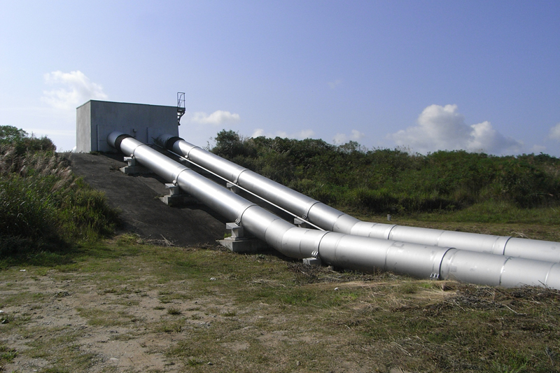
Hachirogata was reclaimed for agriculture, so after it was dried up, it was necessary to supply fresh water for agricultural use. The reclaimed land is surrounded by a freshwater regulating pond and two water channels, so it was planned to take water from there. For this reason, 19 water intake facilities have been set up on the dikes surrounding the reclaimed land
Because the levees of Lake Hachirogata were built on soft sludge, and although they have been reinforced, it was deemed a safety issue to run water intake pipes through the levees themselves, so intake pipes were installed across the levees in 12 locations on the eastern channel and regulating reservoir side. This method was extremely logical, as it maintained the strength of the levees while also allowing water to be pumped up without using power, using the siphon principle in reclaimed land where the water level is higher than ground level. The levees on the western channel side were built on good ground, so a method of running water intake pipes through the levees was adopted, and seven intakes were installed
The Western Channel is managed as an independent water body
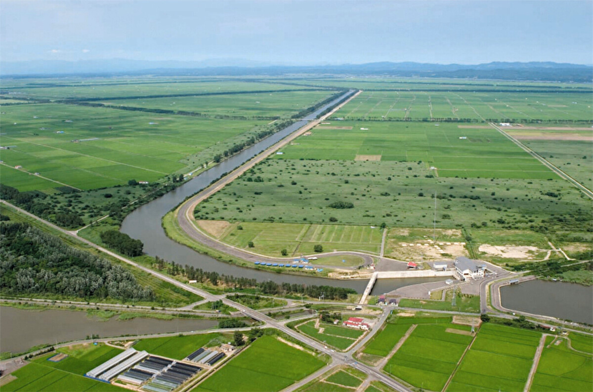
Lake Hachiro consists of a large regulating pond south of the reclaimed land, the Eastern Channel on the east side, and the Western Channel on the west side. Water can flow freely between the regulating pond and the Eastern Channel, but the Western Channel is separated from the Eastern Channel in the north by an embankment and is only connected to the Eastern Channel by a thin underground pipe. The southern part also has a thin channel connected to the regulating pond, but is a nearly independent body of water
This structure has been there since the time of reclamation, and was designed with a purpose. Lake Hachiro is a reservoir for drainage water from the reclaimed land, and also a source of agricultural water. The amount of agricultural water needed to cover the vast reclaimed land is enormous, and without a source of fresh water, the lake would quickly dry up. Fortunately, there are nearly 20 rivers that flow into Lake Hachiro, which annually accounts for half the amount of water flowing into the lake. However, these rivers are concentrated on the east bank, and there is not a single one on the west bank
The channel was designed to accommodate the difference in sea level between the eastern and western parts of the building

Lake Hachiro is adjusted so that the inside of the floodgates is kept at 35cm above sea level (altitude). Basically, any river water above 35cm is released through the floodgates via the Funakoshi Channel, which connects to the open sea. However, during busy farming seasons when large amounts of water are needed, water must be stored in Lake Hachiro. For this reason, it was decided to raise the water level to 1m above sea level and supply a fixed amount of water to the reclaimed land every day
However, if the water level is raised to 1 meter above sea level, safety issues will arise unless a levee is built not only on the reclaimed land side, but also on the opposite bank where no levee exists. However, building a levee on the opposite bank would require a levee that is approximately 82 km long, the entire circumference of Lake Hachirogata. This would require enormous amounts of materials, labor, time, and cost
The only rivers that flow into Lake Hachiro are on the east bank, not the west bank. Therefore, if we prevent other water from flowing into the Western Channel, the water level in the Western Channel will hardly increase naturally, and we will only need to add water when necessary. Since the water that is added is immediately used for agricultural purposes, the water level will remain low above sea level, and there will be no need for a levee on the opposite bank. Because building a levee would be expensive, the Western Channel was deliberately built as an independent channel
There are currently four pumping stations for drainage etc. The balancing reservoir has four drainage pumps and the Southern Drainage Pumping Station has one for regulating the Western Receiving Channel, the Northern Drainage Pumping Station has four drainage pumps for the Eastern Receiving Channel, and the Kataguchi Drainage Pumping Station has three. The Western Receiving Channel is also served by the Hamaguchi Pumping Station (two pumps) which operates to regulate the water level
The farmland area of Ogata Village is comparable to the farmland area of Kanagawa Prefecture
The Hachirogata reclamation project began in 1957 and took about 20 years to complete, completing in 1977. The farmland in Ogata Village that was made up of the reclaimed land now boasts an area comparable to the rice paddies in the entire Kanagawa Prefecture
- Ogata Village New Rural Construction Project (Hachirogata New Rural Construction Project Association)
- Farmland development: 11,202ha
- Village land development: 687 ha of residential land development
- Disaster prevention forest 492ha
- Road within the residential area 19.3km
- Public facilities: town halls, community centers, clinics, kindergartens, elementary schools, junior high schools, water supply systems, sewerage systems, garbage disposal plants, cemeteries, streets, etc
- Agricultural facilities: 580 farmhouses, 6 country elevators, 2 dry stores, 104 machinery hangars
- Other: Training prospective settlers, farming guidance for settlers, purchase and transfer of farming machinery, etc
- Source: Agriculture and Rural Development Information Center "Foundation of Water and Soil"
Fishing has also been revived at Lake Hachiro
The reclamation of Lake Hachirogata left behind a lake that was about 20% of the size of the old Lake Hachirogata. The remaining lake (Lake Hachirogata) changed from brackish water mixed with seawater to fresh water, but fishing activities were partially revived after the reclamation project was completed. The catch has decreased from around 1,900 tons before the reclamation to around 250 tons, but around 170 people still continue to fish, mainly by fishing for smelt
Learn about the past and present of Lake Hachirogata at the Ogata Village Reclamation Museum
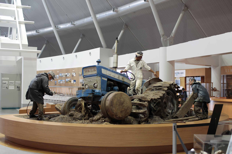
This museum was established to preserve for future generations the traces of the historic project to reclaim Hachirogata Lagoon, the second largest lake in Japan. Materials on the history and significance of the Hachirogata Lagoon reclamation, the existence of Ogata Village, and reclamation techniques are collected and displayed through videos and panels
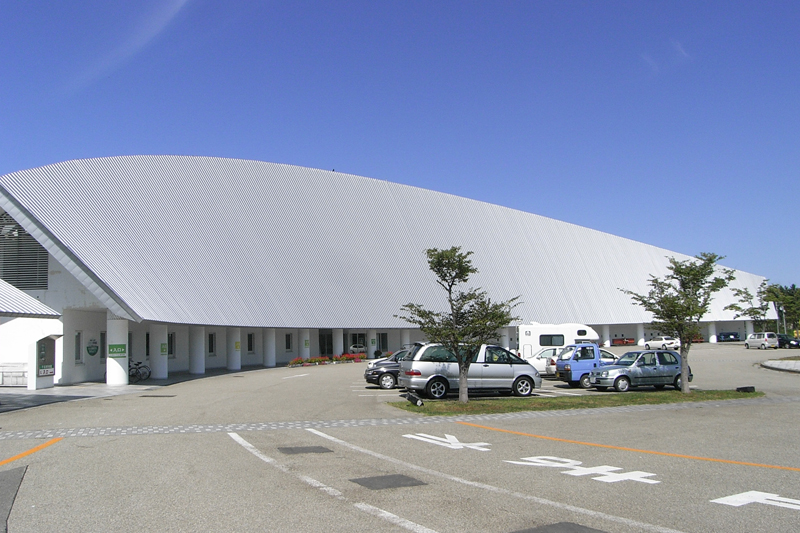
Ogata Village Reclamation Museum <Information>
- Facility name: Ogata Village Reclamation Museum
- Address: Nishi 5-2, Ogata Village, Minamiakita District, Akita Prefecture
- Phone number: 0185-22-4113
- Opening hours: 9:00-16:30 (entry until 16:00)
- Closed days
- April to September: 2nd and 4th Tuesdays
- October to March: Tuesdays, New Year's holidays (December 31st to January 3rd)
- *If Tuesday is a public holiday, the museum will be closed the following day
- Admission fee: Adults and university students 300 yen, elementary, junior high and high school students 100 yen,
- * Free admission for customers with disability certificates or rehabilitation certificates, including their accompanying persons
- URL: Ogata Village Reclamation Museum
- access
- Public transportation: Approximately 20 minutes by taxi from Hachirogata Station on the JR Ou Main Line
- By car: Approximately 15 minutes from Kotooka Moritake IC on the Akita Expressway
Google Map
Ogata Village <Information>
Ogata Village
- Location: Ogata Village, Minamiakita District, Akita City
- Phone number: 0185-45-2111
reference
- Ogata Village Encyclopedia
- Oga Peninsula/Ogata Village Geopark
- Beautiful Country Akita Net
- Agriculture and Rural Development Information Center "Foundation of Water and Soil"



![[The History of Hachirogata Reclamation ①] Japan's second largest lake became a vast rice field [Ogata Village, Akita Prefecture] 7561d23df2a0ec24c664e184c3fc8d8f](https://jp.neft.asia/wp-content/uploads/2024/07/7561d23df2a0ec24c664e184c3fc8d8f-150x150.jpg)
![[Iwate Prefecture] Sake, miso, and wasabi flavored soft serve ice cream! Why is the soft serve ice cream at roadside stations so delicious? They even serve lunches! Central Iwate Prefecture Catch](https://jp.neft.asia/wp-content/uploads/2025/06/915fd0ce722ab0f21e74864401170847-150x150.jpg)
![[Yamagata Prefecture] Let's go try the delicious, locally produced soft serve ice cream at Yamagata's roadside station! Yamagata Catch](https://jp.neft.asia/wp-content/uploads/2025/07/2c2e7024e6ed08990103582514a5844e-150x150.jpg)
![[Iwate Prefecture] Unique soft serve ice cream near Morioka City! Why is the soft serve ice cream at roadside stations so delicious? Morioka 4](https://jp.neft.asia/wp-content/uploads/2025/05/189a4a932dca375175b5cc49cd9a6d53-150x150.jpg)
![[Akita Prefecture] Akita has more than just Babahera ice cream! 5 roadside station soft serve ice creams with a wide variety! Showa 7](https://jp.neft.asia/wp-content/uploads/2025/07/635663812d6465cd23ff69f727cb14a8-150x150.jpg)
![[Iwate Prefecture] Japanese-style soft serve ice cream from the southern Sanriku coast! Why is the soft serve ice cream at roadside stations so delicious? IMG_0050](https://jp.neft.asia/wp-content/uploads/2025/06/IMG_0050-150x150.jpg)

![[Akita Prefecture] Part 2 of Akita Roadside Station Soft Cream! 4 Popular Soft Creams in the Prefecture's Inland Rice-Growing Region! Akita 2 Catch](https://jp.neft.asia/wp-content/uploads/2025/08/bf9fa170ebe4e828628e72952707b851-1-150x150.jpg)
