This site is an online media that delivers all sorts of trivia about the six Tohoku prefectures, from sightseeing and gourmet spots to local customs, history, and more
There is an irrigation canal that runs from Lake Inawashiro to Koriyama City. This canal is built by digging a tunnel through the mountains between Lake Inawashiro and Koriyama City to supply water to Koriyama City
"Asaka Sosui,"was built during the Meiji era and still irrigates the Koriyama area today, and is also used for hydroelectric power generation.
The historical story of the Asaka Canal has been recognized as a Japan Heritage Site by the Agency for Cultural Affairs as "A Single Waterway that Opened Up the Future - Okubo Toshimichi's 'Final Dream' and the Path of Pioneers in Koriyama and Inawashiro." It has also been registered as a World Heritage Site for Irrigation Structures by the International Commission on Irrigation and Drainage (ICID)
The Asaka Plain Reclamation Project, which began in the early Meiji period
Koriyama has been called Asaka-gun since the Heian period, and was the territory of the Nihonmatsu domain during the Edo period. It was a post town on the Oshu Kaido road, and seems to have been quite a bustling town. However, Asaka-gun, which includes Koriyama-juku, was covered with desolate wilderness due to the dry winds blowing down from the Oshu Mountains, which dried out the land, and there were few water sources
The project to cultivate the Asaka Plains began in 1873 (Meiji 6) by local people. A group of pioneers formed a private reclamation company called Kaisei-sha, and began cultivating the land using innovative methods such as planting imported fruit trees and using Western farming tools. The Kaiseikan development office, a Western-style building, was built by local carpenters, imitating examples from woodblock prints and other art
However, there is still not enough water to turn this wilderness into fertile land. So, the local people, including Kaiseisha, wanted to draw water from the large Lake Inawashiro, which is located to the west of the mountain. This was a long-cherished wish of the local people
The Meiji government realized its long-cherished wish to draw water from Lake Inawashiro
Overview of the Asaka Canal from the Meiji period. Collection: Koriyama City Library
As the Edo period turned to the Meiji era, many of the feudal lords in various regions lost their jobs. This problem troubled the Minister of the Interior, Okubo Toshimichi, who thought that he could help these unemployed samurai by carrying out a large-scale land improvement project to channel water from Lake Inawashiro to Asaka, and in 1878 (Meiji 11), he was the first in the country to allocate a budget for the "Asaka Reclamation and Asaka Canal Construction Project."
However, just before the Asaka reclamation project was to begin, Okubo Toshimichi, who had been leading the effort, was assassinated (May 14, 1878, the Kioizaka Incident)
Minister of Home Affairs Okubo Toshimichi (Okubo Toshimichi) Collection: National Diet Library
The Asaka Reclamation and Asaka Canal Construction Project, which carried on the will of Toshimichi Okubo
Although Okubo Toshimichi passed away tragically before he could even see the start of the project, the project itself was put into action
The first group arrived on November 11, 1878 (Meiji 11) from the former Kurume Domain, followed by over 2,000 former samurai and their families from nine domains across the country, including the former Okayama Domain, the former Tosa Domain, the former Tottori Domain, and the former Nihonmatsu Domain
The grand plan, "Asaka Reclamation and Asaka Canal Construction Project," which involved digging a tunnel through the mountain (Ou Mountains) towering between Lake Inawashiro and the Asaka Plains, and directing water through it, was launched in October 1879 (Meiji 12) as a project directly managed by the national government
The groundbreaking "Jurokubashi Water Gate" designed by Dutch engineer Van Doorn
The first project was the construction of a floodgate on the west side of Lake Inawashiro, which would regulate the flow of water towards Aizu
By discharging the water from Lake Inawashiro towards the Asaka Plains, it was not possible to reduce the flow of water to the Aizu area, which had been using the lake water until then. To solve this problem, a Dutch engineer, Van Doorn, who was a Meiji government engineer, came up with a scientific method that had not been used in Japan until then
The idea was to build a dam-like weir where the lake water flows out towards Aizu, and to allow a stable, constant amount of water to flow out through a sluice gate.The huge sluice gate, called the "Jurokukyo Sluice Gate," was completed in 1880 (Meiji 13)
The Jurokubashi Water Gate is made of stone and has 16 stone gates over which an arched bridge can be crossed. It was later renovated to its current form in 1914 (Taisho 3) for the development of power sources. The Jurokubashi Water Gate has been designated as a Heritage of Industrial Modernization
Jurokubashi Water Gate<Information>
Name: Jurokubashi Water Gate
Address: Ozawa-oaza Senba, Inawashiro-machi, Yama-gun, Fukushima Prefecture and Akaidonokuchi, Minato-machi, Aizu-Wakamatsu City
Phone number: 024-922-4595 (Asaka Canal Land Improvement District)
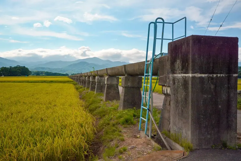
The Asaka Canal, which was completed in three years, includes the Numagami Tunnel and waterways that run through the Ou Mountains
At roughly the same time as construction of the Jyurokubashi Water Gate, construction of the intake and tunnel into the Asaka Plains began
The intake was originally built in Yamagata (Yamagata, Inawashiro Town). Water from Lake Inawashiro flows through a tunnel into the valley on the other side
This tunnel, called the Numakami Tunnel, passes through Mount Numakami (761m above sea level) and is 585m long.Construction began in December 1879 (Meiji 12) and was completed in July 1881 (Meiji 14)
This allowed the water from Lake Inawashiro to flow through the Ou Mountains and into the Asaka Plains for the first time. The intake was later moved to Joto Headworks (Yamagata, Inawashiro Town), a little north of the Yamagata Water Gate, and is still in operation today
After passing through the Numagami Tunnel, the water from Lake Inawashiro flows down like a waterfall from the exit on the Koriyama side, joins the Gohyaku River, and flows downstream
The Asaka Canal, which flowed into the Asaka Plains, was diverted into approximately 52.1 km of canal channels and approximately 78 km of diversion channels, irrigating approximately 3,000 hectares of new farmland. The Asaka Canal was completed over a three-year construction period, with a total of 850,000 workers and a national budget of 407,000 yen (approximately 40 billion yen today)
The Asaka Canal has since undergone renovations and expansion, and now supplies water to approximately 10,000 hectares of rice paddies
The Asaka Canal, which is also used for hydroelectric power generation
The Asaka Canal flows like a waterfall into the Gohyaku River where it joins. Hydroelectric power plants were built using this flow. The first one completed was the Numakami Power Plant in 1899 (Meiji 32), which uses the difference in height where water flows from the Numakami Tunnel into the Gohyaku River to generate electricity
After that, "Takenouchi Power Station" was put into operation in 1919 (Taisho 8), and "Marumori Power Station" was put into operation in 1921 (Taisho 10). "Numakami Power Station", "Takenouchi Power Station" and "Marumori Power Station" have been designated as Heritage Sites of Industrial Modernization
Heritage of Industrial Modernization Power Plant <Information>
Name: Numagami Power Plant
Address: Ankojima, Atami-cho, Koriyama City, Fukushima Prefecture
Phone number: 0242-22-4611 (TEPCO Renewable Power Inawashiro Office)
Google Map
Name: Takenouchi Power Plant
Address: Takenouchi, Yasukoshima, Atami-cho, Koriyama City, Fukushima Prefecture
Phone number: 0242-22-4611 (TEPCO Renewable Power Inawashiro Office)
Google Map
Name: Marumori Power Plant
Address: Atami 5-chome, Koriyama City, Fukushima Prefecture
Phone number: 0242-22-4611 (TEPCO Renewable Power Inawashiro Office)
Google Map
Many historical sites and related facilities of the Asaka Canal remain in Koriyama City
There are many historical sites and facilities related to the Asaka Canal in Koriyama City, where you can learn about its history
The birthplace of Asaka reclamation, home to Kaiseikan, government housing, and settler homes
Kaiseikan was used as a base for development, and later as the county office and Kuwano village (now Koriyama city) office, and is now a museum that conveys the history of Asaka development and the Asaka Canal. Kaiseikan is an Important Cultural Property of Fukushima Prefecture and a Heritage of Industrial Modernization certified by the Ministry of Economy, Trade and Industry
Within the grounds of Kaiseikan (a historic site in Koriyama City known as the birthplace of the Asaka reclamation), there are the Asaka Reclamation Official Residence (former Tateiwa Ichiro residence; restored and designated an important cultural property by Koriyama City), the Asaka Reclamation Settlers' Residence (former Koyama residence; relocated and restored and designated an important cultural property by Koriyama City), and (former Tsubouchi residence; relocated and restored), which are open to the public (all temporarily closed in 2022)
The birthplace of Asaka reclamation <Information>
Name: Birthplace of Asaka Development
Address: 3-3-7 Kaisei, Koriyama City, Fukushima Prefecture
Hayama Park was built in 1827 to commemorate the promotion of Koriyama Village to a post town by the Edo Shogunate. In the Meiji era, after the Asaka Canal was completed, the Asaka Canal's Hayama Falls, where the canal flows like a waterfall, was built to commemorate the occasion. The Asaka Canal's Hayama Falls is a registered tangible cultural property of Japan
Rokuyama Park<Information>
Name: Rokuyama Park
Address: 1-chome, Fumotoyama, Koriyama City, Fukushima Prefecture
Phone number: 024-924-2194 (Koriyama City Tourism Promotion Corporation 21st Century Memorial Park Office)
Google Map
The former Fukushima Prefectural Junior High School main building, where people involved with the Asaka Canal also attended
The school building of Fukushima Prefectural Junior High School, which opened in 1889 (Meiji 22), has been left as it is and is open to the public as the Asaka History Museum. Many people involved in the Asaka Canal attended this school. The main building of the former Fukushima Prefectural Junior High School is a nationally designated important cultural property
Asaka History Museum <Information>
Name: Asaka History Museum (former Fukushima Prefectural Junior High School main building)
Address: 5-25-63 Kaisei, Koriyama City, Fukushima Prefecture
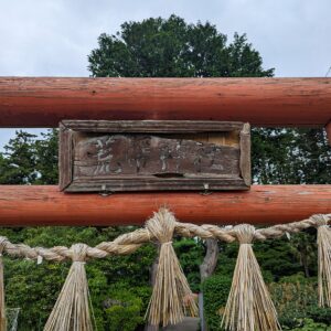
Asaka Canal Shrine is a shrine worshipped as the guardian deity of the Asaka Canal. It is said that workers heading to the canal construction site always prayed there before heading out
Asakasosui Shrine <Information>
Name: Asakasosui Shrine
Address: Ankojima, Atami-cho, Koriyama City, Fukushima Prefecture
This shrine was built in memory of Okubo Toshimichi, who devoted himself to the construction of the Asaka Canal, but was assassinated before it could be completed. It was founded in 1889 (Meiji 22), and there is no main building, only a memorial monument
Okubo Shrine <Information>
Name: Okubo Shrine
Address: 4-112 Ushina, Asaka-cho, Koriyama-shi, Fukushima Prefecture (within the grounds of the Ushina Branch of Asaka Community Center)
My love of travel led me to work for a travel magazine some time ago, and now I work as a travel writer for an online publication. I have visited all 47 prefectures in Japan, focusing on the Tohoku region, and I enjoy soaking in hot springs and experiencing traditional Japanese culture, including old townscapes, lifestyles, and performing arts and crafts


![What day is it today? Tohoku Edition [1001]](https://jp.neft.asia/wp-content/uploads/2026/03/1001-150x150.png.webp "[What day is it today? | Tohoku Edition] What day is October 1st?")