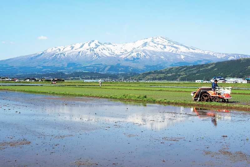
[Mount Chokai-Tobishima Geopark: Yuza and Sakata] The Shonai Plain is blessed with the bounty of Mount Chokai
table of contents
- 1 Mount Chokai was formed into its current shape by a major eruption during the Edo period
- 2 The Shonai Plain Eastern Edge Fault Zone stretches in a straight line for 35 km
- 3 The abundant waters of Mt. Chokai that nourish the Shonai Plain
- 4 "Miko no Mizu" - a blessing from the sacred mountain that is essential to life
- 5 Ushiwatari River and Maruike Pond, formed by spring water
- 6 Chokaisan Omonokimi Shrine, which enshrines the sacred mountain of Mt. Chokai
- 7 Sixteen Rakan Rocks carved into lava as a memorial for those who died in a maritime accident
- 8 Articles related to Mt. Chokai and Tobishima Geopark
Mount Chokai is a rare mountain with two peaks (East Chokai-san Shinzan and West Chokai-san Nabemori) that rise from 0m above sea level on the Sea of Japan all the way to the summit at 2,236m.Due to its beautiful appearance, it has been nicknamed "Dewa Fuji."
It is an active volcano, and the people living at its foot, such as Yuza, Sakata, Kisakata (Nikaho City, Akita Prefecture), and Yuri (Yurihonjo City, Akita Prefecture), fear Mount Chokai, which sometimes spews fire as if in anger and shakes the earth, but they also worship it as a mountain where gods dwell, and as a source of abundant water
Mount Chokai was formed into its current shape by a major eruption during the Edo period
Mt. Chokai began to become active around 550,000 years ago, and lava is believed to have covered the surface of Nishi-Chokai (Nabemori Lava Dome, 1,652m above sea level) around 160,000 to 20,000 years ago.
From about 20,000 years ago onwards, Mt. Higashi-Chokai, located in the eastern part of the mountain, was formed. About 2,600 years ago, the summit of Mt. Higashi-Chokai collapsed, and the resulting lava formed a crater floor (caldera), and the resulting deposits created the topography of the foothills
Of the two central cones of Mount Higashi-Chokai, Mount Shinzan (2,236m) is a lava dome formed in an eruption in 1801 (the first year of the Kyowa era), and is also known as Mount Kyowa
Mount Chokai erupted frequently until the late Heian period (900s). After that, there were no records of eruptions until the mid-1600s, but activity began to resume around 1659. Then, in 1801, a major eruption occurred that remains in historical records
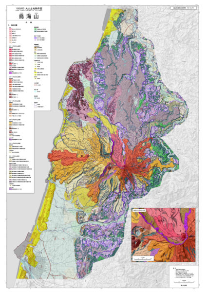
Traces of the great eruption remain on the mountain and in the Shonai Plain
Phreatic eruptions that began in 1800 gradually became more intense, and in late August 1801 a major explosion occurred, killing eight climbers. In 1804 (the first year of the Bunka era), a major earthquake (Kisakata earthquake) occurred, causing extensive damage to the foothills of the mountain
There have been no large-scale eruptions since then. The most recent eruption was a small phreatic eruption near Shinzan in 1974 (Showa 49), which resulted in mudflows and ash fall. A swarm of earthquakes also occurred in 1987 (Showa 62)
The active volcano Mt. Chokai has changed the shape of the earth with each eruption and earthquake, attacking people. Traces of this change remain to this day as faults and lava flows, a topography unique to the Shonai region. This unique topography has been certified as , the Mt. Chokai-Tobishima Geopark
Mt. Chokai-Tobishima Geopark <Information>
- Phone number: 0184-62-9777 (Mount Chokai-Tobishima Geopark Promotion Council Secretariat)
- URL: Mt. Chokai-Tobishima Geopark
Lava dome Shinzan, the site of a violent explosion
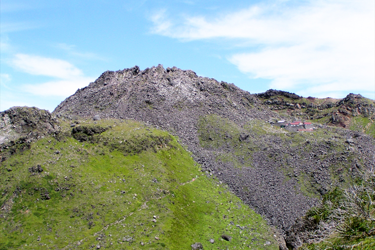
Shinzan is a lava dome formed during a major explosion at Higashi-Chokai in 1801, and stands 70m above the crater floor.
It is possible to climb up to Shinzan, and it takes about 5 hours and 30 minutes from the Ohira entrance (Yuza Town, Yamagata Prefecture) or the Hokodate entrance (Nikaho City, Akita Prefecture) of the hiking trail, or about 20 minutes from Omuro Hut (Omuro Sanrojo/accommodation facility) next to the main shrine at the summit of Chokaisan Omonoimi Shrine
A large rock near the main shrine at the summit weighs 300 tons and is a volcanic bomb that was dropped when the new mountain was born. It tells us how violent the eruption was
Lake Chokai, a crater lake filled with meltwater
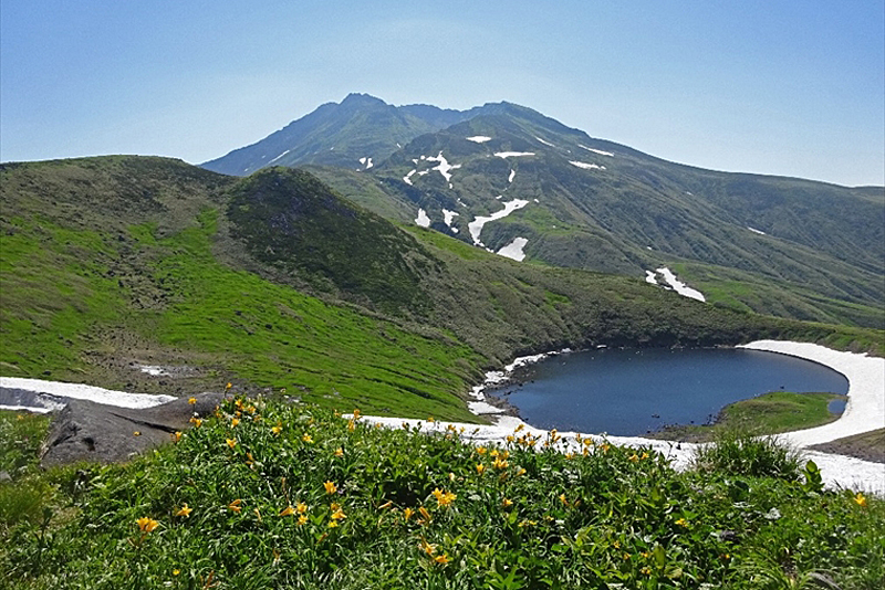
Lake Chokai (also known as Tori no Umi or Torinoumi) is a crater lake located about 3km west of Shinzan (East Chokai) and at an altitude of about 1,600m on West Chokai
It has a diameter of about 200m and is oval-shaped, elongated from north to south. The water comes from melted snow, and in the harsh winter it is a rare lake where the lake freezes all the way down to its bottom, which is 4.7m deep. Nearby is Tori-no-umi Mihama Shrine, and the Mihamagoya (Mihama Sanrosho) accommodation facility
Normal faults running down the mountainside of Mt. Chokai
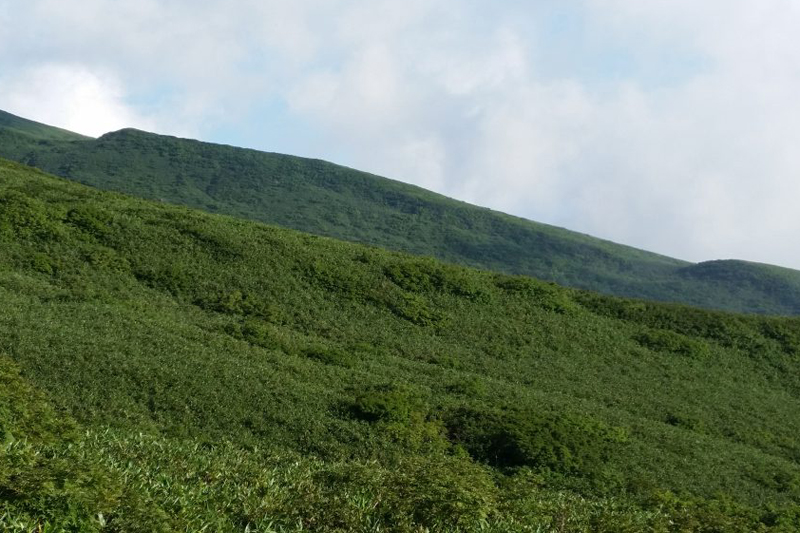
The slopes of Mt. Chokai are home to a group of active faults typical of volcanoes. Many of these faults are found from the horseshoe-shaped caldera of Nishi-Chokai to the middle of the western slope, and in the area called Gassan-Mori (1,650m)
The active fault on Mt. Chokai is a normal fault, which is common in Kyushu, but rare in northern Japan. The one on the western slope of the mountain is called the Sarazawa Fault, and has a cliff with a maximum drop of about 30m that stretches for 2.5km. The Gassan-Mori Fault has a maximum drop of about 50m and is 1.5km long.
The Shonai Plain Eastern Edge Fault Zone stretches in a straight line for 35 km
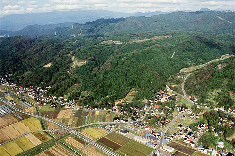
An active fault line runs along the edge of the Shonai Plain. the Shonai Plain Eastern Edge Fault Zone and stretches from Yuza Town at the foot of Mt. Chokai to Sakata City, Shonai Town, and Tsuruoka City, about 35 km south.
As of 2022, the probability of an earthquake occurring within the next 100 years on the Shonai Plain Eastern Edge Fault Zone is 0% in the north and less than 20% in the south (Announced on October 19, 2009 by the Earthquake Headquarters, Earthquake and Disaster Prevention Research Division, Research and Development Bureau, Ministry of Education, Culture, Sports, Science and Technology). However, it is said to have caused the Shonai earthquake of 1894 (Meiji 27) in the past, so it is still an active fault and requires careful vigilance
The abundant waters of Mt. Chokai that nourish the Shonai Plain
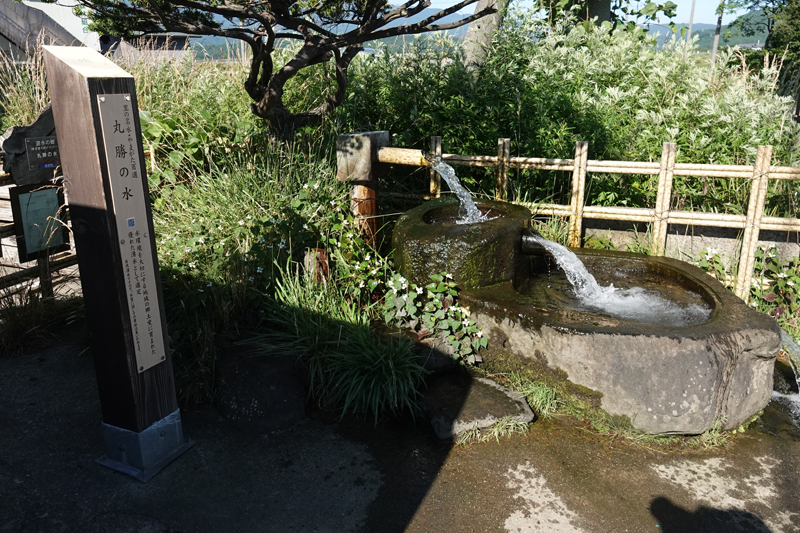
The Motomachi district in the center of Yuza Town is located on an alluvial fan of the Gekko River, which originates from Mt. Chokai, and is extremely rich in groundwater. As a result, water gushes out when a well is dug, with about 300 wells in total, and the amount of water that gushes out is 4,200 tons per day
The Yuza Motomachi Spring Water Park (Machi Meguri Park) a walking course along the Gekko River from Yuza Station , offers free access to 14 artesian wells, courtesy of their owners. However, although testing is OK, the water is not sterilized, so drinking is at your own risk.
Yusa Motomachi Springs <Information>
- Facility name: Yuza Motomachi Springs (Machi Meguri Park)
- Location: Yuza Town, Yamagata Prefecture, near JR Yuza Station
- Phone number: 0234-72-5666 (Yusa Chokai Tourism Association)
- URL: Machimeguri Park
"Miko no Mizu" - a blessing from the sacred mountain that is essential to life
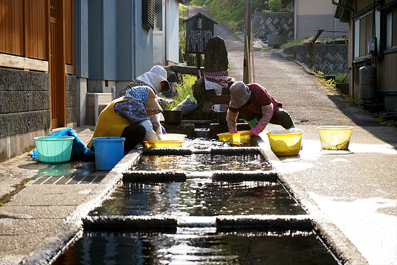
Mizu is a washing place that uses spring water in the Mega village in Yuza town.
Mega is a coastal village where the foot of the sacred mountain, Mt. Chokai, sinks into the Sea of Japan, and the spring water is named "Shinsen no Mizu" (Water of the Divine Spring) because it is drawn from the sacred mountain. The spring water is divided into six tanks and separated according to its use
Miko no Mizu <Information>
- Facility name: Miko no Mizu
- Address: 64 Mega, Fukiura, Yuza-machi, Akumi-gun, Yamagata Prefecture
- Phone number: 0184-62-9777 (Mount Chokai-Tobishima Geopark Promotion Council Secretariat)
- access
- By car: Take the Yamagata Expressway to Sakata Minato IC and head towards Akita on National Route 7 for approximately 25 minutes
- Train: About a 5-minute walk from Mega Station on the JR Uetsu Main Line
- Toilets: None
- Parking: None
- URL: Miko no Mizu
Google Map
Ushiwatari River and Maruike Pond, formed by spring water
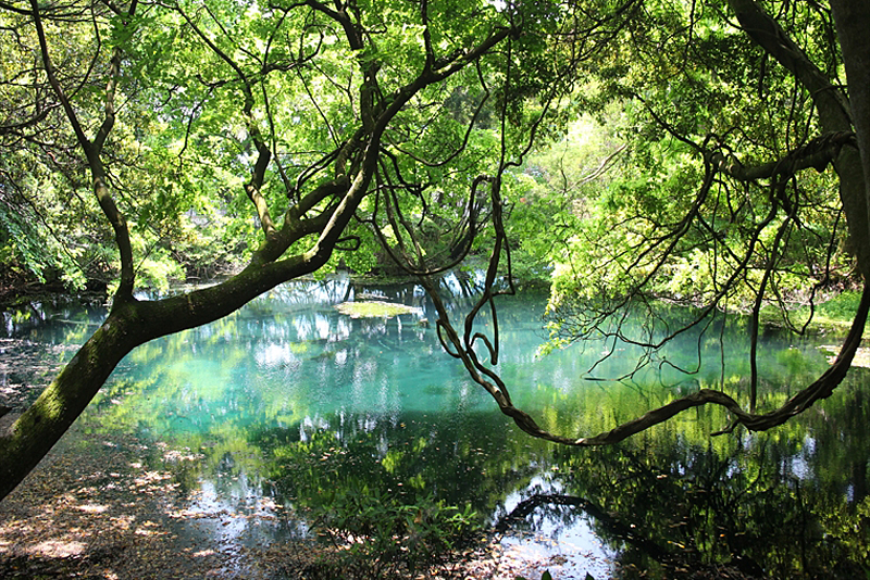
Ushiwatari River is a short river about 4km long at the foot of Mount Chokai on the Sea of Japan side, and almost 100% of its flow is spring water. The water temperature is around 11°C throughout the year, and in autumn salmon swim upstream.
Maruike-sama is a spring-fed pond located near the Ushiwatari River, approximately 20 meters in diameter and 3.5 meters deep. It is one of the sources of the Ushiwatari River, and on its banks stands Maruike Shrine, which enshrines Maruike-sama as its sacred object
Ushiwatari River and Maruike Pond <Information>
- Facility name: Ushiwatari River and Maruike Pond
- Phone number: 0234-72-5666 (Yusa Chokai Tourism Association)
- access
- By car: Take the Yamagata Expressway to Sakata Minato IC and head towards Akita on National Route 7 for approximately 25 minutes
- Train: Approximately 5 minutes by car from Fukiura Station on the JR Uetsu Main Line
- Toilets: Available (temporary)
- Parking: Available (free)
Google Map
Chokaisan Omonokimi Shrine, which enshrines the sacred mountain of Mt. Chokai
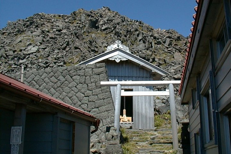
Chokaisan Omonokimi Shrine is a shrine where prayers were offered to appease the anger of Mount Chokai, and is said to have been founded in 564 (the 25th year of the reign of the 29th Emperor Kinmei) during the late Kofun period. The main shrine, the summit main hall of Chokaisan Omonokimi Shrine, is enshrined at the summit of Mount Chokai near Niiyama, and at the foot of the mountain there are two village shrines called "Kuchinomiya" in Fukiura (Fukuura / Mount Chokai Omonokimi Shrine Fukiuraguchinomiya) and Warabioka (Warabioka / Mount Chokai Omonokimi Shrine Warabiokaguchinomiya).
During the late Heian period, it was ranked as the Ichinomiya of Dewa Province and is the highest ranking shrine in the country. The main hall on the summit is rebuilt every 20 years, just like Ise Grand Shrine
Mount Chokai Omonokimi Shrine Summit Main Hall <Information>
- Facility name: Mount Chokai Omonokimi Shrine, main shrine at the summit
- Location: Mount Chokai summit
- Phone number: 0234-77-2301
- Official URL: Chokaisan Omonoki Shrine
Google Map
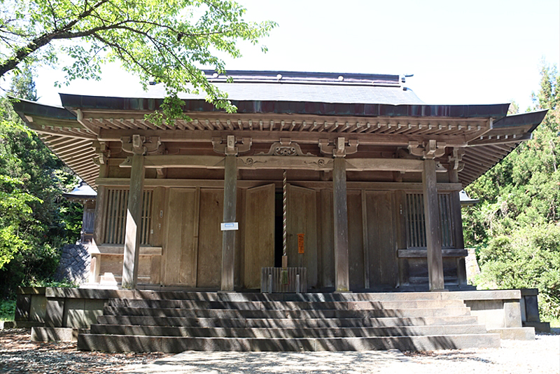
Mount Chokai Omonoki Shrine Fukiuraguchinomiya <Information>
- Facility name: Mount Chokai Omonoki Shrine Fukiuraguchinomiya
- Address: 1 Fukiura Nunokura, Yuza-machi, Akumi-gun, Yamagata Prefecture
- Phone number: 0234-77-2301
- Official URL: Chokaisan Omonoki Shrine
Google Map
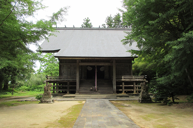
Chokaisan Omonoki Shrine Warabiokaguchinomiya <Information>
- Facility name: Chokaisan Omonoki Shrine Warabiokaguchinomiya
- Address: 51 Matsugaoka, Kamiwarabioka, Yuza-machi, Akumi-gun, Yamagata Prefecture
- Phone number: 0234-77-2301
- Official URL: Chokaisan Omonoki Shrine
Google Map
Sixteen Rakan Rocks carved into lava as a memorial for those who died in a maritime accident
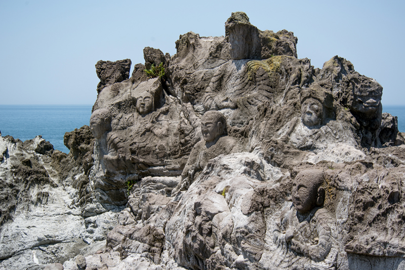
The Juroku Rakan Rock is a cliff-carved Buddha statue carved into lava that flowed from Mount Chokai, located on the coast near Fukiura Fishing Port facing the Sea of Japan. There are 22 Buddha statues carved into it, including 16 Rakan statues (saints who have reached the highest level of training), as well as Manjusri and Fugen Bodhisattva.
The rock-carved Buddha was carved mainly by the priest Kankai of Fukiura Kaizenji Temple as a memorial for fishermen who died in shipwrecks and to pray for safety at sea, and was completed in 1868
16 Rakan Rocks<Information>
- Facility name: Sixteen Rakan Rocks
- Location: Nishidate, Fukiura, Yuza-machi, Akumi-gun, Yamagata Prefecture
- Phone number: 0234-72-5666 (Yusa Chokai Tourism Association)
- Free admission
- access
- By car: Approximately 15 minutes from Yusahiko IC on the Nihonkai Tohoku Expressway
- Train: Approximately 15 minutes on foot from Fukiura Station on the JR Uetsu Main Line
- URL: 16 Rakan Rocks




![[Mount Chokai-Tobishima Geopark: Yurihonjo Edition] See the geological layers from when Japan was part of the Eurasian continent b5c46a18bc0cc79de0e9ad08084eaa5b](https://jp.neft.asia/wp-content/uploads/2024/04/b5c46a18bc0cc79de0e9ad08084eaa5b-150x150.jpg)
![[Mt. Chokai-Tobishima Geopark: Nikaho (2)] Coexistence with nature brought about by the wisdom of our ancestors 1 Nikaho Plateau, 2000, Nikaho City Cultural Properties Protection Division](https://jp.neft.asia/wp-content/uploads/2024/10/28389310d744abdc1b4ca5d863e123e7-150x150.jpg)
![[Mt. Chokai-Tobishima Geopark: Tobishima] Tobishima, which prospered during the Edo period due to the Kitamaebune shipping b78c09f26796b9608d6c3fb7a83ecc50](https://jp.neft.asia/wp-content/uploads/2023/05/b78c09f26796b9608d6c3fb7a83ecc50-150x150.jpg)
![[Mount Chokai-Tobishima Geopark: Nikaho Edition (1)] Kujukushima, which is considered to be on par with Matsushima but became land due to a major earthquake 1Kujukushima Winter 1_Nikaho City Tourism Division](https://jp.neft.asia/wp-content/uploads/2024/10/9832b69b3165ff52241c17ad3f8bf591-150x150.jpg)
![The Wooden Toy Museum is housed in an abandoned school! Access it by toy train [Yurihonjo, Akita Prefecture] 02 Mt. Chokai Wooden Toy Museum](https://jp.neft.asia/wp-content/uploads/2018/11/cce286efc423e9c7e7b7514902aaaac3-150x150.jpg)

