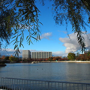
Cape Shiosezaki, located on the southwestern tip of the Oga Peninsula, where Godzilla and Gamera live, and Unosaki Coast, also known as Akita's Uyuni Salt Flats (Akita Prefecture)
table of contents
- 1 Cape Shiosezaki, located at the southwestern tip, where you can see the battle between Godzilla and Gamera about to begin
- 2 "Gamera Rock" is looking for an opportunity to challenge Godzilla to a fight
- 3 "Godzilla's Tail Rock" that looks just like a tail
- 4 The precious "Twin Rocks" where you can see a glimpse of Earth's activity
- 5 Fukake Island has been a tourist attraction since the Edo period
- 6 "Green Tuff" is an exposed rock that has turned green due to Earth's activity
- 7 "Candle Rock" changed shape about 50 years ago
- 8 A photogenic spot on SNS: Unosaki Coast, "Akita's Uyuni Salt Flats"
Nyudozaki at the northern tip of the Oga Peninsula . Nyudozaki Lighthouse, a rare lighthouse that can be climbed, sits atop a hill offering a panoramic view of the Sea of Japan. The nearby coast is the "Shika Otoshi" and "Oni no Tawara Korogashi," as well as a monument marking the 40th parallel north. 40 degrees north is at the same latitude as Beijing (China), Philadelphia (USA), and, slightly further away, New York (USA). Nearby is Oga Onsenkyo , where you can enjoy natural hot springs. It also offers accommodation and restaurants serving stone-grilled cuisine, making it the most popular tourist destination on the Oga Peninsula.
The west coast of the Oga Peninsula has a unique shape with a coastline full of sheer cliffs and almost no sandy beaches. This is why the Osanbashi Pier and Butaijima Island , which were carved out of rocks tens of millions of years ago by the waves.
Cape Shiosezaki, located at the southwestern tip, where you can see the battle between Godzilla and Gamera about to begin
Cape Shiosezaki, located at the southwestern tip of the Oga Peninsula, a wave-cut platform (wave-cut shelf) that was originally formed by shallow seabed rocks that were flattened by the waves, and then rose slightly to appear above sea level.The terrain is relatively flat, but you can see many rugged rock masses on top of it.
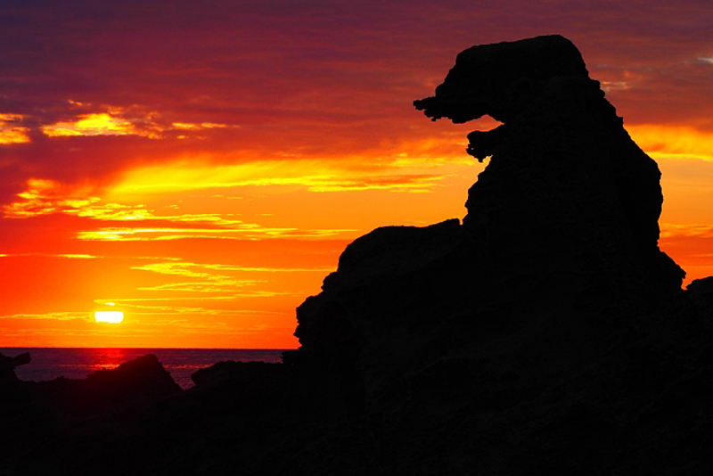
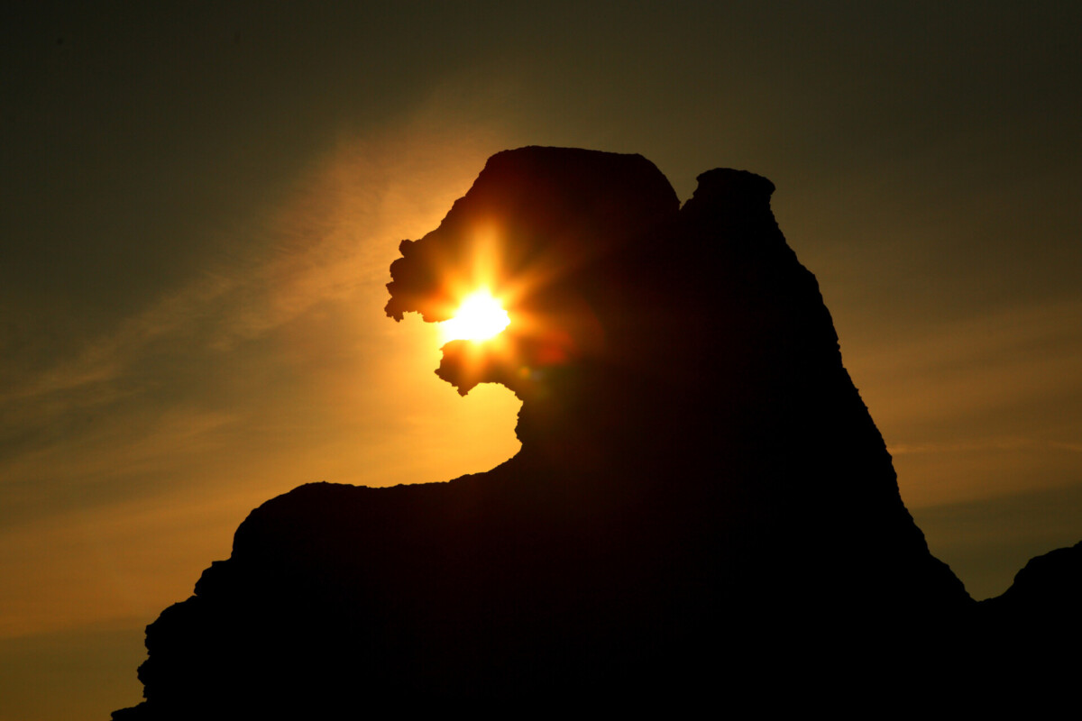
"Godzilla Rock" is the first thing that catches your eye.
This rock resembles Godzilla even when viewed normally during the day, but in the evening on a sunny day, its appearance changes dramatically. With the sunset as the backdrop, it looks as if it is spewing fire from its mouth, and when the sun enters its mouth, it looks as if it is eating fire, and as dusk approaches, it appears as if it is disappearing into the sea. Even if you're not a Godzilla fan, you'll enjoy watching this moving scene unfold before your eyes forever. Godzilla is truly a world-famous actor
"Godzilla Rock" was named by a local resident who saw the rock bathed in the sunset in 1996 (Heisei 8) because the black silhouette of the rock looked like it was breathing fire just like Godzilla. The best season to see "fire-breathing Godzilla" is around October , and "sun-eating Godzilla" is around April .
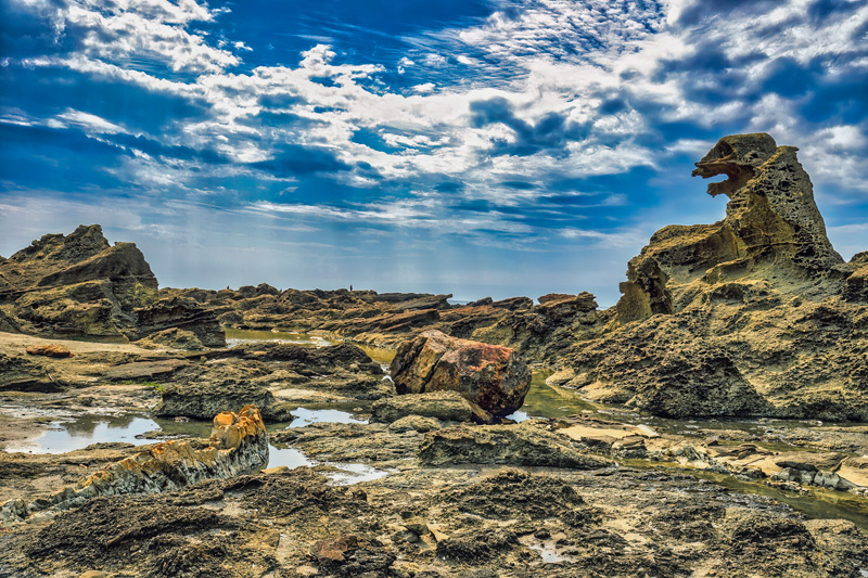
The base of Godzilla Rock is made up of tuff when rock erupted from a volcano 30 million years ago and hardened.Even when the lapilli tuff was eroded and flattened by the waves, a volcanic breccia .
"Gamera Rock" is looking for an opportunity to challenge Godzilla to a fight
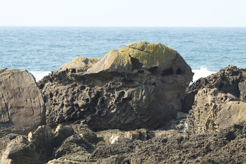
At Cape Shiosezaki, Gamera is hiding near Godzilla. The battle between Godzilla and Gamera has not yet happened (Godzilla = Toho, Gamera = Daiei, so the showdown has not yet happened. It's an adult matter), but here Gamera has turned into a rock and is aiming at Godzilla in preparation for the battle
Unlike Godzilla Rock Gamera Rock is
"Godzilla's Tail Rock" that looks just like a tail
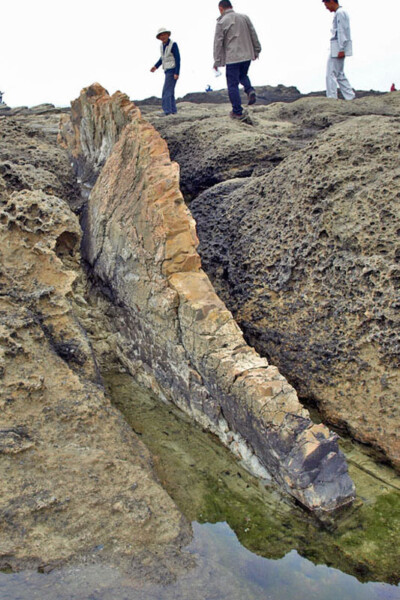
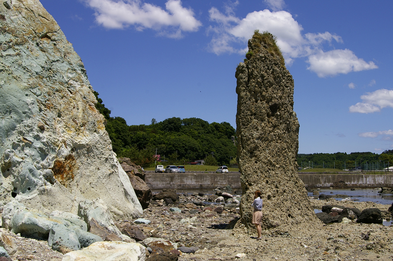
"Godzilla's Tail Rock" was named after the long, thin rock sticking out from the bedrock, which looks like Godzilla's tail.
Godzilla's Tail Rock was formed when volcanic ejecta rained down on soft mud, causing the mud to pile up under its weight. The originally soft mud was layered with large amounts of ash and rocks over a long period of time, turning it into hard mud (mudstone). The area where Godzilla's Tail Rock is located was originally the seabed, and it is believed that the soft volcanic lapilli tuff was worn away by the erosion of waves, leaving only the hard mudstone as Godzilla's Tail Rock, which then rose to the surface
Although Godzilla Rock, Gamera Rock, and Godzilla Tail Rock are located very close to each other, they are all made of different rocks. In addition to these three rocks, Cape Shiosezaki is home to many other rocks of various shapes. Cape Shiosezaki is truly an "art museum of the Earth."
The precious "Twin Rocks" where you can see a glimpse of Earth's activity
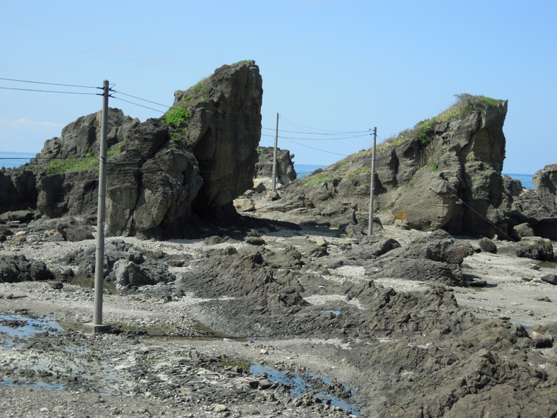
The "Futago Rocks" are two similarly shaped rocks standing side by side near "Godzilla Rock." These rocks are not only famous for their similar shapes, but also have historical and geological value, as they show traces of lava (dolerite) that rose 10 million years ago and intruded vertically (dykes) and horizontally (sills) into the 30 million year old volcanic lapilli tuff.
Fukake Island has been a tourist attraction since the Edo period
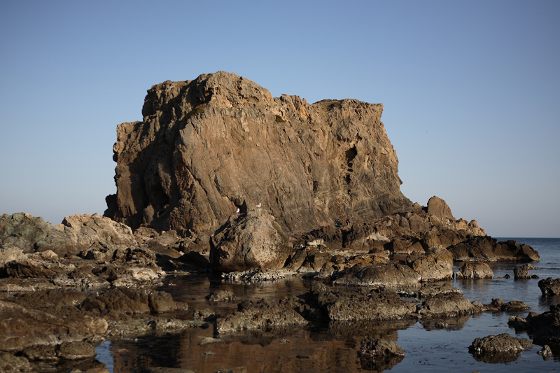
"Hokakejima" is an island, it is actually a large rock that is connected to the mainland. the "Oga-zu byobu" (Oga Screen) , painted in the early Edo period, it is depicted as a complete island and is named "Hokakejima ," so it is believed that it rose up and became connected to the mainland over the course of 400 years.
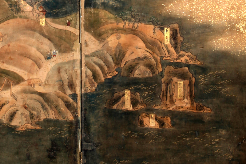
The name "Fukake Island" is said to have been given to the rock because its shape resembles the shape of a sailing ship, such as the Kitamae-bune, sailing with its sails unfurled. Unlike "Godzilla Rock" or "Gamera Rock," this name has a long history
Fukake Island is a gigantic monolith about 30 meters high and over 60 meters wide, made of volcanic tuff that is about 30 million years old. It is shown as an island on Google Maps, but when I inquired with Oga City Hall, they told me that it has never been an island, even during high tides
Fukake Island Google Maps
"Green Tuff" is an exposed rock that has turned green due to Earth's activity
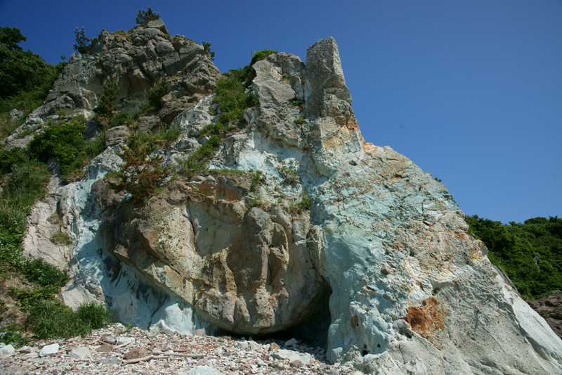
Tateyamazaki about 2km east of Shiosezaki, at the southwestern tip of the Oga Peninsula, along the coastline (Oga Sea Breeze Highway) . This area is also known as a treasure trove of strangely shaped rocks.
"Green Tuff" is not an individual rock, but a general term for cliffs with exposed rocks on their slopes. It is called green tuff because the exposed rocks are green, with tuff meaning tuff. Green tuff is thought to be a volcanic eruption from 21 million years ago. There are many places on the Sea of Japan side where green tuff is exposed, but the one at Tateyamazaki is extremely rare due to its large scale and vivid color.
At Cape Tateyama "Tsubaki no Shiroiwa" (White Rock of Camellia) , which is made of white tuff. Tuff is originally white in color, but when it erupts from the volcano, some of the components in the rock change and it turns green.
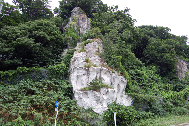
"Candle Rock" changed shape about 50 years ago
"Candle Rock" is a long, thin rock that stands like a candle near the green tuff. Until about 50 years ago, this rock was called "Kannon Rock" . However, due to the seasonal winds, rain, and snow that are unique to the Tohoku region, it was weathered, and eventually the top part fell off, giving it the name "Candle Rock" that we know today.
A photogenic spot on SNS: Unosaki Coast, "Akita's Uyuni Salt Flats"
Finally, although it's not a strange rock formation, we'd like to introduce a spot that is currently very popular on social media
Unosaki Coast is located in the center of the southern coast of the Oga Peninsula, about 5km from Tateyamazaki along the Oga Sea Breeze Highway and about 5km from JR Oga Station. It is a beautiful coastline that has attracted attention as "Akita's Uyuni Salt Flats."
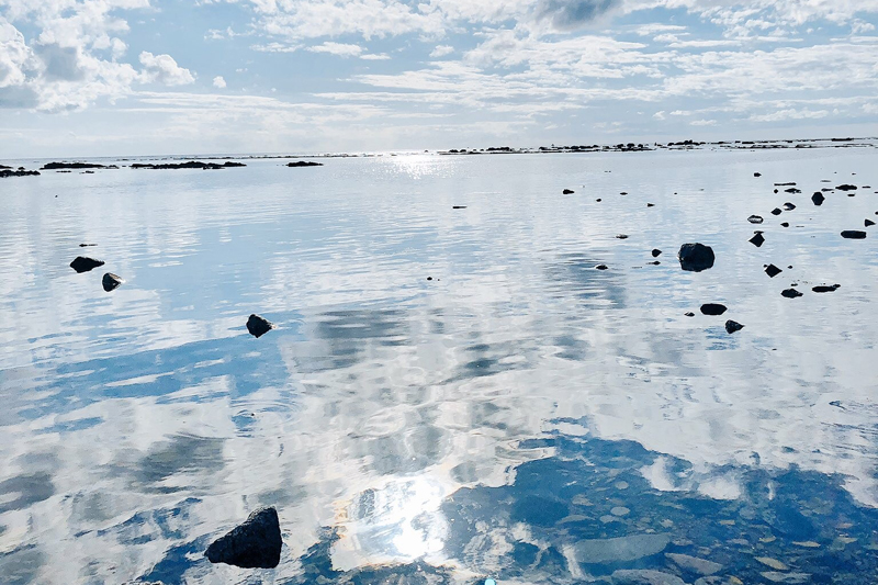
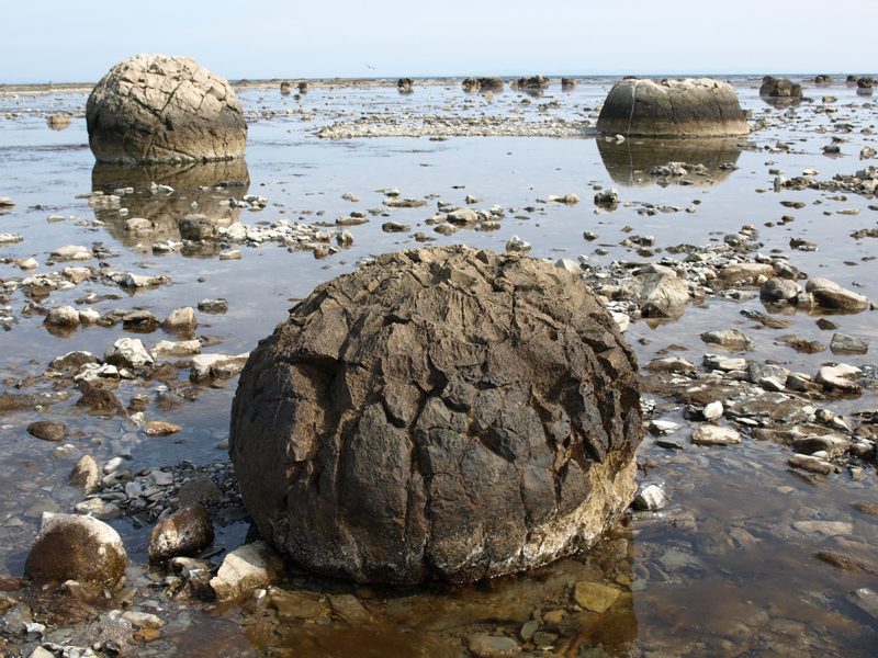
Although Unosaki is a coast, it is not a sandy beach. a "wave-cut platform" , and at low tide, flat rocks appear above sea level, allowing you to walk out to sea (but be careful of the tide times).
The rocks sink into the sea, and on clear, calm days the surrounding scenery is reflected on the water's surface, creating a chance to take beautiful photos and videos that resemble those of the Uyuni Salt Flats in Bolivia, South America. This photogenic spot is extremely popular and often appears on social media
At Unosaki Sea Coast, the "Devil's Washboard " and the "Azukiiwa ." Nowadays, Unosaki Coast at the "Uyuni Salt Flats" has been overshadowed, but if you visit Unosaki Coast, be sure to stop by.
Cape Shiose, Cape Tateyama, and Unosaki Coast <Information>
- Phone number: 0185-24-4700 (Oga City Tourism Association)
- URL: Oganavi
- access:
- Train: Take a taxi from Oga Station on the JR Oga Line, or rent a car near Oga Station
- By car: Approximately 50 to 70 minutes from Showa Oga Peninsula IC on the Akita Expressway
Google Maps
Like the Candle Rock, the strange rock formations we have introduced may disappear tomorrow due to weathering, natural disasters such as earthquakes and typhoons, or even human development. Why not come and enjoy the Oga Peninsula now?
Oga Peninsula/Ogata Geopark <Information>
- Oga Peninsula/Ogata Geopark
- URL: Oga Peninsula-Ogata Geopark


![[Oga Peninsula, Akita Prefecture] Strange rock formations on the west coast where ancient legends are passed down Rocky landscape on the west coast of the Oga Peninsula ©Oganavi](https://jp.neft.asia/wp-content/uploads/2024/04/8764aeda3bb4db1829041fa671d1b72d-150x150.jpg)
![Did Namahage really exist? Traces of demons remain throughout the Oga Peninsula - Oga Peninsula and Demon Legends (2) [Akita Prefecture] 1. Namahage Sedo Festival](https://jp.neft.asia/wp-content/uploads/2024/09/1076350e647a6476081bad8cd4fd6159-150x150.jpg)
![[Oga Peninsula, Akita Prefecture] Full of Viewpoints. Oga Peninsula, a Magnificent Park Created by the Earth 3d84cc3d4a133d89422d448f000c277b](https://jp.neft.asia/wp-content/uploads/2024/04/3d84cc3d4a133d89422d448f000c277b-150x150.jpg)
![[Part 2] Masumi Sugae's Walk around the Oga Peninsula - Fascinated by the strange rock formations along the coast [Akita Prefecture] 1 Shimakaze of Oga - 891-1 Manuscript in the possession of Akita Prefectural Museum](https://jp.neft.asia/wp-content/uploads/2024/10/8dafd7ea0a7bd28f76a6f059db39c9de-150x150.jpg)

![The popular "Matagi" tradition of wild game began in Kitaakita City! [Akita Prefecture] matagi](https://jp.neft.asia/wp-content/uploads/2024/04/matagi-150x150.jpg)
![Why do Namahage carry blades and punish people? - Oga Peninsula and Demon Legends (1) [Akita Prefecture] New Year's Eve Event 001@OGA City](https://jp.neft.asia/wp-content/uploads/2024/10/00bf8a32651033edd1191ba2d04c6f61-150x150.jpg)
