This site is an online media that delivers all sorts of trivia about the six Tohoku prefectures, from sightseeing and gourmet spots to local customs, history, and more
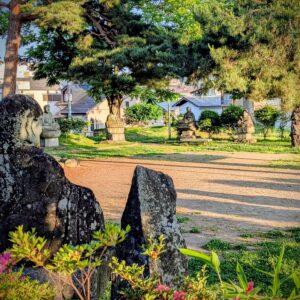
Kisakata-Takujukushimais a scenic spot located on the Sea of Japan coast in Nikaho City, at the northern foot of Mount Chokai, which straddles the border between Akita and Yamagata prefectures. Small, island-like hills dot the landscape amidst sprawling rice paddies, creating a beautiful scenery reminiscent of Matsushima (Matsushima Town, Miyagi Prefecture), one of Japan's three most scenic spots, but on land.
Edo period travel writersMatsuo BashoandSugae Masumiwere also deeply impressed by Kisakata and the Kujukushima Islands, and praised their beauty. However, there is a significant difference between the landscape of Kisakata and the Kujukushima Islands that we see today and the landscape that Basho and Masumi saw.
The scenery of Kisakata, which has been praised alongside Matsushima since the Heian period
Kisakata and the Kujukushima Islands were featured in waka poetry by poet Noin, who compiled a list of famous places and historical sites (utamakura) from all over Japan during the Heian period, and by the monk Saigyo of the same period, and were known as a spectacular sight in the Tohoku region even during the Edo period
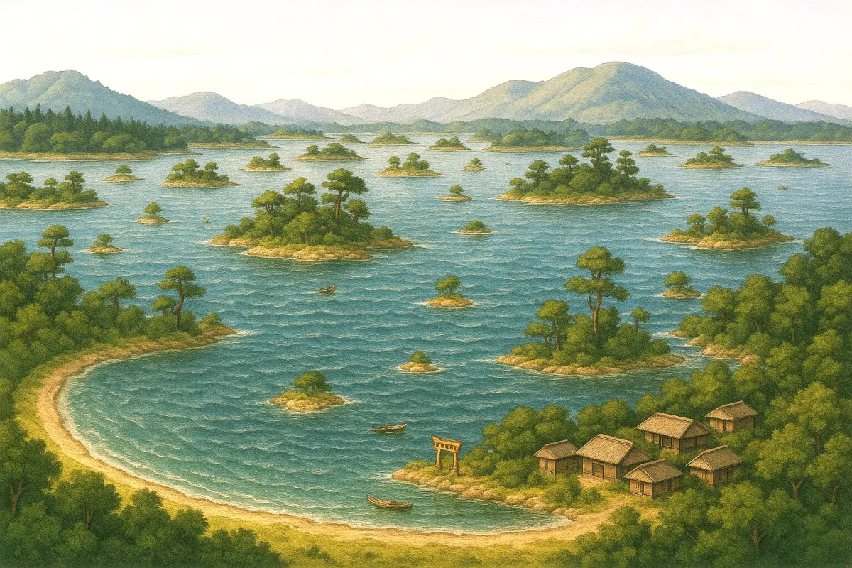
What Basho and Masumi saw was a landscape of small islands floating in the sea, similar to Matsushima.We can no longer see it, but fortunately, illustrations and drawings from the Edo period remain, allowing us to glimpse its appearance.
Did Basho's "Oku no Hosomichi" travelogue begin because he wanted to see Kisakata?
Matsuo Basho left behind a travelogue, " Oku no Hosomichi" (The Narrow Road to the Deep North) , which mainly covers the Tohoku region , and many of the places he visited are places that were mentioned in poetry by Nōin
On March 27, 1689 (according to the old calendar; April 16 in the modern solar calendar; hereafter, "Oku no Hosomichi" will use the old calendar), at the age of 46, he departed by boat from Fukagawa in Edo (present-day Fukagawa, Edogawa Ward, Tokyo) with his discipleKawaiSora, and from Senju (present-day Senju, Adachi Ward, Tokyo), he walked north.
He traveled through Saitama, Tochigi, and Fukushima prefectures, and was deeply moved by Matsushima in Miyagi Prefecture ("Matsushima, ah Matsushima, Matsushima" is attributed to his disciple Tahara-bo, but the prevailing theory is that it was actually written by him).
Later, in Hiraizumi (Hiraizumi Town, Iwate Prefecture), where the Oshu Fujiwara clan flourished during the Heian period, he gazed upon the site of Minamoto no Yoshitsune's death and composed the haiku " Summer grasses, the remnants of warriors' dreams ." He then crossed the Ou Mountains into Yamagata Prefecture and visited the Dewa Sanzan (Mt. Gassan, Mt. Haguro, and Mt. Yudono) and Yamadera (Risshakuji Temple). At Yamadera, he left behind the famous haiku " Silence, the cicada's cry seeping into the rocks ."
Leaving the mountain temple behind, the group traveled down the Mogami River by boat ("Gathering the May rains, the Mogami River flows swiftly") and arrived in Sakata (Sakata City, Yamagata Prefecture), the largest port town on the Sea of Japan side of Tohoku.
The group arrived in Sakata on June 13, 1689 (Genroku 2), and set off for Kisakata on June 15. "Oku no Hosomichi" is a journey that visits increasingly distant destinations, but Kisakata was the only destination that was planned to depart from Sakata and return to Sakata three days later
It is said that Kisakata was the main destination on "Oku no Hosomichi" because it was a landscape that Basho desperately wanted to see
Despite the heavy rain, we made it through the difficult mountain pass and arrived at Kisakata
The road to Kisakata runs along the Sea of Japan, where the base of Mt. Chokai sinks into the sea. "View of the sea from Minamihikarizaka, Shindo-no-uchi, Fukiura Village, Akumi County." Property of Yamagata Prefectural Library
To get from Sakata to Kisakata, you have to go through the foot of Mount Chokai, which towers north of Sakata, and cross three mountain passes
Mt. Chokai is a rare mountain with its base rising directly from the Sea of Japan, and the coast is lined with steep cliffs. The road at the time was built right on the sea's edge, making it extremely dangerous depending on the weather
Furthermore, on the border with Akita Prefecture, there are three capes (Kannonzaki, Daishizaki, and Fudozaki) formed by lava from the eruption of Mount Chokai. Although their elevation is not particularly high, these are also known as challenging mountain passes.
Even though he was physically fit, crossing the mountain pass required considerable resolve for the middle-aged Basho. However, Kisakata was a place he longed tovisit so much that he wrote,I have seen countless beautiful landscapes of rivers, mountains, seas, and land, but now the thought of seeing Kisakata fills me with excitement." He set off without paying any attention to the difficult sections of the pass.
The group left Sakata in the morning and arrived in Fukuura (Yuza Town, Yamagata Prefecture), just before Mount Chokai, in the early afternoon. Heavy rain fell, forcing them to stay overnight in Fukuura and wait for the weather to improve. However, the next morning it rained again. Still, Basho, eager to get to Kisakata, forced himself to leave
Due to a storm, they were forced to take temporary refuge in a boathouse at Uyamaya no Seki, which is said to be on the prefectural border, but they managed to arrive at Kisakata that same day
Information
Facility name: Misaki Old Highway (Misaki Park)
Location: Kosagawa Misaki, Kisakata-cho, Nikaho City, Akita Prefecture
Phone number: 0184-43-6608 (Nikaho City Tourism Association)
Access: Public transport: Approximately 15 minutes by car from Kisakata Station on the JR Uetsu Main Line. Car: Approximately 15 minutes from Kisakata IC on the Nihonkai Tohoku Expressway
Google Map
Basho compared the beauty of Kisakata to that of the unparalleled beauties of ancient China
"Ushu Zokagata no Zu" (Map of the Kujuku Islands), which Basho described as a peerless beauty so beautiful it could destroy a country. Collection: Ishimoto Collection, University of Tokyo
Upon arriving in Shiokoshi Village (Shiokoshi, Kisakata-machi, Nikaho City), where Kisakata is located , I visited Notoya, where I had planned to stay, changed clothes, ate udon noodles, and then, despite the rain still falling, set out to explore Kisakata and the Kujukushima Islands.
We set sail on the sea off Kisakata and crossed to Noin Island, where Noin, who was fond of Kisakata, is said to have spent three years
Basho and his companions returned to Notoya, but because it was the day of the Shiokoshi festival, there were no rooms available, so they stayed at an inn called Mukaiya. The next morning it rained at first, but it gradually cleared up, and theyKanmanji Temple, and after dinner they took a boat tour of the bay, fully enjoying Kisakata. They returned to Sakata the following day, June 18th.
Basho was inspired by the scenery of Kisakata and Kujukushima, and left behind several poems
“In the rain, Xi Shi is blooming with the flowers of the Japanese snowbell”
Basho describes the beauty of Kisakata by comparing it to an ancient Chinese woman named Xishi, who was so beautiful that her king became obsessed with her beauty that he ended up destroying his country. He also writes that while Matsushima has a bright, sunny landscape that seems to smile, Kisakata has a dark, melancholic, resentful quality
95 years after Basho's visit, in 1784, the travel writer Sugae Masumi visited Kisakata and, upon seeing the same scenery that Basho had seen, praised it highly in his book " Akita no Karine (齶田濃刈寢)"
The Kisakata earthquake completely transformed the sea into land in one day
Twenty years after Sugae Masumi's visit, on July 10, 1804 (solar calendar), an earthquake with an estimated magnitude of 7.0 struck the Kisakata region. The landscape of the Kujukushima Islands was completely transformed in just one day. The islands that had previously been floating in the sea were transformed into small hills scattered across the land
The earthquake caused the land of Kisakata to rise by about 2 meters. The area that was once shallow sea dried up, becoming a reclaimed land
Kisakata suffered catastrophic damage from this earthquake, but the Honjo Domain, which controlled Kisakata, quickly focused on reconstruction. They received a temporary loan from the Edo shogunate and began rebuilding the village and cultivating the uplifted land. Records from 1846, about 40 years after the earthquake, mention that "where the lagoon used to be, it has become rice paddies," indicating that rice fields had spread across what was once the Kujukushima Islands.
Access: Public transport: Approximately 15 minutes on foot from Kisakata Station on the JR Uetsu Main Line. Car: Approximately 8 minutes from Kisakata IC on the Nihonkai Tohoku Expressway
Google Map
Kakurin put a stop to the disaster at the risk of his life to protect the landscape of Kisakata and Kujukushima
The Honjo Domain must have found the small hill that was an island to be a hindrance, so they started to demolish the mountain and cultivate the land
However, those who could not forget the scenery of the Kujukushima Islands, with their small islands rising from the water's surface, objected to this policy. In particular, Kakurin, the 24th head priest of Rutsumanji Temple,repeatedly submitted petitions to the domain, arguing that Rutsumanji Temple had long been entrusted with Kisakata as temple territory, but his requests were not granted.
Kakurin came up with a plan. If Rumanji Temple became a temple connected to the Imperial family (the Emperor and the Imperial Family), the domain would not be able to lay hands on the Kujukushima Islands, which were temple land. After much effort, he succeeded in making Rumanji Temple a place of prayer for the Kan'innomiya family, and he persuaded the domain to stop the demolition of the hill
However, Kakurin's actions enraged the clan, and he was pursued for disobeying the clan's orders. Sensing danger, Kakurin fled to Kan'ei-ji Temple in Ueno, Edo (located in Taito Ward, Tokyo), but was discovered and taken back to Honjo, where he was imprisoned
Kakurin died in prison in 1822. Thus, the landscape of Kujukushima has survived to this day in exchange for Kakurin's death
Information
Facility name: Kanmanji Temple
Address: 2 Kisakatajima, Kisakatacho, Nikaho City, Akita Prefecture
Access: Public transport: Approximately 15 minutes on foot from Kisakata Station on the JR Uetsu Main Line. Car: Approximately 8 minutes from Kisakata IC on the Nihonkai Tohoku Expressway
Google Map
Nikaho City Local History Museum exhibits historical documents and old maps of Kisakata
TheNikaho City Kisakata Local History Museumthe drastically altered landscape of the Kujukushima Islands after the Kisakata earthquake through a folding screen painting depicting the islands before the uplift, titled "Paper Painting of the Kisakata Landscape," and a 1/825 scale model of the islands.
The museum also displays materials related to Matsuo Basho's "Oku no Hosomichi," as well as Shiokoshi Port, which flourished as a port of call for Kitamaebune (merchant ships that conducted large-scale business between Tohoku, Hokkaido, and Kansai, traveling through ports on the Sea of Japan) from the Edo to Meiji periods
Information
Facility name: Nikaho City Kisakata Local History Museum
Address: 31-1, Kitsumori, Kisakata-cho, Nikaho City, Akita Prefecture
Access: Public transport: Approximately 3 minutes by car from Kisakata Station on the JR Uetsu Main Line. Car: Approximately 3 minutes from Kisakata IC on the Nihonkai Tohoku Expressway
My love of travel led me to work for a travel magazine some time ago, and now I work as a travel writer for an online publication. I have visited all 47 prefectures in Japan, focusing on the Tohoku region, and I enjoy soaking in hot springs and experiencing traditional Japanese culture, including old townscapes, lifestyles, and performing arts and crafts


] Kujukushima, which is considered to be on par with Matsushima but became land due to a major earthquake")
] Kujukushima, which is considered to be on par with Matsushima but became land due to a major earthquake")


] Coexistence with nature brought about by the wisdom of our ancestors")

")