This site is an online media that delivers all sorts of trivia about the six Tohoku prefectures, from sightseeing and gourmet spots to local customs, history, and more
In Fukushima Prefecture, the southernmost of the six Tohoku prefectures, autumn leaves are at their peak in the mountainous region of Aizu and the highlands of Urabandai
Among them, in the warmer Hamadori and Nakadori areas, many areas are just starting to change color, and you can enjoy a drive to see the autumn leaves from mid- to late November
Lake Numazawa, Lake Tadami, and Lake Tagokura (Kanayama Town and Tadami Town, Onuma District: National Route 252)
Lake Numazawa Source: Fukushima Tourism Information Site "Fukushima Travel"
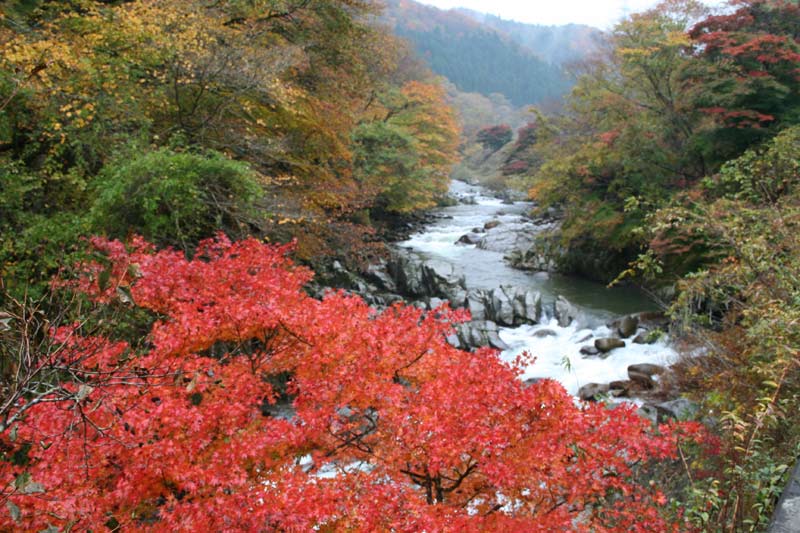
The approximately 50-kilometer stretch from Kaneyama town in the Oku-Aizu region to Tadami town on the border with Niigata prefecture is a pleasant autumn foliage drive along the gorge created by the Tadami River.
The 5th Tadami River Bridge over the Tadami River in Kanayama Town. Source: Fukushima Tourism Information Site "Fukushima Travel"
The Tadami River has an abundant amount of water, and along its 50-kilometer stretch there are five hydroelectric dams: Ueda, Honna, Taki, Tadami, and Tagokura. Each dam lake offers a beautiful view colored by autumn leaves
Lake Numazawa born from a caldera
Lake Numazawa Source: Fukushima Tourism Information Site "Fukushima Travel"
This caldera lake was created by the eruption of Numazawa Volcano and is 96 meters deep at its deepest point. During the autumn foliage season, the area around it is painted in vibrant reds and yellows for about 7 kilometers
In addition to parks and campgrounds on the lakeside, there are also facilities such as the Kanayama Town Fairy Art Museum, where you can enjoy a relaxing time surrounded by nature while viewing the autumn leaves
To get to the shore of Lake Numazawa from National Route 252, take Prefectural Route 237 or the town road "Fairy Road" from near Aizu-Nakagawa Station on the JR Tadami Line
Oshio Natural Carbonated Water Spring and Takizawa Natural Carbonated Water Spring
Kanayama Oshio Natural Carbonated Water Source: The Ultimate Aizu Project Council Official Website
Along National Route 252 in Kaneyama Town , there are two spots where natural carbonated water springs forth, a rarity in Japan. You can collect soft water with a mild, smooth taste
Carbonated water bubbling up with bubbles. Source: The Official Website of the Aizu Project Council
Of these, the carbonated water from "Oshio Natural Carbonation Spring" is bottled and sold at nearby stores, and is also used as a return gift for Kaneyama Town's hometown tax donation program.
Bottled carbonated water Source: The Ultimate Aizu Project Council Official Website
Another source, "Takizawa Natural Sparkling Water," is also available for drinking, but it's not very well-maintained, so if you're concerned about that, we recommend the sparkling water from Oshio.
Tagokura Dam and Lake Tagokura Source: Fukushima Tourism Information Site "Fukushima Travel"
The 145-meter-high Tagokura Dam in Tadami Town is one of the largest hydroelectric dams in Japan, along with the Okutadami Dam further upstream
Lake Tagokura, a reservoir created by a dam, is located within the Echigo Sanzan Tadami Quasi-National Park and is known as a famous spot for autumn foliage. In 2005, it was selected as one of the "100 Best Dam Lakes."
Tadami Dam seen from the direction of Tagokura Dam Source: Official website of the Gokujo Aizu Project Council
Furthermore, the Tadami Dam, located just downstream from the Tagokura Dam, was constructed as a " reverse regulating reservoir " to adjust the amount of water released from the Tagokura Dam
Because they are so close together, you can see each other from the top of both dams
Soba Yakimochi Source: Fukushima Tourism Information Site "Fukushima Travel"
This is a local dish from the Aizu region, made by wrapping bean paste and wild vegetables in a dough made from a mixture of buckwheat flour and glutinous rice flour, then steaming and baking it
The chewy, elastic skin has a subtle buckwheat aroma, and the fillings include bean paste, butterbur, and nozawana
It is made by Yamasa Shoten, a shop in Tadami town known for its 100% handmade soba noodles, and can be enjoyed at nearby restaurants such as Yasori-an, and is also recommended as a souvenir
Nanko Park and Shirakawa Komine Castle (Shirakawa City: National Routes 294 and 289)
Nanko Park Source: Fukushima Tourism Information Site "Fukushima Travel"
Shirakawa City, known for the Shirakawa Barrier, has several famous spots for viewing autumn foliage, including Shirakawa Komine Castle and Nanko Park
Furthermore, there are many famous spots for viewing autumn foliage along the Abukuma River that flows through the city, and Yukiwaribashi Bridge and Kashio-ohashi Bridge in the neighboring Nishigo Village are also popular destinations.
Koshi Bridge in Saigo Village Source: Fukushima Tourism Information Site "Fukushima Travel"
These famous autumn foliage spots, including the Shirakawa Barrier ruins, are far apart, so when visiting them, it's a good idea to enjoy a drive through the city, where you can feel the history of the area
Nanko Park, Japan's oldest park
Statue of Matsudaira Sadanobu in Nanko Park Source: Fukushima Tourism Information Site "Fukushima Travel"
Nanko Park is considered to be Japan's first park , created and opened to the public in 1801 (Kyowa 1) by Matsudaira Sadanobu, the lord of the Shirakawa domain at the time
Nanko Park Source: Fukushima Tourism Information Site "Fukushima Travel"
It is a popular resting spot for Shirakawa residents, where you can enjoy cherry blossoms in the spring, fresh greenery in the summer, and autumn leaves in the fall. You can drive close to the lakeside on the north side of the lake
Nanko Park<Information>
Facility name: Nanko Park
Location: Nanko, Shirakawa City, Fukushima Prefecture
Phone number: 0248-22-1111 (main number) (For inquiries, please contact the Shirakawa City Hall Tourism Division)
Shirakawa-Komine Castle Source: Fukushima Tourism Information Site "Fukushima Travel"
Komine Castle, one of Japan's 100 Famous Castles , was the site of fierce battles during the Boshin War, and at one point, all the buildings were destroyed, leaving only the stone walls. However, the castle tower and other structures were later restored.
Castle tower and autumn leaves of Zelkova. Source: Fukushima Tourism Information Site "Fukushima Travel"
The contrast between the white walls of the castle tower and the red zelkova trees is very beautiful
Both locations have parking lots, so you can enjoy viewing the autumn leaves at your own pace
"Shirakawa Ramen" is famous throughout the country
Tora Shokudo's Original Shirakawa Ramen Source: Fukushima Tourism Information Site "Fukushima Travel"
It is characterized by a light soy sauce-flavored soup made with pork bone and chicken stock and hand-made curly noodles, and is a famous local ramen restaurant throughout the country, with over 100 stores in the city and the number of stores in the Tokyo metropolitan area also increasing
Using " Tora Shokudo ," the original restaurant in the city , as a benchmark, why not try comparing the flavors of each restaurant, each with its own unique twist?
For more information about Shirakawa ramen, please see this article
Natsuigawa Valley (Iwaki City: Prefectural Route 41 Ono-Yotsukura Line)
Natsuigawa Valley Source: Fukushima Tourism Information Site "Fukushima Travel"
It is close to the outskirts of Iwaki city, and you can enjoy a drive to view the autumn leaves from early to late November
The valley stretches for about 15 kilometers along the JR Ban'etsu East Line and a prefectural road, and is known as a famous cherry blossom viewing spot in spring
Natsuigawa Valley Source: Fukushima Tourism Information Site "Fukushima Travel"
There are many narrow sections of the road within the valley, so you need to be careful when passing large vehicles. There is also little parking along the road, so you need to be careful when parking or getting out of your car
the Natsui River Gorge Campground parking lot andto Setogaro, please use the Natsui River Valley Nishiki Observation Deck parking lot.
Natsuigawa Valley <Information>
Name: Natsuigawa Valley
Location: Kami-Ogawa to Kawamae, Ogawa-cho, Iwaki City, Fukushima Prefecture
During the autumn foliage season, a wide variety of seafood is landed at Onahama Port in Iwaki City, but the fish we especially recommend is the "mehikari," which is known as the "city fish.
Mexicali, with its large, glowing blue eyes, can be caught almost all year round except during closed fishing seasons, and its mild, soft white flesh can be eaten whole, fried, in tempura, or dried
There are restaurants in Iwaki City that serve raw Mexicali as sashimi or sushi, so why not try it on your way to or from the Natsuigawa Valley?
Fukushima Prefecture has a wide range of autumn foliage seasons due to the differences in climate between the mountainous and highland areas of Aizu, the inland Nakadori area, and the coastal Hamadori area, and the types of broad-leaved trees are also different, so the colors vary as well
In this article, we have introduced roads in these three regions where you can still enjoy a drive to see the autumn leaves
Be sure to visit all three and experience the difference with your own eyes and skin
I'm a former Edoite (Tokyoite) who loves Morioka and the six prefectures of Tohoku, and I'm a big fan of history, gourmet food, travel, sports, alcohol, and choral singing.
I'll introduce you to interesting things, delicious food, and great places in Tohoku!


![What are the Mogami Eight Shields? [Part 2]](https://jp.neft.asia/wp-content/uploads/2026/04/my_ic02-300x300.jpg.webp)

