This site is an online media that delivers all sorts of trivia about the six Tohoku prefectures, from sightseeing and gourmet spots to local customs, history, and more
New discoveries are being made one after another! Juniko Lakes, a collection of 33 lakes and marshes in the forests of the Shirakami Mountains (Aomori Prefecture)
New discoveries are being made one after another! Juniko Lakes, a collection of 33 lakes and marshes in the forests of the Shirakami Mountains (Aomori Prefecture)
Juniko (Twelve Lakes) is a collective name for an area in southwestern Aomori Prefecture where many lakes and ponds nestle in a forested area at an altitude of around 150m, continuing from the Shirakami-Sanchi World Heritage Site. There are 33 lakes in total, but the name is "Juniko." Apparently, when looking out over this area from the top of Ookuzure, a landslide scar that occurred midway up Mount Kuzureyama (approximately 940m above sea level) at the western edge of the Shirakami-Sanchi, 12 lakes can be seen through the trees, and so the area came to be called "Juniko" even though there are actually 33 lakes
Hirosaki University's discovery that changed the history of Juniko
Kuzureyama is a mountain with soft ground that frequently experiences landslides, and Juniko Lake was formed when a stream was blocked by one of these landslides.Until recently, it was thought that the cause of its formation was a major earthquake that occurred in 1704 (the first year of the Hoei era)
In April 2023, a group led by Associate Professor Zou Qingying (Faculty of Agriculture and Life Sciences) of Hirosaki University announced a new fact: "Lake Juniko did not appear during the great earthquake of 1704 (the Hoei Iwadate earthquake), but had already been formed by a landslide that occurred between 1440 and 1660." The Hoei Iwadate earthquake was a large earthquake with a magnitude of 6-7, which also caused a landslide on Mount Kuzureyama, leaving traces of the collapse that can still be seen today, but it was found that the impact on Lake Juniko was minimal
Associate Professor Zou specializes in erosion control, which studies the mechanisms of landslides and sediment-related disasters, and began investigating Lake Juniko in 2018 with the primary goal of studying disaster prevention and mitigation. In particular, he was successful in deciphering past landslides from tree rings, which led to this discovery. However, as this research has only just begun, new developments are expected in the future
The Shirakami-Sanchi area was formed by uplift after an undersea volcano erupted
Why are there so many landslides in the Juniko Lake area? The reason has more to do with the history of the Shirakami-Sanchi area that continues from Juniko Lake, rather than the Juniko Lake area itself. The Shirakami-Sanchi was once the bottom of the sea, before the Japanese archipelago was formed in ancient times. Approximately 5 million years ago, it emerged as land due to active undersea volcanic activity and uplift. The geology is made up of deposits of lava, sand, and other ejecta from undersea volcanoes, making it brittle and prone to collapse, causing frequent landslides due to earthquakes and heavy rain
The beech trees of Shirakami-Sanchi are said to have begun growing around 12,000 years ago, when the area became land, the long ice age subsided, and global warming progressed.The forests that we see today took shape around 8,500 years ago, in the middle of the Jomon period
The largest earthquake on record in 1704 caused devastating damage to the surrounding area
Landslides were frequent, but few records remain. The only known landslide is the 1704 Hoei Iwadate earthquake, which caused a 190cm rise in Iwadate (Happo Town, Akita Prefecture), near the epicenter, and a 45-60cm rise in Omagoshi (Omagoshi Barrier, Fukaura Town), 10km north of Iwadate, where the Hirosaki Domain (Tsugaru Domain) checkpoint was located. Records indicate that damage was extensive not only in Iwadate, the epicenter, but also in Noshiro (Noshiro City, Akita Prefecture), Omagoshi, Fukaura, north of the Juniko Lakes area, and even in Hirosaki, quite far away. The Juniko Lakes area also saw significant uplift, and it's believed that Iwasaki, where Yayoi period ruins have been found and the mouth of the Sasanai River, which flows north of the area, suffered extensive damage
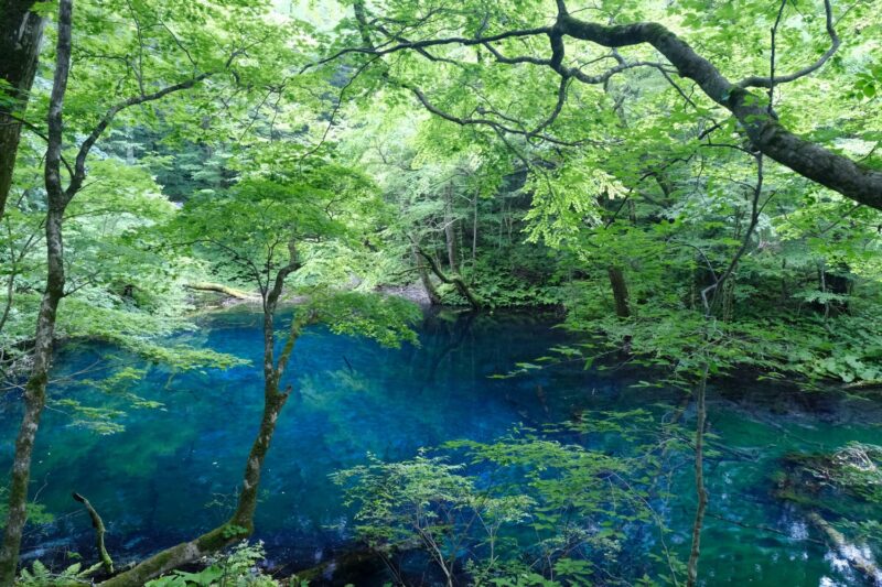
"Aoike" is not a landslide, but a pond formed by spring water
Most of the 33 lakes and marshes in Juniko are thought to have been formed when a stream flowing through it was blocked by a mudslide caused by a landslide, but the most famous, Aoike Pond, is formed by spring water
Aoike Pond is a small pond with a circumference of 125m, located at the highest elevation of the Juniko Lakes. The water is clear blue, and it was thought that the blue color was due to the presence of some dissolved substance, but research conducted in the 2000s finally solved the mystery
Three conditions that make water look blue
<For the water in the pond to look blue> The following three conditions must be met for this to happen
Just clear water
Water depth
White bottom
1. Crystal clear water
Water is colorless and transparent, but water that is deep, such as in the ocean or lakes, is blue. This is because when sunlight enters the water, reflects off the bottom, and then emerges, the red light is absorbed by the water first, and as the water gets deeper, the green light is also absorbed. However, blue light is not absorbed, so the water appears blue to the human eye. However, if the water is not transparent, the light is scattered by the impurities it contains, making it appear black. Also, if the impurities are colored, the water will take on that color
The water in Aoike Pond is spring water, so it contains almost no impurities, is very clear, and the bottom is easily visible. Condition 1 is met
2. Water depth
If the water is shallow, it reflects all light, but if it is deep, only blue is reflected. However, if the water is too deep, the reflected light does not reach the surface. It is thought that the ideal depth for the beautiful blue reflection is about 8 to 10 meters, as in the case of "Aoike Pond." Condition 2 is also met
3. White bottom
Light is reflected by white objects and absorbed by black objects. The bottom of Aoike Pond is made of white rock formed from solidified ejecta from an undersea volcano, which reflects light well. This also satisfies condition 3
The Blue Pond miraculously meets all three conditions, making it a pond that appears to be filled with clear blue water
The blue water of Aoike Pond changes with the time and season
The blue water of Aoike Pond appears blue because sunlight reflects off the bottom of the pond, but the color changes from pale blue to murky blue depending on the angle at which the light enters (angle of incidence). Furthermore, the bottom of Aoike Pond is shaped like a mortar, and gets deeper as you go towards the center. Therefore, depending on the angle of the light that enters, the reflected light will appear in different places. Furthermore, the angle of sunlight changes every day and with the seasons. This complex reflection of light causes the color to change from moment to moment
The color of the Blue Pond is generally light in summer and dark in winter, and is most beautiful in spring and autumn. In a single day, it is around noon. Of course, this is only possible on a clear, sunny day
For a stroll around the Juniko Lakes, Okujuniko Lake, which is close to Aoike Pond, is convenient
To explore Juniko Lakes, you can take either the western side, accessible via National Route 101 and the JR Gonō Line Juniko Station, or the eastern side, accessible via Prefectural Route 28 (Shirakami Line/Iwasaki-Nishimeya-Hirosaki Line), known as Okujuniko, where the "Blue Pond" is located. During the green season (mid-April to the end of November), a bus service operates from Juniko Station to Okujuniko, making it convenient (please inquire with Konan Bus).
*The walking trails may be closed due to weather conditions, etc. Please check the official Juniko Lakes website, "Juniko no Mori."
*Bear sightings are becoming more frequent. Please be careful and carry bells, whistles, bear repellent spray, etc., and refrain from traveling alone. Also, be careful of hornets
"Fukitsubo Pond" selected as one of the famous waters of the Heisei era
Wakitsubo Pond is located about 600m from Kyororo Forest Museum, the base for exploring the Juniko Lakes in Okujuniko, and is the second clearest pond after Aoike Pond. There is a spring on the shore of the pond, and the water that flows out is known as "Wakitsubo Pond's Pure Water" and has been selected as one of the "100 Famous Waters of the Heisei Era" by the Ministry of the Environment
Kanayama Pond: View of the massive collapse of Mount Kuzureyama
"Kanayama Pond" @Fukaura Town, where you can still see the exposed slope of the landslide
Kanayama Pond is a pond located in the innermost area of the Juniko Lakes, and offers a view of the mountainside of Okuzure, which is said to have collapsed during the Hoei Iwadate earthquake of 1704. It is located deep in the area and is a bit far for a stroll, but it offers some of the most beautiful scenery of the Juniko Lakes
The best view point of Lake Juniko: Okuzure Observatory
Mount Kuzureyama is said to have created the landscape of the Twelve Lakes. The "Okuzure Observatory" located on its slopes is a spectacular viewpoint overlooking the Twelve Lakes from the top of the landslide. A grand panorama unfolds before you, with several lakes and ponds sparkling amidst the lush forest, and beyond them, the vast Sea of Japan stretching out before you. The route involves a round-trip trek of approximately 3 hours, starting from the "Kyoro Forest Products Center" at an altitude of approximately 225m, passing through "Aoike Pond," and ending at the "Okuzure Observatory" at an altitude of approximately 694m. There are some steep climbs, so please exercise extreme caution.
The impressive "Japan Canyon" with its continuous white rock faces
The Juniko area is home to 33 lakes and ponds, as well as a number of other mystical landscapes created by nature, including virgin beech forests and the remains of a landslide known as the "Okuzure," one of which is the "Japan Canyon." The sheer cliffs are made up of white rock faces
The white rock is a type of volcanic rock called Juniko Tuff. This rock is of volcanic origin and is characterized by pale colors such as white, gray, and green. It was known that the white rock walls of "Japan Canyon" are tuff, but the process by which they were formed was unclear
Recently, students from Hirosaki University identified this as a lava dome, and announced their findings at a Geological Society meeting in 2024. According to their findings, the lava dome was formed by an undersea volcanic eruption that occurred approximately 12 million years ago, when the Shirakami-Sanchi area was still under the sea, and was brought to the surface by subsequent uplift activity (presented by Kanesashi Yui (24) and others from Hirosaki University at the Geological Society of Japan meeting in September 2024). The entrance to the observation deck at Japan Canyon is a parking lot near Hakkei no Ike, one of the Twelve Lakes. The observation deck is located at the foot of the sheer white rocks, and requires approximately 20 minutes of climbing up a mountain path. The path is well maintained, but there are steep inclines, so sturdy shoes are essential
"Kyororo Forest Products Center" is recommended as a base for exploring the Juniko Lakes
"Mori no Souvenir Center Kyororo" is a product center located next to the Okujuniko parking lot, the last stop on the bus route from JR Juniko Station. There is also parking for private cars and toilets, so it is recommended to use this as a base for day trips around the Juniko lakes
The Shirakami Juniko Eco Museum is a museum where you can learn about the Juniko Lakes and the Shirakami Mountains. After learning about the Juniko Lakes through panoramic exhibits and other displays, you can take a stroll along the footpath that continues from the museum, past the lakes and the primeval beech forest. It takes about 1 hour and 30 minutes one way to reach Aoike Pond (about 5 minutes by bus or car)
There is a cottage-style accommodation facility, "Aone Shirakami Juniko," adjacent to the facility, which is perfect for staying overnight and enjoying a full-scale stroll around the Juniko Lakes and Shirakami-Sanchi Mountains
Public transportation: Free shuttle bus or local bus from Juniko Station on the JR Gono Line, approximately 5 minutes, or 20 minutes on foot from Juniko Station
By car: Approximately 1 hour and 10 minutes from Noshiro Minami IC on the Akita Expressway
My love of travel led me to work for a travel magazine some time ago, and now I work as a travel writer for an online publication. I have visited all 47 prefectures in Japan, focusing on the Tohoku region, and I enjoy soaking in hot springs and experiencing traditional Japanese culture, including old townscapes, lifestyles, and performing arts and crafts