Let's go see the natural Akita cedars [2] A forest of natural Akita cedars with giant trees over 200 years old
table of contents
- 1 Shichizayama has been carefully protected since the Edo period as a direct mountain of the Kubota domain
- 2 A natural Akita cedar forest protected as the "Shichizayama Nature Observation Education Forest"
- 3 Yatate Pass is located on the border between Akita and Aomori prefectures, and was the site of a long-running border dispute during the Edo period
- 4 The few remaining natural Akita cedar forests at Yatate Pass are protected as the Yatate Pass Recreation Forest
- 5 The natural forest where old tales are passed down and the Thirty-three Kannon stone statues remain: "Fusazumiyama Nature Observation and Education Forest"
- 6 Hirataki Nature Observation and Education Forest - Forest of Interaction - is a recreational forest developed in a natural Akita cedar forest
- 7 80 huge cedar trees line the left and right of Kinpu Shrine
"Let's go see natural Akita cedars [1 ]," we introduced some representative old natural Akita cedar trees and the natural forests where they grow. Here, we have mainly picked out natural forests that have well-maintained walking trails where you can enjoy forest bathing relatively easily.
Shichizayama has been carefully protected since the Edo period as a direct mountain of the Kubota domain
Nanakurasan , Gongenkura , is the highest, but it is a low mountain with an elevation of 287m. Legend has it that Kobo Daishi Kukai (774-835) also visited this mountain, and it has been a sacred place where Shugensha (mountain priests) have practiced their training since ancient times.
The Seven Mountains are a chain of seven peaks each measuring 159.1m above sea level, Matsukura Okura, 163.6m), Sanbonsugikura ( 153.7m), Shibakura (173.1m), Minokura (192.4m), Eboshikura (229.6m), and Gongenza. Scattered throughout the mountains are lion heads said to have been carved by Jikaku Daishi Ennin (794-864), as well as small shrines that are testament to his training.

During the Edo period, Shichizayama was carefully protected as an Ojikiyama ( direct mountain the Kubota Domain (Akita Domain). The surrounding cedar trees were sold in large quantities, mainly in Edo, and the mountain became so bald that there were no more trees to cut. However, the cedar trees on Shichizayama could not be touched, and miraculously, a natural Akita cedar forest remained.
The Edo period travel writer Sugae Masumi also visited Shichizayama in 1802 and painted a picture of the scenery from the opposite bank

A natural Akita cedar forest protected as the "Shichizayama Nature Observation Education Forest"
Of the forests of Mt. Shichiza, 99 hectares that are recognized as natural forest are protected as the Mt. Shichiza Nature Observation and Education Forest . Walking trails have been established within the protected forest, allowing visitors to stroll through the dense forest, which is dominated by natural Akita cedars.
The former Tenjinso site at the trailhead is a convenient base for exploring, with a parking lot. While it's a little far from the Shichizayama Nature Observation Education Forest, the well-equipped Futatsui Roadside Station is also available.
Shichizayama Nature Observation Education Forest is one of the most popular tourist spots along the Yoneshiro River, along with Kimimachizaka, an Akita Prefectural Park
Shichizayama Information
- Name: Mt.Nanaza
- Location: Futatsuicho, Noshiro City, Akita Prefecture
- Contact: Yoneshiro Western Forest Management Office
- Phone number: 0185-54-5511
- Free to wander around
- Beware of animals such as bears and deer
Futatsui Roadside Station Information
- Facility name: Futatsui Roadside Station
- Address: 51 Kotsunagiizumi, Futatsui-cho, Noshiro City, Akita Prefecture
- Phone number: 0185-74-5118
- URL: Futatsui Roadside Station
- access:
- Public transportation: Get off at Futatsui Station on the JR Ou Main Line, take the Futatsui Community Bus for about 9 minutes, then take the Futatsui Roadside Station bus stop (community buses do not operate on Sundays and holidays), or take a taxi for about 5 minutes
- By car: Approximately 10 minutes from Futatsui Shirakami IC on the Akita Expressway, or approximately 15 minutes from Odate Noshiro Airport IC on the Akita Expressway
Google Map
Yatate Pass is located on the border between Akita and Aomori prefectures, and was the site of a long-running border dispute during the Edo period

Yatate Pass is a pass on the border between Odate City, Akita Prefecture and Hirakawa City, Aomori Prefecture. Although it is not particularly high at 258m above sea level, the pass is surrounded by a dense forest of Akita cedars, and during the Edo period, the pass was the site of constant conflict over the boundary between the Kubota Domain and the Tsugaru Domain (Aomori Prefecture).
Yatatesugi which was established during the Heian period as the tree that was hit by an arrow shot from the pass. Yatatesugi is located a little way inside the Tsugaru domain from the top of the pass, but the Tsugaru domain claimed that "the boundary is not at Yatatesugi, but at the top of the pass," which led to an argument with the Kubota domain.
The feudal domain boundary continued to be disputed for 150 years, and it was not until 1746 that the Edo Shogunate finally decided that Yatatesugi was the boundary

That decision is still observed today, and the border between Akita and Aomori prefectures passes near Yatate Cedar. The Yatate Cedar trees have been broken or cut down since the Edo period. Now, the third generation has been planted near the stump of the second generation, counting from the Edo period. The Yatate Cedar is located in Akita prefecture
The few remaining natural Akita cedar forests at Yatate Pass are protected as the Yatate Pass Recreation Forest
The old Ushu Kaido road passed through Yatate Pass, Tadataka (1745-1818) Masumi (1754-1829), Yoshida Shoin (1830-1859), crossed the pass. At the time, the area around the pass was a natural Akita cedar forest, and the British female traveler and travel writer Isabella Lucy Bird (1831-1904), who arrived in Japan in 1878 (Meiji 11) , praised its grandeur and beauty in , Unbeaten Tracks in Japan
Since the Meiji era, most of the natural Akita cedars at Yatate Pass have been cut down and replaced with planted artificial forests, but the remaining 10 hectares of natural forest have been designated as Yatate Scenic Forest Preservation been protected as the Recreational Forest: Yatate Pass Scenic Forest Peaceful Forest History Road: Yatate Pass Promenade, a safe trekking course equipped with guide maps, signposts, information boards, gazebos, and more .

base is the Yatate Pass/Odate Yatate Heights Roadside Station The roadside station's parking lot can be used for strolling, and the building has pamphlets with information on walking routes. There are also staff members who are knowledgeable about the area, so it's a good idea to gather information before you set off.
Historical Road Yatate Pass Promenade Information
- Location: Historical Road, Yatate Pass Promenade
- Free to wander around
- Beware of animals such as bears and deer
- Facility name: Roadside Station "Yatate Toge" / Odate Yatate Heights
- Address: 311 Jinba, Nagahashiri, Odate City, Akita Prefecture
- Phone number: 0186-51-2311
- Please check the accommodation fees and other information on the website or travel site
- <Day trip hot spring>
- Usage hours: 10:00-15:00
- Price (including shared room break): 700 yen for junior high school students and above, 400 yen for elementary school students
- URL: Roadside Station "Yatate Pass"
- access:
- Public transportation: Approximately 25 minutes by taxi from Odate Station on the JR Ou Main Line
- By car: Approximately 7 minutes from Ikarugaseki IC on the Tohoku Expressway, approximately 20 minutes from Odate Kita IC on the Akita Expressway
Google Map
The natural forest where old tales are passed down and the Thirty-three Kannon stone statues remain: "Fusazumiyama Nature Observation and Education Forest"

Mount Boju is the Kotooka of Mitane Town and the Futatsui district of Noshiro City , with an elevation of approximately 409m. Within a 5km radius are the Nifu Mizusawa Cedar Plant Community Protection Forest and the Kobu Cedar Nature Observation Education Forest , and the area is home to many natural Akita cedars.
The dense forest has been designated as the " Mt. Fusatsuzumi Nature Observation Education Forest ," and is home to many giant natural Akita cedar trees over 200 years old, mixed with broad-leaved trees such as beech, creating a natural forest.

Mount Fusami is home Sakanoue no Tamuramaro (758-811) and the three Nagatsura brothers of the indigenous clan. It has also flourished as a base for mountain Buddhism since ancient times, and is a mountain of faith where the Thirty-three stone statues of the Kannon Bodhisattva, erected during the Edo period, still remain along the mountain trails.
The story of the three Nagamen brothers is a folktale that Sugae Masumi heard from a village elder and recorded in Fusazumiyama Mukashi Monogatari Aketomaru , Akerumaru , and Akeshimaru , and their victory. The three brothers were described as giants, with long faces measuring about 70cm and being over 3m tall, with the eldest, Aketomaru, standing over 5m tall.
According to historical fact, Sakanoue no Tamuramaro never came to Akita, so it is not known when this story began to be told
It takes about two hours to trek from the trailhead to the summit, which offers a panoramic view Mount Moriyoshi (1,454m above sea level) to the east, Ogata Village (formerly Lake Hachirogata), the Oga Peninsula, and the Sea of Japan to the west.
Fusumiyama Nature Observation Education Forest Information
- Facility name: Mt. Fusatsuyama Nature Observation and Education Forest
- Location: Takinoue, Kamiiwakawa, Mitane Town, Akita Prefecture
- Contact: Mitane Town Tourism Association
- Phone number: 0185-88-8020
- Free to wander around
- Beware of animals such as bears and deer
- URL: Mt. Fusatsuyama Nature Observation and Education Forest
- access:
- Public transportation: Approximately 20 minutes by car from Shikado Station on the JR Ou Main Line, then walk from the parking lot at "Bojukan" or the Ido Shimoda trailhead (near Fusazumi Shrine)
- By car: From Kotooka Moritake IC on the Akita Expressway, take the Kotooka-Kamikoani Prefectural Road towards Kamikoani Village for about 20 minutes, then walk from the parking lot at "Bojukan" or the Ido Shimoda trailhead (near Fusazumi Shrine)
Google Map
Hirataki Nature Observation and Education Forest - Forest of Interaction - is a recreational forest developed in a natural Akita cedar forest

Hirataki Nature Observation and Education Forest - Forest of Interaction - Mt. , which towers over the border between Odate City in northern Akita Prefecture and Aomori Prefecture.
The educational forest includes a grove of natural Akita cedar trees over 150 years old, a broadleaf forest of Mongolian oak, horse chestnut, and chestnut trees, and a forest plaza.The area is equipped with walking paths (total length approximately 1,167m), a gazebo, field athletics, toilets, outdoor tables, drinking fountains, signs, and a multilingual audio guide system (Univoice), so anyone can freely explore the area
Hirataki Nature Observation and Education Forest - Forest of Communication - Information
- Location: Hirataki Nature Observation Education Forest - Forest of Communication
- Location: Hayakuchi Hirataki, Odate City, Akita Prefecture
- Contact: Odate City Tashiro General Branch Office, Regional Development Section
- Phone number: 0186-43-7103
- Free to wander around
- Beware of animals such as bears and deer
- URL: Hirataki Nature Observation and Education Forest - Forest of Interaction -
- access:
- Public transportation: Approximately 40 minutes by car from JR Ou Main Line Hayaguchi Station
- By car: Approximately 50 minutes from Odate Minami IC on the Akita Expressway
Google Map
80 huge cedar trees line the left and right of Kinpu Shrine

" Kinpo Shrine Cedar Row " has 41 trees on the left side of the approach and 39 on the right, many of which are giant trees up to about 30m in height and are estimated to be between 100 and 400 years old. The cedar trees lining the approach are said to be an artificial forest, but the spacing between the trees is uneven and many of them are still small, so it is thought that this may be a natural forest.
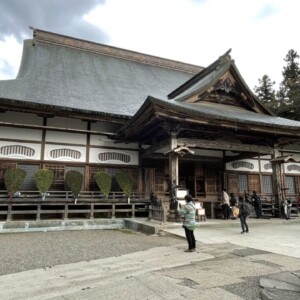
Kinpu Shrine is a historic shrine said to have been founded 1,300 years ago, with the worship hall built before the Edo period and the Niomon Gate built towards the end of the Edo period. The Niomon Gate houses two Nio statues carved from a single giant cedar tree. The "Cedar Row at Kinpu Shrine" is a designated natural monument of Akita Prefecture, and the worship hall, Niomon Gate, Nio statues and Chikaramochi statues of Kinpu Shrine are designated tangible cultural properties of Senboku

Information about the cedar trees at Kinpu Shrine
- Facility name: Kinpu Shrine
- Address: 235 Umezawa Higashida, Tazawako, Senboku City, Akita Prefecture
- For inquiries, please contact: Semboku City Tazawako Tourist Information Center "Folake"
- Phone number: 0187-43-2111
- Free to wander around
- Beware of wild animals such as bears and deer
- access:
- Public transportation: Akita Shinkansen, JR Tazawako Line, Akita Nairiku Jukan Railway, approximately 15 minutes by car from Kakunodate Station
- By car: Approximately 45 minutes from Kyowa IC on the Akita Expressway



![Let's go see the natural Akita cedars [1] The striking natural Akita cedars Kimimachi Cedar_Travel Tohoku](https://jp.neft.asia/wp-content/uploads/2025/08/8e9866308062a0263d3dc4be0085b6be-150x150.jpg)
![[Takko Town, Aomori Prefecture] Tapkopu Soyu Village is a popular spot for hands-on tourism! Couples and families can make their own "mochi senbei" rice crackers! bba9278e99ecc877484ea30022072239_m](https://jp.neft.asia/wp-content/uploads/2017/08/bba9278e99ecc877484ea30022072239_m-150x150.png)
![[Karita District, Miyagi Prefecture] Zao Dairy Center is a dairy amusement park! Experience making your own cheese and sausages! Sheep](https://jp.neft.asia/wp-content/uploads/2018/03/a904b376d3f083f370e4fdde45dbaaa6_s-150x150.jpg)
![Experience fossil excavation at the Ammonite Center! [Iwaki City, Fukushima Prefecture] fossil](https://jp.neft.asia/wp-content/uploads/2018/06/4067262_m-150x150.jpg)
![[Sukagawa, Fukushima Prefecture] "Mushi Tech World" is an interactive facility where you can learn about everything from insects to science! Become a pilot and fly the skies of Fukushima 0605-006](https://jp.neft.asia/wp-content/uploads/2018/09/0605-006-150x150.jpeg)

![[Iwate] Highlights of the two major zoos! Morioka Zoological Park and Iwate Safari Park 69943e83eac371a81ca178fbb1226387_m](https://jp.neft.asia/wp-content/uploads/2017/05/69943e83eac371a81ca178fbb1226387_m-150x150.png)
![[Miyagi Prefecture] Enjoy a free tour of the Nikka Whisky Miyagikyo Distillery, including tastings! Nikka Whisky Miyagikyo Distillery](https://jp.neft.asia/wp-content/uploads/2018/03/IMG_1959-150x150.jpg)
![Koriyama brand vegetables [Green Sweet]](https://jp.neft.asia/wp-content/uploads/2024/09/IMG_8104-300x300.jpg)
