


To the Sea of Japan? To the Pacific Ocean? The Sakaida Watershed, a watershed in the Ou Mountains visible in the lowlands [Yamagata Prefecture]

Mogami Town in Yamagata Prefecture is located near the border with Miyagi Prefecture
In the Sakaida district of this town lies the Sakaida Watershed , a fateful branching point where the water flow from the Ou Mountains splits into east and west, eventually flowing into the Sea of Japan and the Pacific Ocean
When you hear the word "watershed," you might generally picture a ridge line of steep mountains, but the Sakaita Watershed is located on flat land in front of Sakaita Station on the JR Rikuu East Line. You can observe the moment when the water's course is divided, right after getting off the train
This article introduces the "Sakaida Watershed," where you can feel the flow of water from the Ou Mountains that divide the Japanese archipelago into east and west , and the "House of the Border Guard," which remains in the surrounding area and is associated with Matsuo Basho!
Watershed and Divide
Generally, these points where water flows diverge are called watersheds or tributaries
A "watershed" is a geographical term referring to the boundary where rainwater that falls on the ground flows into different river systems. When such a boundary runs along a mountain ridge, it is called a "watershed."
In particular, boundaries that divide large river basins between the Sea of Japan and the Pacific Ocean, such as the Sakaida Watershed,"Great Watersheds,"and in the Tohoku region, the Ou Mountains play this role.

Sakaida is located on a mountain pass called "Sakaida Pass" or "Nakayama Pass" that crosses the Ou Mountains, but there are no steep ridges or slopes around the watershed. It is situated in a flat area with rice fields and settlements, and local information boards state its elevation as 338m
For the reasons mentioned above, it is known as "Sakai-da Watershed" as a tourist destination, but geographically it is not located on a mountain ridge or anything similar, so it is actually a "watershed."
A rare spot where the water splits into two right before your eyes

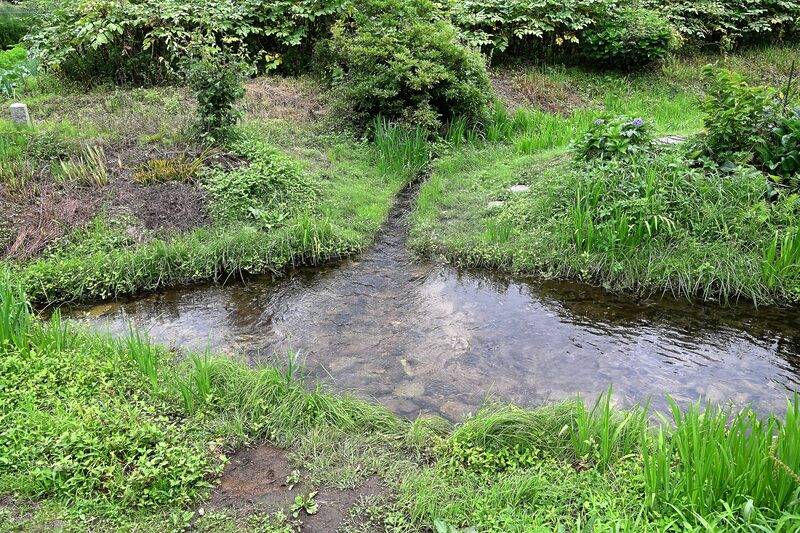
The Sakaita watershed is where water flowing from the north meets the plaza in front of JR Sakaita Station, splitting into east and west
At first glance, it looks like a small waterway flowing through a village, but the water that crosses the branching point never rejoins. The water that heads east goes to the Pacific Ocean from Ishinomaki City, Miyagi Prefecture, and the water that heads west goes to the Sea of Japan from Sakata City, Yamagata Prefecture...each embarking on a journey of over 100km

While watersheds on mountain ridges don't always allow us to observe the branching of a single stream because rainwater splits into two streams on the left and right sides of the slope, in Sakaida, the waterway itself splits into two, albeit on a small scale, allowing us to visually understand the major watershed of the Ou Mountains that divides the Japanese archipelago east to west
Where do the separated waters flow to?

The information board installed at the site shows the routes of the rivers from the Sakaida watershed to the Pacific Ocean and the Sea of Japan, along with the distances to each
The water from the east flows from Ishinomaki City, Miyagi Prefecture, into the Pacific Ocean
The water that flows eastward from the junction will then head towards the Pacific Ocean via the following path
- Sakaida watershed
- Otani River tributary
- Otani River
- Eai River
- Old Kitakami River
- From Ishinomaki City, Miyagi Prefecture to the Pacific Ocean
According to the local information board, the distances are as follows: Otani River tributary 1.0 km, Otani River 10.3 km, Egai River 84.8 km, and Old Kitakami River 20.1 km. The total distance from Sakaita watershed to the Pacific Ocean is 116.2 km
The small stream that flows eastward joins the Egai River in Miyagi Prefecture, then flows through the former Kitakami River before emptying into the Pacific Ocean in Ishinomaki City
The waters from the west flow from Sakata City, Yamagata Prefecture, into the Sea of Japan
The water that flows west from the junction will then head towards the Sea of Japan via the following path
- Sakaida watershed
- Ashigazawa River
- Myojin River
- Mogami Oguni River
- Mogami River
- From Sakata City, Yamagata Prefecture to the Sea of Japan
The distances indicated on the local information board are 1.4 km for the Ashigazawa River, 5.4 km for the Myojin River, 34.4 km for the Mogami-Oguni River, and 61.4 km for the Mogami River. The total distance to the Sea of Japan is 102.6 km
The Mogami-Oguni River is one of the main rivers in Mogami Town, and it merges with the Mogami River in Funagata Town. After that, it flows through Yamagata Prefecture and empties into the Sea of Japan from Sakata City
The water, which was once the same at the point of divergence, will eventually flow into two separate river mouths, one heading towards Ishinomaki City in Miyagi Prefecture and the other towards Sakata City in Yamagata Prefecture, ultimately reaching each other at a distance of approximately 200 km
JR Sakaita Station is located right next to the watershed
Sakaita Station on the JR Rikuu East Line is the closest station to the Sakaita Watershed. Although it's described as "closest," the watershed is actually located in the plaza in front of the station, so you can reach it in less than a minute on foot from the platform

Sakaita Station is located immediately after the Rikuu East Line crosses the Miyagi Prefecture border when viewed from the Yamagata Prefecture side. The neighboring Nakayamadaira Onsen Station is in Osaki City, Miyagi Prefecture, while Akakura Onsen Station on the opposite side is in Mogami Town, Yamagata Prefecture, the same town as Sakaita Station

In front of the station stands a wooden gate inscribed with "Watershed," "Pacific Ocean," and "Sea of Japan," indicating that Sakaita is a point where water from the Ou Mountains diverges
It's rare to find a station where you can see the Oita Watershed immediately after getting off the train, making it an interesting spot that can be enjoyed by both railway enthusiasts and geography lovers
Sakaida Watershed<Information>
- Name: Sakaida Divide
- Address: Sakaida, Mogami-cho, Mogami-gun, Yamagata Prefecture 999-6106
- Telephone number: 0233-43-2262 (Mogami Town Hall, Commerce and Tourism Division)
- Official URL:Mogami Town Official Website – Sakaida Watershed
Google Map
The former Ariji family residence (house of the border guard) where Matsuo Basho stayed
During the Edo period, Sakaida played a crucial role as a "boundary of human movement" connecting the Shinjo and Sendai domains. A building that tells this history is the "Former Ariji Family Residence," located very close to the Sakaida watershed , and is generally known as the "House of the Border Guard."
"Fūjin" is a term meaning an official who guards the border, and the Ariji family served as village headmen for generations in Sakaida Village, Oguni-go, Shinjo Domain during the Edo period. Their residence is said to have also served functions such as a village office, wholesale business, and inn

In 1689, during the Genroku era, Matsuo Basho, accompanied by his disciple Kawai Sora, entered Dewa Province from Mutsu Province on his journey chronicled in "Oku no Hosomichi" (The Narrow Road to the Deep North)
According to a local information board, Basho and Sora arrived in Sakaita Village at dusk on the 15th day of the 5th month of the lunar calendar. Due to the wind and rain of the rainy season, they postponed their departure the following day and stayed at the "border guard's house" until the early morning of the 17th

Basho described the sounds of horses urinating in the stables inside his house, and his impressions of nights plagued by fleas and lice, in the following poem:
Fleas and lice; horse urine; by the pillow
In farmhouses of that time, it was common to have a stable inside the main house where people lived. A literal translation of this haiku would be,"If you stay in a poor farmhouse, you will be bitten by fleas and lice, and there will be a horse by your pillow, and the sound of its urine will echo." Itcan be interpreted as expressing the inconveniences of travel, but it is also a valuable haiku that conveys the life of the Mogami region at that time, where horse breeding was thriving since the Edo period.


The current Old Ariji Residence is a large farmhouse with a single-story hipped roof and thatched roof, but its construction date is unknown. However, it is estimated to be more than 300 years old, and as a fine example of a large-room farmhouse remaining in northeastern Yamagata Prefecture, it was designated a National Important Cultural Property on December 18, 1969 (Showa 44)

The building underwent dismantling and restoration work from 1971 to 1973 under the supervision of the Agency for Cultural Affairs and other related organizations, and has been restored to what is estimated to be its original appearance
Former Ariji family residence <Information>
- Name: Former Ariji family residence (house of feudal lord)
- Address: 59-3 Sakaida, Mogami-cho, Mogami-gun, Yamagata Prefecture 999-6106
- Phone number: 0233-45-2397
- Viewing hours: 9:00-17:00
- Official URL:Mogami Town Official Website – Former Ariji Family Residence (House of the Border Guard)
Google Map
Sakaita, where the boundary between water and people overlaps
The Sakaida Watershed is neither a scenic spot with magnificent mountain ranges nor a waterfall with a massive flow of water; all that remains is a small waterway surrounded by grass and a gentle stream that splits into two. However, if you follow the water, one branch will lead to the Pacific Ocean and the other to the Sea of Japan... It's a place that evokes a sense of incredible romance when you imagine it
Furthermore, houses that once guarded the border remain in the surrounding area, and memories of Matsuo Basho's journey are also etched into the landscape
Sakaita district remains, then and now, a small settlement nestled in the mountains, but it is also a rare place where you can experience the precious boundary between water and people
Taking a moment to contemplate the Sea of Japan and the Pacific Ocean, the destinations of the water from the Ou Mountains, might make for a memorable part of your trip
Reference sites

Traveling around the Tohoku region, I enjoy drinking delicious sake and exploring the local history, traditions, and customs. I write articles based on my interests. I'm currently interested in folk performing arts, local toys, and folk beliefs
Please support NEFT's article creation!
NEFT gathers and publishes articles about the history, culture, and tourism information of various regions in Tohoku
If you enjoyed this article, we would be grateful if you would consider supporting our future interviews, article creation, and website management
*Clicking "Tip" will open the tip sending screen for the external service "codoc"
Other articles

[Iwate] Feel nostalgic! Morioka Station Retro...

[Nanyo City, Yamagata Prefecture] Japan's smallest lake? Lake Hakuryu is in danger of disappearing...

[Koriyama City, Fukushima Prefecture] What is "Takashiba Deco Yashiki"? Talking to locals...

Three Sengoku warlords from Miyagi Prefecture! Date Masamune, Katakura Kagetsuna, and Date Masazane

Apples, quince, rice, soybeans, black garlic, clams too...

Neither an express train nor an electric railway!? Bandai Express Electric Railway [Fukushima Prefecture]

Onikobe's Jigokudani Promenade! The bubbling steam and geysers are truly earth-sh...

[Tsuruoka, Yamagata Prefecture] Introducing 3 traditional sweets perfect as souvenirs! History...

[Iwate Prefecture] Spots that appear in the anime "Haikyu!!"...

A pilgrimage to 33 Kannon statues in three locations within Yamagata Prefecture, known as the "Dewa 100 Kannon"...

Let's become friends with the forest! Protect Akita's forests and pass them on to the next generation...
