


Recommended scenic driving route in Tohoku! National Route 341 (Kazuno City, Akita Prefecture to Lake Tazawa) offers stunning mountain scenery and takes you around two dam lakes and Lake Tazawa. [Akita Prefecture]

National Route 341, which runs north-south along the Akita Prefecture side of the Ou Mountains, is a route where you can encounter beautiful scenery created by the two dam lakes with their blue surfaces and the surrounding mountains
This article is a report of a drive along a scenic section of approximately 100km, from the starting point of Route 341 in Kazuno City to Lake Tazawa, where it overlaps with National Route 46
National Route 341 - A mountain route along the Ou Mountains

This is a national highway with a total length of 173.4 km, connecting Kazuno City in the northern inland part of Akita Prefecture and Yurihonjo City in the southern part on the Sea of Japan side
When it was designated a national highway in April 1975, it only ran from Kazuno City (the route we drove on this time) to Tazawako Town (now part of Semboku City), but it was extended to Yurihonjo City in April 1992
Kazuno Nagamine Intersection (start of national highway) to Shibari Onsen

Route 341 starts at the Nagamine intersection in southern Kazuno City, which is located on National Route 282, connecting Morioka City in Iwate Prefecture and Hirakawa City in Aomori Prefecture

If you head south from that intersection, following the Kumazawa River upstream, the houses and fields that were visible on both sides of the river gradually begin to disappear
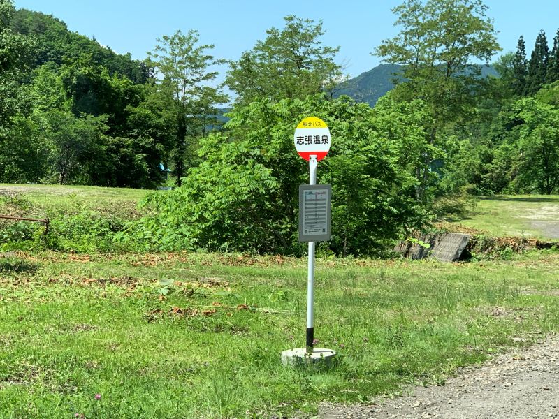
From the gate of the Akita Hachimantai Onsenkyo hot spring resort, located near the Shibari Onsen bus stop, a pleasant winding road through the forest continues
Shibari Onsen to Hachimantai Aspite Line Entrance

After passing through the gate, the road becomes increasingly uphill, and you can feel your altitude gradually increasing
There's a convenience store (Camel Mart Akita Hachimantai branch) in a villa area along the way. From here until Lake Tazawa, there are no more convenience stores or shops along the road, so it's a good idea to stock up on snacks and drinks here

Hachimantai Aspite Line

The Hachimantai Aspite Line (Iwate Prefectural Road No. 23) connects this junction to Hachimantai City in Iwate Prefecture, and is a magnificent mountain drive with a total length of approximately 27 km (toll-free)
During the winter months, the road is completely closed due to snow from early November to mid-April

During the snowmelt season, you can see the "snow corridors" that form after snow removal, as well as the mystical "Hachimantai Dragon Eye" located near the summit of Hachimantai
Hachimantai Aspite Line Entrance ~ Hachimantai/Obayachi ~ Tamagawa Onsen Entrance

The road becomes steeper from this point, and the mountain pass that marks the boundary between Kazuno City and Senboku City is approaching

The top of the pass is called "Hachimantai Obayachi," a wetland where various alpine plants grow in clusters, and it is a nature reserve with well-maintained walking trails
From this point onward, the road continues downhill
Hachimantai Onsenkyo - A vast plateau hot spring area

This is a collective term for famous and secluded hot springs such as Tamagawa, Goshogake, Fukenoyu, Ofuka, Onuma, and Fujishichi Onsen, located in Hachimantai, which spans Akita and Iwate prefectures, and is designated as a national health resort

Among them, Tamagawa Onsen, located on the slopes of Mt. Yakeyama in Akita and easily accessible from National Route 341, boasts the largest volume of hot spring water gushing from a single source in Japan, and is a highly acidic hot spring with hydrochloric acid as its main component, which is quite rare elsewhere

Walking trails are maintained around each hot spring, allowing visitors to observe different alpine plants depending on the season, and they also serve as nature research trails where volcanic activity can be observed
A little detour, part 1: Tamagawa Onsen hot spring source "Great Geyser"

The Obuke hot spring, the source of Tamagawa Onsen, is a rare hot spring in the world with a pH of 1.2, and approximately 9,000 liters of high-temperature spring water gush out every minute at a temperature of 98°C

This highly acidic hot spring is a popular destination for spa-goers not only from Japan but from all over the world, as it emits trace amounts of radiation and is known as a radium hot spring. Due to its high geothermal activity, many visitors spread mats on the rocks and enjoy a "natural bedrock bath" in the midst of nature

In addition to collecting mineral deposits from the "Great Geyser" and its surroundings, a walking trail called the "Nature Research Trail" has been developed, allowing visitors to observe volcanic activity such as other hot springs gushing from the rock face and steam from fumaroles stained yellow with sulfur
Tamagawa Onsen Entrance to Hosenko Observation Deck

Beyond Tamagawa Onsen, there are entrances to the Tamagawa Acidic Water Neutralization Facility and Shin-Tamagawa Onsen, and from this point onwards, the road becomes a pleasant winding road running along the Shibukurogawa River

Eventually, the Shibukuro River merges with the Tamagawa River and runs along its banks. Suddenly, at the Kanakura Bridge, located beyond the now-closed "Play Park Tose," Lake Hosen appears

From the beautiful blue Lake Hosen, a photogenic spot, to the Hosen Lake Observation Deck near Tamagawa Dam, there are six bridges spanning the lake, from which you can enjoy spectacular views of Lake Hosen
However, please remember not to drive while distracted and to thoroughly check for safety before stopping on a bridge for filming
A little detour, part 2: Around Tamagawa Dam

The area around Tamagawa Dam has facilities such as observation decks, museums, and parks, making it a photogenic spot that we recommend visiting while taking a break
Hosen Lake Observation Deck and Carillon Bells

Atop the tower at the Baoxian Lake Observation Deck stands the "Carillon Bell (Bell of Happiness)," a symbol of Baoxian Lake

The carillon bells ring automatically at set times, but the large central bell can be rung manually by anyone at any time, and I also gave it a try
To ring the large bell, you have to pull the rope hard many times to create momentum, which requires considerable strength and skill

It was exhilarating to hear the sound of the bell, which we had worked so hard to ring, echoing over Hosen Lake, but if left unattended, it would ring indefinitely, and stopping it required a lot of effort, making it quite difficult
Tamagawa Dam Museum

The museum displays information about the dam's construction process and role, as well as data on the organisms that inhabit the lake. It is open for viewing from 9 am to 5 pm, except during the winter when the national highway is closed (admission is free)
Tamagawa Dam Downstream Park

Downstream from the dam is a vast multi-purpose plaza with walking paths and waterways, perfect for picnics, events, and more

You can get close to the base of the towering dam, and the imposing sight of the dam, reminiscent of the "wall" that appeared in the manga "Attack on Titan," unfolds before your eyes
Hosenko Observation Deck ~ Akiogi Lake Dam Park

For a section of about 2km from Tamagawa Dam, you leave the Tamagawa River, but just after passing through the Takamori Tunnel, the spectacular view of Shusenko Lake appears at the Shin-Tamagawa Bridge

Akiogi Lake is a reservoir created by the Yoroihata Dam, which was built to secure water for agricultural and industrial use. The bridge and Akiogi Lake Dam Park are known as photogenic spots
A little detour, part 3: Yoroihata Dam

Although it's off the main road and has narrow, unpaved sections, resulting in fewer visitors, there's a photo frame for collecting dam cards, and you can get a dam card at the management office
Two dam lakes and a submerged forest shimmering in cobalt blue

The water in the Tamagawa River contains fine particles produced by the highly acidic water neutralization treatment at upstream facilities. These particles reflect sunlight, causing the lake water to shine with a vivid blue hue. In both lakes, during May and June when the water level rises due to snowmelt, the trees along the shores become submerged, creating a mystical submerged forest with trees floating on the cobalt blue surface of the lake
However, when I visited, the water level of the dam was low, so unfortunately I couldn't see the submerged forest
Below, I've included an article about the submerged forest at Akiogi Lake, which I visited during a previous season. Please feel free to refer to it

Akiogi Lake Dam Park to Tazawako Lake Entrance Intersection

Continuing south past Akiogi Lake, you will reach the Tazawako Entrance intersection, where it intersects with Akita Prefectural Road 38 (Tazawako-Nishiki Line), which leads to Tazawako Lake

One last detour: a stroll around the cobalt-blue Lake Tazawa!
Lake Tazawa boasts the deepest depth in Japan at 423.4 meters and is known for never freezing over even in the middle of winter. The lake's surface shines a stunning cobalt blue thanks to the blue water flowing in from the Tamagawa River

It would be a shame to just drive past this beautiful lake, so as the grand finale of our drive, we decided to take Prefectural Road 38 to Shirahama, known for its white "singing sand," and then drive counterclockwise around Lake Tazawa, which is almost perfectly circular with a circumference of about 20 km

The name of Gozaishi Shrine, located on the northern shore of the lake, originates from the fact that Satake Yoshitaka, the lord of the Akita domain, rested here by sitting on a stone during a sightseeing trip around Lake Tazawa
If you continue driving along the prefectural road that circles the lake for a while, you will see the bronze "Tatsuko statue" reflected in the blue surface of the lake

The statue of Tatsuko, who is said to have drunk the water from a spring after receiving a divine message to preserve her beauty forever, and transformed into a dragon and lake goddess, is mystical, as if emerging from the blue lake
After circling Lake Tazawa, return to the Lake Tazawa entrance intersection from Shirahama, turn right, and head south again on National Route 341
Tazawako Entrance Intersection to Nonaka Intersection, Semboku City

At the Nonaka intersection, located south of the former Tazawako town (now part of Semboku City), Route 341 overlaps with National Route 46, which connects Morioka City and Akita City
Furthermore, Route 341 continues to Yurihonjo City, overlapping with National Routes 105, 13, and 7, but this report only covers up to the Nonaka intersection
summary
National Route 341 is a highly recommended mountain driving route with many scenic spots amidst magnificent nature, yet with little traffic, making for a comfortable and enjoyable drive
In addition to the thrill of driving on winding roads, you can also enjoy hot springs and forest bathing, and if you have time, you can even enjoy walks to observe alpine plants and volcanic activity
Please note that Route 341 is closed to general traffic during the winter months (late November to mid-April), but during that time, there are four round trips per day by a regular direct bus service from JR Tazawako Station to Shin-Tamagawa Onsen
National Route 341 (Kazuno City, Akita Prefecture to Lake Tazawa) Driving Map
① Kazuno Nagamine Intersection
② Tamagawa Onsen Hot Spring Source "Great Geyser"
③Hosenko Observation Deck
④ Tamagawa Dam
⑤ Akiogi Lake Dam Park
⑥ Yorihata Dam
⑦ Tazawako Entrance Intersection (National Route 341 / Akita Prefectural Road 38)
⑧ Gozaishi Shrine Torii Gate
⑨ Tatsuko statue
⑩ Nonaka Intersection, Senboku City (National Route 46 / National Route 341)
Google Map

I'm a former Edoite (Tokyoite) who loves Morioka and the six prefectures of Tohoku, and I'm a big fan of history, gourmet food, travel, sports, alcohol, and choral singing.
I'll introduce you to interesting things, delicious food, and great places in Tohoku!
Please support NEFT's article creation!
NEFT gathers and publishes articles about the history, culture, and tourism information of various regions in Tohoku
If you enjoyed this article, we would be grateful if you would consider supporting our future interviews, article creation, and website management
*Clicking "Tip" will open the tip sending screen for the external service "codoc"
Other articles

Natayacho, Morioka City, a town of water that ticks away time. Woven together with spring water...

Opening in 2022! Fukushima Roadside Station in Ozasao, Fukushima Prefecture...

Connecting to space as a development base for large rocket engines...

[Akita] Pottery created by a famous scholar? "Ani ware"

[Akita] Yokote & Yuzawa Area: Full of Food and Sightseeing Attractions!

[Series 2: The Battle of Zenkunen and the Battle of Gosannen] Was the Battle of Zenkunen a truce?.

[Tsuruoka City, Yamagata Prefecture] Tsuruoka City is home to four national hot spring resorts

4 Recommended Local Train Lines in Fukushima Prefecture!.

What is the story behind the origin of Lake Inawashiro's Okinajima Island? [Fukushima Prefecture]

[Akita Prefecture] Popular Craft Beer | Akita Akura Beer...

Is there a sacred object that keeps moving between the mountaintop and the hot spring town at the foot of the mountain?.
